

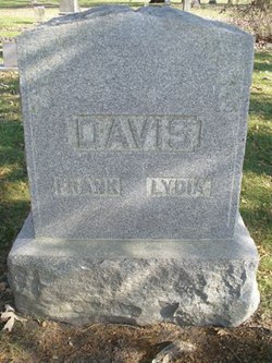
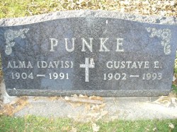
Alma Claudina Davis Punke
| Birth | : | 10 Dec 1904 Cerro Gordo County, Iowa, USA |
| Death | : | 8 Apr 1991 Iowa, USA |
| Burial | : | Kent Hollow Cemetery, Kent, Litchfield County, USA |
| Coordinate | : | 41.7043991, -73.4041977 |
frequently asked questions (FAQ):
-
Where is Alma Claudina Davis Punke's memorial?
Alma Claudina Davis Punke's memorial is located at: Kent Hollow Cemetery, Kent, Litchfield County, USA.
-
When did Alma Claudina Davis Punke death?
Alma Claudina Davis Punke death on 8 Apr 1991 in Iowa, USA
-
Where are the coordinates of the Alma Claudina Davis Punke's memorial?
Latitude: 41.7043991
Longitude: -73.4041977
Family Members:
Parent

Spouse
Siblings
Children


Nearby Cemetories:
1. Kent Hollow Cemetery
Kent, Litchfield County, USA
Coordinate: 41.7043991, -73.4041977
2. Morehouse Family Cemetery
Kent, Litchfield County, USA
Coordinate: 41.7071120, -73.4239170
3. Upper Merryall Cemetery
New Milford, Litchfield County, USA
Coordinate: 41.6678009, -73.4119034
4. Peet Cemetery
New Milford, Litchfield County, USA
Coordinate: 41.6753006, -73.4439011
5. New Preston Village Cemetery
New Preston, Litchfield County, USA
Coordinate: 41.6741104, -73.3523788
6. Underwood Meadow Cemetery
Washington, Litchfield County, USA
Coordinate: 41.6644300, -73.3611400
7. Flanders Cemetery
Kent, Litchfield County, USA
Coordinate: 41.7415900, -73.4593400
8. Good Hill Cemetery
Kent, Litchfield County, USA
Coordinate: 41.7494011, -73.4480972
9. Sacred Heart Cemetery
Kent, Litchfield County, USA
Coordinate: 41.7334862, -73.4703217
10. Averill Cemetery
Washington, Litchfield County, USA
Coordinate: 41.6663200, -73.3460600
11. Congregational Church Cemetery
Kent, Litchfield County, USA
Coordinate: 41.7312088, -73.4739685
12. Warren Center Cemetery Old
Warren, Litchfield County, USA
Coordinate: 41.7467117, -73.3492203
13. Saint Andrew's Cemetery
Kent, Litchfield County, USA
Coordinate: 41.7253304, -73.4782028
14. Northville Cemetery
New Milford, Litchfield County, USA
Coordinate: 41.6464005, -73.3846970
15. New Warren Cemetery
Warren, Litchfield County, USA
Coordinate: 41.7439480, -73.3438790
16. West Meetinghouse Cemetery
New Milford, Litchfield County, USA
Coordinate: 41.6497002, -73.4375000
17. Fanton Family Cemetery
New Milford, Litchfield County, USA
Coordinate: 41.6696892, -73.4705505
18. Saint Joseph Chapel Cemetery
Kent, Litchfield County, USA
Coordinate: 41.7270000, -73.4820200
19. Saint Michaels Chapel Cemetery
Kent, Litchfield County, USA
Coordinate: 41.6756700, -73.4793000
20. Alder City Cemetery
Kent, Litchfield County, USA
Coordinate: 41.7683000, -73.4349300
21. Schaghticoke Tribal Burial Ground
Kent, Litchfield County, USA
Coordinate: 41.6929800, -73.5013500
22. Balmoral Pet Cemetery
New Milford, Litchfield County, USA
Coordinate: 41.6594620, -73.4893723
23. Morningside Cemetery
Gaylordsville, Litchfield County, USA
Coordinate: 41.6511002, -73.4835968
24. Long Mountain Cemetery
New Milford, Litchfield County, USA
Coordinate: 41.6338997, -73.4586029