
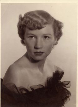

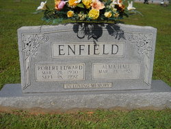
Alma Frances Hall Enfield
| Birth | : | 13 Mar 1926 Mount Airy, Surry County, North Carolina, USA |
| Death | : | 22 Dec 2018 Dobson, Surry County, North Carolina, USA |
| Burial | : | Mount Bethel Moravian Graveyard, Cana, Carroll County, USA |
| Coordinate | : | 36.6053120, -80.6272700 |
| Description | : | Mrs. Alma Frances Hall Enfield, 92, of Cana, VA, passed away Saturday, December 22, 2018, at the Joan and Howard Woltz Hospice Home in Dobson. She was born in Surry County on March 13, 1926, to the late Charlie Reverty and Mary Alice Tate Hall. In addition to her parents, Mrs. Enfield was preceded in death by her husband, Robert Edward Enfield; fourteen brothers and sisters. A memorial service will be held Wednesday, December 26, 2018, at 4:00 PM at Moody Funeral Home Chapel with the Rev. Ray Fleming officiating. The family will receive... Read More |
frequently asked questions (FAQ):
-
Where is Alma Frances Hall Enfield's memorial?
Alma Frances Hall Enfield's memorial is located at: Mount Bethel Moravian Graveyard, Cana, Carroll County, USA.
-
When did Alma Frances Hall Enfield death?
Alma Frances Hall Enfield death on 22 Dec 2018 in Dobson, Surry County, North Carolina, USA
-
Where are the coordinates of the Alma Frances Hall Enfield's memorial?
Latitude: 36.6053120
Longitude: -80.6272700
Family Members:
Parent
Spouse
Siblings


Nearby Cemetories:
1. Mount Bethel Moravian Graveyard
Cana, Carroll County, USA
Coordinate: 36.6053120, -80.6272700
2. Allen Cemetery
Cana, Carroll County, USA
Coordinate: 36.6155280, -80.6192210
3. Harrold Cemetery
Carroll County, USA
Coordinate: 36.6199300, -80.6219970
4. Flat Ridge Baptist Church Cemetery
Cana, Carroll County, USA
Coordinate: 36.5867470, -80.6298910
5. Westmoreland Cemetery
Cana, Carroll County, USA
Coordinate: 36.5850100, -80.6461990
6. Montgomery Family Cemetery
Ararat, Patrick County, USA
Coordinate: 36.6239760, -80.5977920
7. Gwynn Cemetery
Ararat, Patrick County, USA
Coordinate: 36.6298835, -80.6046284
8. Portis Cemetery
Ararat, Patrick County, USA
Coordinate: 36.6132460, -80.5890090
9. Gunnell Family Cemetery
Ararat, Patrick County, USA
Coordinate: 36.6034190, -80.5852510
10. Inscore Cemetery
Ararat, Patrick County, USA
Coordinate: 36.5988000, -80.5838000
11. Noonkester Family Cemetery
Ararat, Patrick County, USA
Coordinate: 36.6019990, -80.5830940
12. Speas Family Cemetery
Cana, Carroll County, USA
Coordinate: 36.5724564, -80.6447983
13. Gunnell - Bowman - Fleming Cemetery
Ararat, Patrick County, USA
Coordinate: 36.5898540, -80.5866110
14. Willis Gap Baptist Church Cemetery
Ararat, Patrick County, USA
Coordinate: 36.5925140, -80.5850250
15. Thomas Cemetery
Fancy Gap, Carroll County, USA
Coordinate: 36.6312940, -80.6592180
16. Mountain View Primitive Baptist Church Cemetery
Ararat, Patrick County, USA
Coordinate: 36.6127720, -80.5827530
17. Harrold Family Cemetery
Ararat, Patrick County, USA
Coordinate: 36.6197740, -80.5845790
18. Bear Trail Baptist Church Cemetery
Cana, Carroll County, USA
Coordinate: 36.6263910, -80.6655010
19. A.L. Jones Family Cemetery
Cana, Carroll County, USA
Coordinate: 36.5754410, -80.6561640
20. Oak Grove Baptist Church Cemetery
Cana, Carroll County, USA
Coordinate: 36.6432470, -80.6280060
21. Cana Baptist Church Cemetery
Cana, Carroll County, USA
Coordinate: 36.5920764, -80.6717347
22. Epworth United Methodist Church Cemetery
Cana, Carroll County, USA
Coordinate: 36.5736110, -80.6536110
23. Crooked Oak Moravian Church Cemetery
Cana, Carroll County, USA
Coordinate: 36.6385210, -80.6507840
24. Primitive Baptist Church Of Jesus Christ Cemetery
Cana, Carroll County, USA
Coordinate: 36.5917320, -80.6737210