Alonzo Dolphus “A. D.” Millirons
| Birth | : | 18 Sep 1865 Unionville, Putnam County, Missouri, USA |
| Death | : | 16 May 1931 |
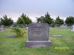
| Burial | : | Vermont Lutheran Church Cemetery, Black Earth, Dane County, USA |
| Coordinate | : | 43.0916710, -89.7477798 |
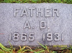
| Description | : | NAMES USED DURING LIFETIME: He was often called "A.D." and "Uncle Doll". Both his obituary and headstone named him "A.D." and did not give a full name. He was listed in one census at age 15 as Alonzo A. (Possibly A for Adolphus) and at least two other censuses as "Adolphus D." I am adopting Alonzo Dolphus here to match the initials he was most often known by: "A.D." OBITUARY: Concordia, KS Kansan, Thur, May 21, 1931: "A. D. MILLIRONS DEAD. A.D. Millirons, former mayor of Concordia and one of Concordia's best known citizens, died quite suddenly at his home (at)... Read More |
frequently asked questions (FAQ):
-
Where is Alonzo Dolphus “A. D.” Millirons's memorial?
Alonzo Dolphus “A. D.” Millirons's memorial is located at: Vermont Lutheran Church Cemetery, Black Earth, Dane County, USA.
-
When did Alonzo Dolphus “A. D.” Millirons death?
Alonzo Dolphus “A. D.” Millirons death on 16 May 1931 in
-
Where are the coordinates of the Alonzo Dolphus “A. D.” Millirons's memorial?
Latitude: 43.0916710
Longitude: -89.7477798
Family Members:
Parent
Spouse
Siblings
Children
Flowers:
Nearby Cemetories:
1. Vermont Lutheran Church Cemetery
Black Earth, Dane County, USA
Coordinate: 43.0916710, -89.7477798
2. Vermont Pioneer Cemetery
Black Earth, Dane County, USA
Coordinate: 43.0941600, -89.7530500
3. Old Black Earth Cemetery
Black Earth, Dane County, USA
Coordinate: 43.1301650, -89.7443720
4. Harlow Burial Ground
Cross Plains, Dane County, USA
Coordinate: 43.1280710, -89.7020370
5. Oak Hill Cemetery
Black Earth, Dane County, USA
Coordinate: 43.1439018, -89.7386017
6. Saint James Catholic Cemetery
Vermont, Dane County, USA
Coordinate: 43.0561100, -89.8097200
7. North Side Cemetery
Mount Horeb, Dane County, USA
Coordinate: 43.0242004, -89.7257996
8. Saint Ignatius Calvary Cemetery
Mount Horeb, Dane County, USA
Coordinate: 43.0212173, -89.7150210
9. Saint Mary of Pine Bluff Catholic Church Cemetery
Pine Bluff, Dane County, USA
Coordinate: 43.0555500, -89.6586100
10. Saint Johns Lutheran Church Cemetery
Black Earth, Dane County, USA
Coordinate: 43.1538800, -89.6804010
11. Valley Home Cemetery
Cross Plains, Dane County, USA
Coordinate: 43.1105500, -89.6402700
12. Mount Horeb Union Cemetery
Mount Horeb, Dane County, USA
Coordinate: 43.0107994, -89.7294006
13. First Norwegian Lutheran Cemetery
Mount Horeb, Dane County, USA
Coordinate: 43.0172460, -89.6984120
14. Saint Francis Xavier Cemetery
Cross Plains, Dane County, USA
Coordinate: 43.1205520, -89.6351020
15. Mazomanie Cemetery
Mazomanie, Dane County, USA
Coordinate: 43.1662000, -89.8139000
16. Saint Barnabas Cemetery
Mazomanie, Dane County, USA
Coordinate: 43.1676000, -89.8143000
17. Springdale Lutheran Church Cemetery
Mount Horeb, Dane County, USA
Coordinate: 43.0062294, -89.6904984
18. West Blue Mounds Lutheran Cemetery
Blue Mounds, Dane County, USA
Coordinate: 43.0138800, -89.8247200
19. Circle Sanctuary
Barneveld, Iowa County, USA
Coordinate: 43.0703500, -89.8765600
20. Dover Culver Cemetery
Arena, Iowa County, USA
Coordinate: 43.1627998, -89.8388977
21. Sunning Hill Cemetery
Marxville, Dane County, USA
Coordinate: 43.1903000, -89.6980000
22. German Valley Cemetery
Blue Mounds, Dane County, USA
Coordinate: 42.9808006, -89.7889023
23. Bethel Cemetery
Barneveld, Iowa County, USA
Coordinate: 43.0386009, -89.8906021
24. Dunlap Cemetery
Mazomanie, Dane County, USA
Coordinate: 43.2083015, -89.7288971

