
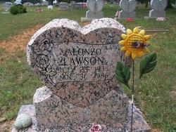
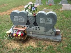
Alonzo Lawson
| Birth | : | 25 Jul 1935 Oklahoma, USA |
| Death | : | 31 Jan 1986 St. Francois County, Missouri, USA |
| Burial | : | Tucker Cemetery, Osage, Mitchell County, USA |
| Coordinate | : | 43.2494011, -92.8319016 |
| Description | : | Alonzo Lawson, 50, of Frankclay, died Jan. 31 at Mineral Area Osteopathic Hospital. He was born July 25, 1935 in Oklahoma to the late Grover and Lura Lawson. He is survived by one son, Mark Lawson, of Frankclay; one daughter, Lisa (Mrs. Mike) Mills, of Irondale; one brother, Glenwood Lawson, of Wortham; one sister, Estelle McCoy, of Leadwood and three grandchildren. Funeral services were held 2 p.m. Sunday at the Bert Boyer Funeral Chapel with Rev. Davey Welker officating. Burial was in Adams Cemetery |
frequently asked questions (FAQ):
-
Where is Alonzo Lawson's memorial?
Alonzo Lawson's memorial is located at: Tucker Cemetery, Osage, Mitchell County, USA.
-
When did Alonzo Lawson death?
Alonzo Lawson death on 31 Jan 1986 in St. Francois County, Missouri, USA
-
Where are the coordinates of the Alonzo Lawson's memorial?
Latitude: 43.2494011
Longitude: -92.8319016
Family Members:
Parent

Siblings

Flowers:


Nearby Cemetories:
1. Tucker Cemetery
Osage, Mitchell County, USA
Coordinate: 43.2494011, -92.8319016
2. Calvary Cemetery
Osage, Mitchell County, USA
Coordinate: 43.2238998, -92.8300018
3. South Osage Mennonite Church Cemetery
Osage, Mitchell County, USA
Coordinate: 43.2544556, -92.7915573
4. Sacred Heart Cemetery
Osage, Mitchell County, USA
Coordinate: 43.2742004, -92.7917023
5. Dudley Cemetery
Dudley (historical), Mitchell County, USA
Coordinate: 43.2252998, -92.8743973
6. Orchard Cemetery
Orchard, Mitchell County, USA
Coordinate: 43.2249985, -92.7838898
7. Osage Cemetery
Osage, Mitchell County, USA
Coordinate: 43.2916700, -92.8201700
8. Rock Creek Cemetery
Meroa, Mitchell County, USA
Coordinate: 43.2352791, -92.9225006
9. Eden Presbyterian Cemetery
Meroa, Mitchell County, USA
Coordinate: 43.2131004, -92.9103012
10. Oak Grove Cemetery
Mitchell, Mitchell County, USA
Coordinate: 43.3156013, -92.8707962
11. West End Cemetery
Meroa, Mitchell County, USA
Coordinate: 43.2216682, -92.9250031
12. Howardville Cemetery
Floyd, Floyd County, USA
Coordinate: 43.1866989, -92.7016983
13. Riverview Cemetery
Saint Ansgar, Mitchell County, USA
Coordinate: 43.3430328, -92.9220200
14. Stillwater Cemetery
Orchard, Mitchell County, USA
Coordinate: 43.2130585, -92.6780624
15. Rudd Evergreen Cemetery
Rudd, Floyd County, USA
Coordinate: 43.1417007, -92.9214020
16. Saint Johns Lutheran Cemetery
Rock Creek, Mitchell County, USA
Coordinate: 43.3295560, -92.9849770
17. Immanuel Lutheran Cemetery
Saint Ansgar, Mitchell County, USA
Coordinate: 43.3717003, -92.9257965
18. Saint Ansgar Cemetery
Saint Ansgar, Mitchell County, USA
Coordinate: 43.3777809, -92.9094391
19. Saint Johns Lutheran Old Cemetery
Rock Creek, Mitchell County, USA
Coordinate: 43.3313904, -92.9897232
20. Saint Peters Cemetery
New Haven, Mitchell County, USA
Coordinate: 43.2858315, -92.6427765
21. Blakestad Cemetery
Saint Ansgar, Mitchell County, USA
Coordinate: 43.3711014, -92.9400024
22. Beaver Creek Cemetery
Brownville, Mitchell County, USA
Coordinate: 43.3397217, -92.6727829
23. First Lutheran Cemetery
Saint Ansgar, Mitchell County, USA
Coordinate: 43.3841705, -92.9194412
24. Oakwood Cemetery
Floyd, Floyd County, USA
Coordinate: 43.1178017, -92.7307968