
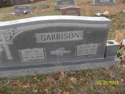
Alpha O Williams Garrison
| Birth | : | 6 Apr 1917 Gatewood, Ripley County, Missouri, USA |
| Death | : | 16 Feb 2007 Thayer, Oregon County, Missouri, USA |
| Burial | : | Byrd Cemetery, Myrtle, Oregon County, USA |
| Coordinate | : | 36.5186005, -91.3143997 |
| Description | : | Alpha was a homemaker as well as business woman. She cared for her home and raised two sons and and a daughter. She and husband Jesse owned and operated livestock auctions in Missouri and Arkansas. Alpha was known as a talented and wonderful cook. Cooking many meals on the farm for the hired hands and family. Alpha was a member of the Freewill Baptist Church. |
frequently asked questions (FAQ):
-
Where is Alpha O Williams Garrison's memorial?
Alpha O Williams Garrison's memorial is located at: Byrd Cemetery, Myrtle, Oregon County, USA.
-
When did Alpha O Williams Garrison death?
Alpha O Williams Garrison death on 16 Feb 2007 in Thayer, Oregon County, Missouri, USA
-
Where are the coordinates of the Alpha O Williams Garrison's memorial?
Latitude: 36.5186005
Longitude: -91.3143997
Family Members:
Parent

Spouse

Siblings
Children


Nearby Cemetories:
1. Crass Homestead
Myrtle, Oregon County, USA
Coordinate: 36.5359695, -91.3084671
2. Myrtle Cemetery
Myrtle, Oregon County, USA
Coordinate: 36.5133900, -91.2664300
3. Guiteau-Risner Cemetery
Guiteau, Oregon County, USA
Coordinate: 36.5588074, -91.3156128
4. Church of God Cemetery
Oregon County, USA
Coordinate: 36.5023500, -91.2580200
5. James Cemetery
Randolph County, USA
Coordinate: 36.4660988, -91.3435974
6. Arytown Cemetery
Arytown, Oregon County, USA
Coordinate: 36.5539513, -91.3795776
7. John Brown Cemetery
Jobe, Oregon County, USA
Coordinate: 36.5812111, -91.2953568
8. Garfield Cemetery
Garfield, Oregon County, USA
Coordinate: 36.5844400, -91.3253400
9. Davis Cemetery
Sharp County, USA
Coordinate: 36.4606018, -91.3574982
10. Taylor Cemetery
Ravenden Springs, Randolph County, USA
Coordinate: 36.4468994, -91.3293991
11. Russell Cemetery
Couch, Oregon County, USA
Coordinate: 36.5506477, -91.3991928
12. Cotton Creek Cemetery
Jobe, Oregon County, USA
Coordinate: 36.5844002, -91.2652969
13. O'Neal
Billmore, Oregon County, USA
Coordinate: 36.5712170, -91.2415410
14. Olon Tucker Farm Cemetery #2
Couch, Oregon County, USA
Coordinate: 36.5867000, -91.3705400
15. Wirth Cemetery
Wirth, Sharp County, USA
Coordinate: 36.4522018, -91.3806000
16. Old Jobe Cemetery
Jobe, Oregon County, USA
Coordinate: 36.5917015, -91.2517014
17. Rose Hill Cemetery
Thayer, Oregon County, USA
Coordinate: 36.5186386, -91.4263763
18. Pleasant Ridge Cemetery
Sharp County, USA
Coordinate: 36.4876710, -91.4221830
19. Spring Valley Cemetery
Billmore, Oregon County, USA
Coordinate: 36.5324670, -91.2003420
20. Old Elmore Thomas field
Billmore, Oregon County, USA
Coordinate: 36.5237770, -91.1980250
21. New Salem Cemetery
Couch, Oregon County, USA
Coordinate: 36.6042252, -91.3712463
22. Walnut Grove Cemetery
Elm Store, Randolph County, USA
Coordinate: 36.4914017, -91.1967010
23. Bellah Cemetery
Ravenden Springs, Randolph County, USA
Coordinate: 36.4207993, -91.2825012
24. Roberts Family Farm Cemetery
Couch, Oregon County, USA
Coordinate: 36.6165300, -91.2401700