

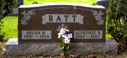
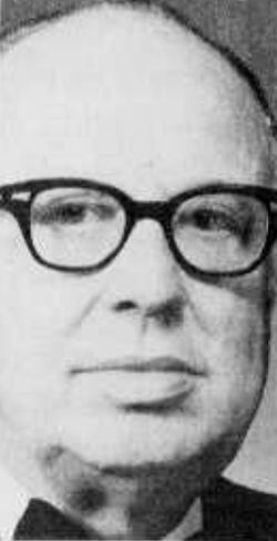
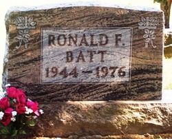
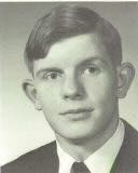
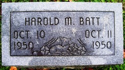
Alphonse Robert “Al” Batt
| Birth | : | 22 Mar 1907 Washington Township, Defiance County, Ohio, USA |
| Death | : | 2 Mar 1987 Defiance, Defiance County, Ohio, USA |
| Burial | : | Otahuhu Public Cemetery, Ōtāhūhū, Auckland Council, New Zealand |
| Coordinate | : | -36.9377500, 174.8432390 |
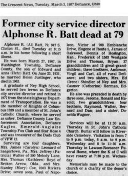
| Description | : | Former City Service Director Alphonse R. Batt Dead at 79 Alphonse R. "Al" Batt, 79, 947 South Clinton St., Defiance, died at his residence Monday morning, March 2, 1987, following a brief illness. Born in Washington Township, Defiance County, on March 27, 1907, he was the son of Anna (Hetz) and Edward Batt. On June 23, 1931, he was married to Helen Justinger, and she died April 9, 1963. A graduate of Ney High School, Mr. Batt served two terms as Defiance city service director and retired in 1977 from the Ohio Department of Transportation. A member of St.... Read More |
frequently asked questions (FAQ):
-
Where is Alphonse Robert “Al” Batt's memorial?
Alphonse Robert “Al” Batt's memorial is located at: Otahuhu Public Cemetery, Ōtāhūhū, Auckland Council, New Zealand.
-
When did Alphonse Robert “Al” Batt death?
Alphonse Robert “Al” Batt death on 2 Mar 1987 in Defiance, Defiance County, Ohio, USA
-
Where are the coordinates of the Alphonse Robert “Al” Batt's memorial?
Latitude: -36.9377500
Longitude: 174.8432390
Family Members:
Parent

Spouse
Siblings
Children

Flowers:


Nearby Cemetories:
1. Otahuhu Public Cemetery
Ōtāhūhū, Auckland Council, New Zealand
Coordinate: -36.9377500, 174.8432390
2. Holy Trinity Memorial Park
Ōtāhūhū, Auckland Council, New Zealand
Coordinate: -36.9374510, 174.8448580
3. St. Joseph and St. Joachim Catholic Cemetery
Ōtāhūhū, Auckland Council, New Zealand
Coordinate: -36.9436100, 174.8490100
4. Nixon Memorial
Ōtāhūhū, Auckland Council, New Zealand
Coordinate: -36.9499366, 174.8449909
5. St. John's Presbyterian Church Cemetery
Papatoetoe, Auckland Council, New Zealand
Coordinate: -36.9674185, 174.8598178
6. St Matthias Churchyard
Panmure, Auckland Council, New Zealand
Coordinate: -36.9053300, 174.8577200
7. St. Patrick's Roman Catholic Church Cemetery
Panmure, Auckland Council, New Zealand
Coordinate: -36.9029680, 174.8564960
8. Waikaraka Cemetery
Ōnehunga, Auckland Council, New Zealand
Coordinate: -36.9297140, 174.7967170
9. St. John's Church Cemetery
East Tamaki, Auckland Council, New Zealand
Coordinate: -36.9522250, 174.8964540
10. Onehunga Catholic Cemetery
Ōnehunga, Auckland Council, New Zealand
Coordinate: -36.9224360, 174.7884560
11. Our Lady of the Assumption Catholic Church
Ōnehunga, Auckland Council, New Zealand
Coordinate: -36.9223690, 174.7884530
12. Mangere Piriti Urupā St. James Churchyard
Mangere, Auckland Council, New Zealand
Coordinate: -36.9418970, 174.7835260
13. St. Peter's Anglican Cemetery
Ōnehunga, Auckland Council, New Zealand
Coordinate: -36.9227113, 174.7847550
14. Pakuranga Methodist Cemetery
Pakuranga, Auckland Council, New Zealand
Coordinate: -36.9054000, 174.8914900
15. Papatoetoe Cemetery
Papatoetoe, Auckland Council, New Zealand
Coordinate: -36.9893110, 174.8373530
16. Mangere Lawn Cemetery
Mangere, Auckland Council, New Zealand
Coordinate: -36.9626150, 174.7857000
17. Mangere Presbyterian Cemetery
Mangere, Auckland Council, New Zealand
Coordinate: -36.9750197, 174.7924783
18. Flat Bush Cemetery
East Tamaki, Auckland Council, New Zealand
Coordinate: -36.9563500, 174.9097100
19. Howick Historical Village
Pakuranga, Auckland Council, New Zealand
Coordinate: -36.9067680, 174.9027080
20. Manukau Memorial Gardens
Manukau, Auckland Council, New Zealand
Coordinate: -36.9944380, 174.8397300
21. Point England Presbyterian Cemetery
Point England, Auckland Council, New Zealand
Coordinate: -36.8823420, 174.8601550
22. St. Paul's Anglican Cemetery
East Tamaki, Auckland Council, New Zealand
Coordinate: -36.9615200, 174.9082000
23. St. John’s College Graveyard
Saint Johns, Auckland Council, New Zealand
Coordinate: -36.8738169, 174.8416826
24. Woodside Methodist Cemetery
Manukau, Auckland Council, New Zealand
Coordinate: -36.9929680, 174.8837860