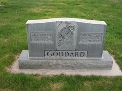
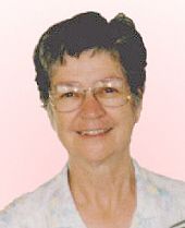
Alta Annetta Daugherty Goddard
| Birth | : | 7 Sep 1897 Mills County, Iowa, USA |
| Death | : | 11 Jan 1992 Sterling, Logan County, Colorado, USA |
| Burial | : | Timaru Cemetery, Timaru, Timaru District, New Zealand |
| Coordinate | : | -44.4122320, 171.2574270 |
| Description | : | Holyoke Enterprise, Holyoke, CO, January 16, 1992 Alta Annetta Goddard, the daughter of Joseph and Charlottie Mayberry Daugherty, was born in Mills County near Glenwood, Iowa on September 7, 1897. She died on Saturday, January 11, 1992 at the Devanshire Acres in Sterling at the age of 94. She was the youngest of three boys and seven girls. When she was a small girl, her parents moved to Colorado and homesteaded on a farm south of Sedgwick. She received her education at a rural country school. Her father died when she was young. On March 19, 1919 she married Glenn Goddard at Holyoke,... Read More |
frequently asked questions (FAQ):
-
Where is Alta Annetta Daugherty Goddard's memorial?
Alta Annetta Daugherty Goddard's memorial is located at: Timaru Cemetery, Timaru, Timaru District, New Zealand.
-
When did Alta Annetta Daugherty Goddard death?
Alta Annetta Daugherty Goddard death on 11 Jan 1992 in Sterling, Logan County, Colorado, USA
-
Where are the coordinates of the Alta Annetta Daugherty Goddard's memorial?
Latitude: -44.4122320
Longitude: 171.2574270
Family Members:
Parent
Spouse
Siblings
Children
Flowers:
Nearby Cemetories:
1. Timaru Cemetery
Timaru, Timaru District, New Zealand
Coordinate: -44.4122320, 171.2574270
2. Salisbury Park Crematorium
Timaru, Timaru District, New Zealand
Coordinate: -44.4292400, 171.2080200
3. Pareora West Cemetery
Pareora West, Timaru District, New Zealand
Coordinate: -44.4383120, 171.1343000
4. Otaio Cemetery
Otaio, Waimate District, New Zealand
Coordinate: -44.5535220, 171.1790260
5. Whareki Cemetery
Temuka, Timaru District, New Zealand
Coordinate: -44.2558600, 171.2734500
6. Temuka Cemetery
Temuka, Timaru District, New Zealand
Coordinate: -44.2499010, 171.3014390
7. St. Mary's Church Cemetery
Esk Valley, Waimate District, New Zealand
Coordinate: -44.5244000, 171.0836000
8. Pleasant Point Cemetery
Pleasant Point, Timaru District, New Zealand
Coordinate: -44.2615490, 171.1237320
9. Burnett Family Cemetery
Cave, Timaru District, New Zealand
Coordinate: -44.3156830, 170.9457270
10. Saint Aidan's Churchyard
Geraldine, Timaru District, New Zealand
Coordinate: -44.1544420, 171.0980340
11. St David’s Anglican Churchyard
Mackenzie District, New Zealand
Coordinate: -44.1706380, 170.9887810
12. Geraldine Cemetery
Geraldine, Timaru District, New Zealand
Coordinate: -44.0982600, 171.2407000
13. Albury Cemetery
Albury, Mackenzie District, New Zealand
Coordinate: -44.2371220, 170.8736570
14. St. Anne's Churchyard
Geraldine, Timaru District, New Zealand
Coordinate: -44.0836111, 171.1994444
15. Waimate Lawn Cemetery
Waimate, Waimate District, New Zealand
Coordinate: -44.7401200, 171.0614100
16. Waimate Old Cemetery
Waimate, Waimate District, New Zealand
Coordinate: -44.7410700, 171.0601300
17. Te Waimatemate Urupā
Waimate, Waimate District, New Zealand
Coordinate: -44.7367311, 171.0277419
18. Woodbury Cemetery
Woodbury, Timaru District, New Zealand
Coordinate: -44.0360900, 171.2127000
19. Fairlie Cemetery
Fairlie, Mackenzie District, New Zealand
Coordinate: -44.1075700, 170.8301500
20. Arundel Cemetery
Arundel, Timaru District, New Zealand
Coordinate: -43.9785690, 171.2838900
21. Longbeach Estate Chapel
Longbeach, Ashburton District, New Zealand
Coordinate: -44.0941090, 171.6884504
22. Hinds Cemetery
Hinds, Ashburton District, New Zealand
Coordinate: -44.0075580, 171.5735400
23. Morven Cemetery
Morven, Waimate District, New Zealand
Coordinate: -44.8658369, 171.0852820
24. Cracroft Cemetery
Ruapuna, Ashburton District, New Zealand
Coordinate: -43.9341900, 171.2989500

