
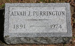
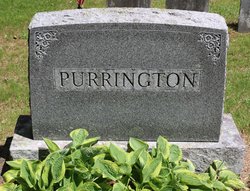
Alvah Joshua Purrington
| Birth | : | 9 Mar 1891 Buckland, Franklin County, Massachusetts, USA |
| Death | : | 24 Jun 1974 Greenfield, Franklin County, Massachusetts, USA |
| Burial | : | Brick School Cemetery, Colrain, Franklin County, USA |
| Coordinate | : | 42.6641998, -72.6660995 |
| Description | : | son of Frank G Purrington & Nannie J (Taylor) Purrington who were married on Feb 23, 1890, Alvah's mother Nannie was the dau of Alvah Taylor and Julia Ann Jerusha (Nichols) Taylor. m. Queenie L Hale died aged 83 at Franklin County Public Hospital; resident of 451 Davis Street, Greenfield; native of Buckland; World War I Navy veteran; resident of Greenfield for 61 years; retired construction worker; leaves his wife the former Queenie Hale, a son Donald A of Greenfield, a daughter Dorothy Hastings of Leyden, a sister, five grandchildren, 10 great-grandchildren and a great-great-grandchild; funeral from McCarthy funeral home, burial in... Read More |
frequently asked questions (FAQ):
-
Where is Alvah Joshua Purrington's memorial?
Alvah Joshua Purrington's memorial is located at: Brick School Cemetery, Colrain, Franklin County, USA.
-
When did Alvah Joshua Purrington death?
Alvah Joshua Purrington death on 24 Jun 1974 in Greenfield, Franklin County, Massachusetts, USA
-
Where are the coordinates of the Alvah Joshua Purrington's memorial?
Latitude: 42.6641998
Longitude: -72.6660995
Family Members:
Parent


Spouse
Siblings
Children
Flowers:


Nearby Cemetories:
1. Brick School Cemetery
Colrain, Franklin County, USA
Coordinate: 42.6641998, -72.6660995
2. Chandler Hill Cemetery
Colrain, Franklin County, USA
Coordinate: 42.6683006, -72.6832962
3. North River Cemetery
Colrain, Franklin County, USA
Coordinate: 42.6856003, -72.6917038
4. South Leyden Cemetery
Leyden, Franklin County, USA
Coordinate: 42.6831400, -72.6311200
5. Colrain West Branch Cemetery
Colrain, Franklin County, USA
Coordinate: 42.6671982, -72.7221985
6. West Leyden Cemetery
Leyden, Franklin County, USA
Coordinate: 42.7061005, -72.6572037
7. Country Farms Cemetery
Greenfield, Franklin County, USA
Coordinate: 42.6393900, -72.6165400
8. North Meadows Cemetery
Greenfield, Franklin County, USA
Coordinate: 42.6171989, -72.6333008
9. East Shelburne Cemetery
Shelburne, Franklin County, USA
Coordinate: 42.6105995, -72.6694031
10. East Hill Cemetery
Leyden, Franklin County, USA
Coordinate: 42.6931000, -72.6025009
11. Hessian Cemetery
Bernardston, Franklin County, USA
Coordinate: 42.6679174, -72.5897169
12. Beaver Meadow Cemetery
Leyden, Franklin County, USA
Coordinate: 42.7188988, -72.6183014
13. Hill Cemetery
Shelburne, Franklin County, USA
Coordinate: 42.5984344, -72.6878815
14. Arms Cemetery
Shelburne Falls, Franklin County, USA
Coordinate: 42.6166992, -72.7332993
15. Billings Cemetery
Guilford, Windham County, USA
Coordinate: 42.7353100, -72.6481800
16. Log Plain Cemetery
Greenfield, Franklin County, USA
Coordinate: 42.6378320, -72.5725800
17. Stark Cemetery
Guilford, Windham County, USA
Coordinate: 42.7402992, -72.6746979
18. Lower Meadow Cemetery
Greenfield, Franklin County, USA
Coordinate: 42.5945600, -72.6200300
19. Greenfield Hebrew Congregation Cemetery
Greenfield, Franklin County, USA
Coordinate: 42.6409410, -72.5653360
20. Groll Cemetery
Guilford, Windham County, USA
Coordinate: 42.7383400, -72.6331000
21. Bell Cemetery
Halifax, Windham County, USA
Coordinate: 42.7423800, -72.6972900
22. Henry Farm Cemetery
West Halifax, Windham County, USA
Coordinate: 42.7379712, -72.7132938
23. Baker Cemetery
Guilford, Windham County, USA
Coordinate: 42.7378006, -72.6160965
24. South Cemetery
Shelburne, Franklin County, USA
Coordinate: 42.5819016, -72.6699982