

Frank Gilbert Purrington
| Birth | : | 2 May 1866 Colrain, Franklin County, Massachusetts, USA |
| Death | : | 29 Aug 1942 Greenfield, Franklin County, Massachusetts, USA |
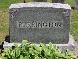
| Burial | : | Brick School Cemetery, Colrain, Franklin County, USA |
| Coordinate | : | 42.6641998, -72.6660995 |
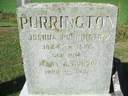
| Description | : | son of Joshua Purrington & Mary Ann (Corbin) Purrington m. Feb 23, 1890, Nannie Juliet Taylor she was the dau of Alvah Taylor and Julia Ann Jerusha (Nichols) Taylor. obit published August 31, 1942 Springfield Republican newspaper: FRANK G PURRINGTON DIES AT HOSPITAL Greenfield, Aug 30 - The funeral of Frank G Purrington, 76, of Upper Log Plain road, who died yesterday at Franklin County hospital, will take place tomorrow at 3 p.m. at the C. E. McCarthy funeral home with burial to be in Brick cemetery at East Colrain. Born at Colrain on May 2, 1866, he was the son of Joshua and Mary Ann... Read More |
frequently asked questions (FAQ):
-
Where is Frank Gilbert Purrington's memorial?
Frank Gilbert Purrington's memorial is located at: Brick School Cemetery, Colrain, Franklin County, USA.
-
When did Frank Gilbert Purrington death?
Frank Gilbert Purrington death on 29 Aug 1942 in Greenfield, Franklin County, Massachusetts, USA
-
Where are the coordinates of the Frank Gilbert Purrington's memorial?
Latitude: 42.6641998
Longitude: -72.6660995
Family Members:
Parent

Spouse

Siblings


Children
Flowers:


Nearby Cemetories:
1. Brick School Cemetery
Colrain, Franklin County, USA
Coordinate: 42.6641998, -72.6660995
2. Chandler Hill Cemetery
Colrain, Franklin County, USA
Coordinate: 42.6683006, -72.6832962
3. North River Cemetery
Colrain, Franklin County, USA
Coordinate: 42.6856003, -72.6917038
4. South Leyden Cemetery
Leyden, Franklin County, USA
Coordinate: 42.6831400, -72.6311200
5. Colrain West Branch Cemetery
Colrain, Franklin County, USA
Coordinate: 42.6671982, -72.7221985
6. West Leyden Cemetery
Leyden, Franklin County, USA
Coordinate: 42.7061005, -72.6572037
7. Country Farms Cemetery
Greenfield, Franklin County, USA
Coordinate: 42.6393900, -72.6165400
8. North Meadows Cemetery
Greenfield, Franklin County, USA
Coordinate: 42.6171989, -72.6333008
9. East Shelburne Cemetery
Shelburne, Franklin County, USA
Coordinate: 42.6105995, -72.6694031
10. East Hill Cemetery
Leyden, Franklin County, USA
Coordinate: 42.6931000, -72.6025009
11. Hessian Cemetery
Bernardston, Franklin County, USA
Coordinate: 42.6679174, -72.5897169
12. Beaver Meadow Cemetery
Leyden, Franklin County, USA
Coordinate: 42.7188988, -72.6183014
13. Hill Cemetery
Shelburne, Franklin County, USA
Coordinate: 42.5984344, -72.6878815
14. Arms Cemetery
Shelburne Falls, Franklin County, USA
Coordinate: 42.6166992, -72.7332993
15. Billings Cemetery
Guilford, Windham County, USA
Coordinate: 42.7353100, -72.6481800
16. Log Plain Cemetery
Greenfield, Franklin County, USA
Coordinate: 42.6378320, -72.5725800
17. Stark Cemetery
Guilford, Windham County, USA
Coordinate: 42.7402992, -72.6746979
18. Lower Meadow Cemetery
Greenfield, Franklin County, USA
Coordinate: 42.5945600, -72.6200300
19. Greenfield Hebrew Congregation Cemetery
Greenfield, Franklin County, USA
Coordinate: 42.6409410, -72.5653360
20. Groll Cemetery
Guilford, Windham County, USA
Coordinate: 42.7383400, -72.6331000
21. Bell Cemetery
Halifax, Windham County, USA
Coordinate: 42.7423800, -72.6972900
22. Henry Farm Cemetery
West Halifax, Windham County, USA
Coordinate: 42.7379712, -72.7132938
23. Baker Cemetery
Guilford, Windham County, USA
Coordinate: 42.7378006, -72.6160965
24. South Cemetery
Shelburne, Franklin County, USA
Coordinate: 42.5819016, -72.6699982