

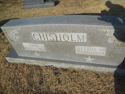
Alzada M VanPool Chisholm
| Birth | : | 27 Feb 1877 Cole County, Missouri, USA |
| Death | : | 21 Apr 1970 Russellville, Cole County, Missouri, USA |
| Burial | : | St Margaret Churchyard, Hales, South Norfolk District, England |
| Coordinate | : | 52.5109380, 1.5110840 |
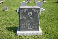
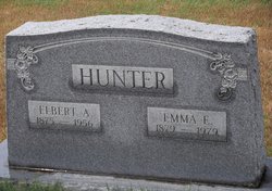
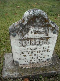
| Description | : | Obituary Post Tribune Jefferson City, Missouri Wednesday, April 22, 1970 ***** Mrs Alzada M. Chisholm, age 93 years, of Russellville, died Tuesday at her home. Mrs. Chisholm was born February 27, 1877 near Russellville, the daughter of David and Alzada West Vanpool. She was married to John Chisholm, who died in 1961. Survivors include three sisters: Mrs. Emma Hunter of Walnut, Kansas; Mrs Mary Eberhardt, Russellville, Missouri; and Mrs. Ethel Carender, 2109 Lowell Dr. Funeral services will be held at 2:00 p.m. on Friday at the Scrivner Chapel, Russellville with the Rev. John Glover officiating. Burial will be in the Enloe Cemetery. |
frequently asked questions (FAQ):
-
Where is Alzada M VanPool Chisholm's memorial?
Alzada M VanPool Chisholm's memorial is located at: St Margaret Churchyard, Hales, South Norfolk District, England.
-
When did Alzada M VanPool Chisholm death?
Alzada M VanPool Chisholm death on 21 Apr 1970 in Russellville, Cole County, Missouri, USA
-
Where are the coordinates of the Alzada M VanPool Chisholm's memorial?
Latitude: 52.5109380
Longitude: 1.5110840
Family Members:
Parent
Spouse
Siblings


Nearby Cemetories:
1. St Margaret Churchyard
Hales, South Norfolk District, England
Coordinate: 52.5109380, 1.5110840
2. St Andrews Churchyard
Raveningham, South Norfolk District, England
Coordinate: 52.5126430, 1.5323570
3. All Saints Churchyard
Kirby Cane, South Norfolk District, England
Coordinate: 52.4937500, 1.4952820
4. St Gregory Churchyard
Heckingham, South Norfolk District, England
Coordinate: 52.5350940, 1.5144710
5. Holy Trinity Churchyard
Loddon, South Norfolk District, England
Coordinate: 52.5350430, 1.4832560
6. Ss Mary and Margaret Churchyard
Norton Subcourse, North Norfolk District, England
Coordinate: 52.5324780, 1.5483860
7. Methodist Churchyard
Norton Subcourse, North Norfolk District, England
Coordinate: 52.5317630, 1.5557020
8. All Saints Churchyard
Chedgrave, South Norfolk District, England
Coordinate: 52.5409130, 1.4831200
9. St Michael Churchyard
Geldeston, South Norfolk District, England
Coordinate: 52.4759460, 1.5246070
10. St Mary's Churchyard
Ellingham, South Norfolk District, England
Coordinate: 52.4739393, 1.4827976
11. St Margaret's Churchyard
Hardley Street, South Norfolk District, England
Coordinate: 52.5522980, 1.5170630
12. All Saints Churchyard
Gillingham, South Norfolk District, England
Coordinate: 52.4753720, 1.5479546
13. St Michael's Churchyard
Broome, South Norfolk District, England
Coordinate: 52.4860360, 1.4547410
14. St Mary's Churchyard
Gillingham, South Norfolk District, England
Coordinate: 52.4750343, 1.5489500
15. Hardley Methodist Chapel
Langley with Hardley, South Norfolk District, England
Coordinate: 52.5577290, 1.4957960
16. St. Michaels's Church Cemetery
Langley with Hardley, South Norfolk District, England
Coordinate: 52.5552220, 1.4727530
17. Thorpe-next-Haddiscoe St Mathias Churchyard
Haddiscoe, South Norfolk District, England
Coordinate: 52.5261880, 1.5896380
18. St. Mary's Churchyard
Haddiscoe, South Norfolk District, England
Coordinate: 52.5153200, 1.5939300
19. St Peter's Churchyard
Mundham, South Norfolk District, England
Coordinate: 52.5303890, 1.4260120
20. St. Bartholomew's Churchyard
Shipmeadow, Waveney District, England
Coordinate: 52.4557540, 1.5046408
21. Wangford Union Workhouse Cemetery
Shipmeadow, Waveney District, England
Coordinate: 52.4540960, 1.4997050
22. All Saints Churchyard
Mettingham, Waveney District, England
Coordinate: 52.4566620, 1.4764720
23. Ditchingham Cemetery
Ditchingham, South Norfolk District, England
Coordinate: 52.4793614, 1.4307304
24. St Margaret and St Remigius Churchyard
Seething, South Norfolk District, England
Coordinate: 52.5303390, 1.4185000