
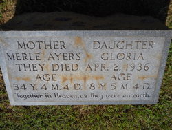
Amanda Merle DeHaven Ayers
| Birth | : | 28 Nov 1901 Hillsville, Carroll County, Virginia, USA |
| Death | : | 2 Apr 1936 |
| Burial | : | Mount Bethel Moravian Graveyard, Cana, Carroll County, USA |
| Coordinate | : | 36.6053120, -80.6272700 |
| Inscription | : | Aged 34 years 4 mos 4 days |
| Description | : | NC death certificate states she & daughter were burned in a house fire. Says house blew down in tornado and caught fire-body burned crisp. -------------- The 1936 Cordele-Greensboro tornado outbreak was a tornado outbreak that affected the Southeastern United States during April 1936. The Greensboro, North Carolina, and Cordele, Georgia, tornadoes were the deadliest spawned during the April 1-2 outbreak, which developed in three waves of tornadic activity over 14 hours, associated with the same storm system. On the evening of April 2, 1936, the Greensboro tornado left a long path of F4 damage across the south side of Greensboro, passing... Read More |
frequently asked questions (FAQ):
-
Where is Amanda Merle DeHaven Ayers's memorial?
Amanda Merle DeHaven Ayers's memorial is located at: Mount Bethel Moravian Graveyard, Cana, Carroll County, USA.
-
When did Amanda Merle DeHaven Ayers death?
Amanda Merle DeHaven Ayers death on 2 Apr 1936 in
-
Where are the coordinates of the Amanda Merle DeHaven Ayers's memorial?
Latitude: 36.6053120
Longitude: -80.6272700
Family Members:
Parent
Spouse
Siblings

Children


Nearby Cemetories:
1. Mount Bethel Moravian Graveyard
Cana, Carroll County, USA
Coordinate: 36.6053120, -80.6272700
2. Allen Cemetery
Cana, Carroll County, USA
Coordinate: 36.6155280, -80.6192210
3. Harrold Cemetery
Carroll County, USA
Coordinate: 36.6199300, -80.6219970
4. Flat Ridge Baptist Church Cemetery
Cana, Carroll County, USA
Coordinate: 36.5867470, -80.6298910
5. Westmoreland Cemetery
Cana, Carroll County, USA
Coordinate: 36.5850100, -80.6461990
6. Montgomery Family Cemetery
Ararat, Patrick County, USA
Coordinate: 36.6239760, -80.5977920
7. Gwynn Cemetery
Ararat, Patrick County, USA
Coordinate: 36.6298835, -80.6046284
8. Portis Cemetery
Ararat, Patrick County, USA
Coordinate: 36.6132460, -80.5890090
9. Gunnell Family Cemetery
Ararat, Patrick County, USA
Coordinate: 36.6034190, -80.5852510
10. Inscore Cemetery
Ararat, Patrick County, USA
Coordinate: 36.5988000, -80.5838000
11. Noonkester Family Cemetery
Ararat, Patrick County, USA
Coordinate: 36.6019990, -80.5830940
12. Speas Family Cemetery
Cana, Carroll County, USA
Coordinate: 36.5724564, -80.6447983
13. Gunnell - Bowman - Fleming Cemetery
Ararat, Patrick County, USA
Coordinate: 36.5898540, -80.5866110
14. Willis Gap Baptist Church Cemetery
Ararat, Patrick County, USA
Coordinate: 36.5925140, -80.5850250
15. Thomas Cemetery
Fancy Gap, Carroll County, USA
Coordinate: 36.6312940, -80.6592180
16. Mountain View Primitive Baptist Church Cemetery
Ararat, Patrick County, USA
Coordinate: 36.6127720, -80.5827530
17. Harrold Family Cemetery
Ararat, Patrick County, USA
Coordinate: 36.6197740, -80.5845790
18. Bear Trail Baptist Church Cemetery
Cana, Carroll County, USA
Coordinate: 36.6263910, -80.6655010
19. A.L. Jones Family Cemetery
Cana, Carroll County, USA
Coordinate: 36.5754410, -80.6561640
20. Oak Grove Baptist Church Cemetery
Cana, Carroll County, USA
Coordinate: 36.6432470, -80.6280060
21. Cana Baptist Church Cemetery
Cana, Carroll County, USA
Coordinate: 36.5920764, -80.6717347
22. Epworth United Methodist Church Cemetery
Cana, Carroll County, USA
Coordinate: 36.5736110, -80.6536110
23. Crooked Oak Moravian Church Cemetery
Cana, Carroll County, USA
Coordinate: 36.6385210, -80.6507840
24. Primitive Baptist Church Of Jesus Christ Cemetery
Cana, Carroll County, USA
Coordinate: 36.5917320, -80.6737210