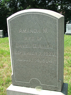
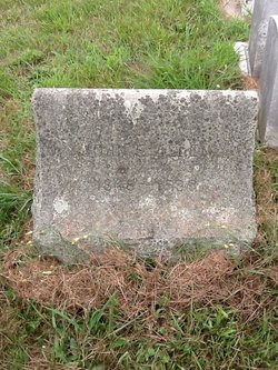
Amanda Waterman Allen Allen
| Birth | : | 7 Sep 1820 Warwick, Kent County, Rhode Island, USA |
| Death | : | 14 Aug 1904 North Kingstown, Washington County, Rhode Island, USA |
| Burial | : | Conisbrough Cemetery, Conisbrough, Metropolitan Borough of Doncaster, England |
| Coordinate | : | 53.4753700, -1.2389800 |
| Plot | : | N-108 |
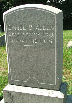
| Description | : | Married Daniel G. Allen on 26 Nov 1840 in Warwick, R.I. Information from the Ledger of Registered deaths for North Kingstown, 1904: Died in her 82nd year - accidentally fell down stairs caused brain concussion Born in Warwick to Ray Allen & Emma Burial: East Greenwich |
frequently asked questions (FAQ):
-
Where is Amanda Waterman Allen Allen's memorial?
Amanda Waterman Allen Allen's memorial is located at: Conisbrough Cemetery, Conisbrough, Metropolitan Borough of Doncaster, England.
-
When did Amanda Waterman Allen Allen death?
Amanda Waterman Allen Allen death on 14 Aug 1904 in North Kingstown, Washington County, Rhode Island, USA
-
Where are the coordinates of the Amanda Waterman Allen Allen's memorial?
Latitude: 53.4753700
Longitude: -1.2389800
Family Members:
Parent
Spouse
Children
Flowers:
Nearby Cemetories:
1. Conisbrough Cemetery
Conisbrough, Metropolitan Borough of Doncaster, England
Coordinate: 53.4753700, -1.2389800
2. St. Peter's Churchyard
Conisbrough, Metropolitan Borough of Doncaster, England
Coordinate: 53.4829890, -1.2296530
3. Hengist's Mound
Conisbrough, Metropolitan Borough of Doncaster, England
Coordinate: 53.4846490, -1.2267880
4. Denaby Cemetery
Denaby, Metropolitan Borough of Doncaster, England
Coordinate: 53.4871100, -1.2482200
5. Denaby Catholic Churchyard
Denaby, Metropolitan Borough of Doncaster, England
Coordinate: 53.4894970, -1.2446920
6. St. John The Baptist Churchyard
Hooton Roberts, Metropolitan Borough of Rotherham, England
Coordinate: 53.4683831, -1.2718687
7. St. Peter's Churchyard
Edlington, Metropolitan Borough of Doncaster, England
Coordinate: 53.4693860, -1.1992980
8. St. John's Churchyard
Cadeby, Metropolitan Borough of Doncaster, England
Coordinate: 53.4989370, -1.2254130
9. St. John The Baptist Churchyard
Mexborough, Metropolitan Borough of Doncaster, England
Coordinate: 53.4921040, -1.2783660
10. St. John the Baptist Church
Edlington, Metropolitan Borough of Doncaster, England
Coordinate: 53.4852370, -1.1922630
11. St. James' Churchyard
High Melton, Metropolitan Borough of Doncaster, England
Coordinate: 53.5106490, -1.2338020
12. St. James' Churchyard
Braithwell, Metropolitan Borough of Doncaster, England
Coordinate: 53.4465700, -1.2035400
13. Mexborough Cemetery
Mexborough, Metropolitan Borough of Doncaster, England
Coordinate: 53.4995220, -1.2886400
14. St. Leonard New Churchyard
Thrybergh, Metropolitan Borough of Rotherham, England
Coordinate: 53.4533300, -1.2916900
15. Edlington Cemetery
Edlington, Metropolitan Borough of Doncaster, England
Coordinate: 53.4927440, -1.1810370
16. St. Thomas' Churchyard Extension
Kilnhurst, Metropolitan Borough of Rotherham, England
Coordinate: 53.4723700, -1.3072300
17. St Leonard Old Churchyard
Thrybergh, Metropolitan Borough of Rotherham, England
Coordinate: 53.4540200, -1.2976200
18. Butterfields Memorial Garden
Swinton, Metropolitan Borough of Rotherham, England
Coordinate: 53.4876084, -1.3080726
19. Quaker Burial Ground
Warmsworth, Metropolitan Borough of Doncaster, England
Coordinate: 53.4994820, -1.1784890
20. St. John the Baptist Churchyard
Adwick-on-Dearne, Metropolitan Borough of Doncaster, England
Coordinate: 53.5080520, -1.2924120
21. St. Mary's Churchyard
Sprotbrough, Metropolitan Borough of Doncaster, England
Coordinate: 53.5122280, -1.1878590
22. St. Peter's Churchyard
Warmsworth, Metropolitan Borough of Doncaster, England
Coordinate: 53.5004220, -1.1679401
23. Warmsworth Cemetery
Warmsworth, Metropolitan Borough of Doncaster, England
Coordinate: 53.5056631, -1.1736180
24. St Margaret Churchyard
Swinton, Metropolitan Borough of Rotherham, England
Coordinate: 53.4890470, -1.3202140

