

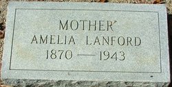
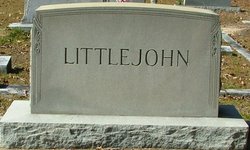
Amelia Lanford Littlejohn
| Birth | : | 10 Jul 1870 Laurens County, South Carolina, USA |
| Death | : | 27 Sep 1943 Greenwood, Laurens County, South Carolina, USA |
| Burial | : | Mound Cemetery, Downing, Dunn County, USA |
| Coordinate | : | 45.0466995, -92.1166992 |
frequently asked questions (FAQ):
-
Where is Amelia Lanford Littlejohn's memorial?
Amelia Lanford Littlejohn's memorial is located at: Mound Cemetery, Downing, Dunn County, USA.
-
When did Amelia Lanford Littlejohn death?
Amelia Lanford Littlejohn death on 27 Sep 1943 in Greenwood, Laurens County, South Carolina, USA
-
Where are the coordinates of the Amelia Lanford Littlejohn's memorial?
Latitude: 45.0466995
Longitude: -92.1166992
Family Members:
Parent

Spouse

Siblings
Children
Flowers:


Nearby Cemetories:
1. Mound Cemetery
Downing, Dunn County, USA
Coordinate: 45.0466995, -92.1166992
2. Glenwood City Cemetery
Glenwood City, St. Croix County, USA
Coordinate: 45.0533180, -92.1653137
3. Tiffany Cemetery
Boyceville, Dunn County, USA
Coordinate: 45.0416985, -92.0607986
4. Saint John the Baptist Catholic Cemetery
Glenwood City, St. Croix County, USA
Coordinate: 45.0722008, -92.1757965
5. Chimney Rock Cemetery
Boyceville, Dunn County, USA
Coordinate: 45.1048190, -92.0791700
6. Grace Lutheran Cemetery
Connorsville, Dunn County, USA
Coordinate: 45.1378000, -92.0901000
7. Saint Bridget Cemetery
Wilson, St. Croix County, USA
Coordinate: 44.9592018, -92.1778030
8. Greenwood Cemetery
Emerald, St. Croix County, USA
Coordinate: 45.0607986, -92.2583008
9. Oakwood Cemetery
Hersey, St. Croix County, USA
Coordinate: 44.9653015, -92.2133026
10. Forest Hill Cemetery
Knapp, Dunn County, USA
Coordinate: 44.9488983, -92.0475006
11. New Haven Cemetery
Connorsville, Dunn County, USA
Coordinate: 45.1507988, -92.0671997
12. Hay River Township Cemetery
Wheeler, Dunn County, USA
Coordinate: 45.0720000, -91.9504300
13. Hay River Lutheran Church Cemetery
Wheeler, Dunn County, USA
Coordinate: 45.0722008, -91.9503021
14. Saint Johns Lutheran Cemetery
Forest, St. Croix County, USA
Coordinate: 45.1348400, -92.2386300
15. Teegarden Cemetery
Knapp, Dunn County, USA
Coordinate: 44.9406013, -92.0242004
16. Immanuel Lutheran Cemetery
Forest, St. Croix County, USA
Coordinate: 45.1663300, -92.2014900
17. Sherman Cemetery
Wheeler, Dunn County, USA
Coordinate: 44.9878006, -91.9458008
18. Our Saviors Lutheran Cemetery
Wheeler, Dunn County, USA
Coordinate: 45.0381012, -91.9250031
19. Wilson Lutheran Church Cemetery
Wilson, St. Croix County, USA
Coordinate: 44.9154500, -92.1762200
20. Tramway Cemetery
Menomonie, Dunn County, USA
Coordinate: 44.9296989, -92.0006027
21. Immanuel Lutheran Cemetery
Woodville, St. Croix County, USA
Coordinate: 44.9755800, -92.2932600
22. Forest Cemetery
Forest, St. Croix County, USA
Coordinate: 45.1701200, -92.2392700
23. Lone Pine Cemetery
Woodville, St. Croix County, USA
Coordinate: 44.9603004, -92.2956009
24. Sunset Memorial Cemetery
Woodville, St. Croix County, USA
Coordinate: 44.9502411, -92.2857437