
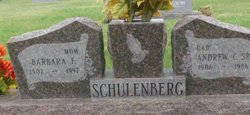
Andrew Carl “Andy” Schulenberg Sr.
| Birth | : | 12 Mar 1906 Herman, Washington County, Nebraska, USA |
| Death | : | 15 Mar 1986 Forsyth, Rosebud County, Montana, USA |
| Burial | : | Forsyth Cemetery, Forsyth, Rosebud County, USA |
| Coordinate | : | 46.2689018, -106.6528015 |
| Plot | : | 2nd Addition Section L Lot 1 Bolck E1/2 |
| Inscription | : | DAD |
| Description | : | SOURCE: Death Certificate: ''''''''''''''''''''''''''''' The Billings Gazette, MT. 3/18/1986 Tuesday Page 24 Andy Schulenberg, Sr. FORSYTH, MT. ---- Andy C. Schulenberg Sr. farmed in the Forsyth area until the late 1920's. He later owned and operated his own trucking company, hauling grains, coal, corn and beets in the 1930's. He worked for the State Highway Department until 1946 and operated the Kokomo Club, west of Forsyth until 1950. He served as undersheriff in the early 1950s and was sheriff from 1955 to 1972 when he retired, Mr. Schulenberg, 80, died Saturday in Rosebud Community Hospital. Born... Read More |
frequently asked questions (FAQ):
-
Where is Andrew Carl “Andy” Schulenberg Sr.'s memorial?
Andrew Carl “Andy” Schulenberg Sr.'s memorial is located at: Forsyth Cemetery, Forsyth, Rosebud County, USA.
-
When did Andrew Carl “Andy” Schulenberg Sr. death?
Andrew Carl “Andy” Schulenberg Sr. death on 15 Mar 1986 in Forsyth, Rosebud County, Montana, USA
-
Where are the coordinates of the Andrew Carl “Andy” Schulenberg Sr.'s memorial?
Latitude: 46.2689018
Longitude: -106.6528015
Family Members:
Parent
Spouse

Siblings
Children

Flowers:


Nearby Cemetories:
1. Forsyth Cemetery
Forsyth, Rosebud County, USA
Coordinate: 46.2689018, -106.6528015
2. Rosebud Cemetery
Rosebud, Rosebud County, USA
Coordinate: 46.2689018, -106.4381027
3. Howard Cemetery
Rosebud County, USA
Coordinate: 46.2621994, -106.9222031
4. Hathaway Cemetery
Rosebud County, USA
Coordinate: 46.2616997, -106.2185974
5. Colstrip Cemetery
Colstrip, Rosebud County, USA
Coordinate: 45.9096985, -106.6194000
6. Memorial Vale Cemetery
Hysham, Treasure County, USA
Coordinate: 46.2552986, -107.2307968
7. Bean Cemetery
Rosebud County, USA
Coordinate: 45.8535995, -106.4011002
8. Brown Cemetery
Colstrip, Rosebud County, USA
Coordinate: 45.8321991, -106.4180984
9. Lee Cemetery
Rosebud County, USA
Coordinate: 45.7792015, -106.5413971
10. Rancher Cemetery
Myers, Treasure County, USA
Coordinate: 46.2580986, -107.4197006
11. Fort Keogh Cemetery
Custer County, USA
Coordinate: 46.3800011, -105.8874969
12. Vanstel Cemetery
Rosebud County, USA
Coordinate: 46.7872009, -106.8942032
13. Calvary Cemetery
Miles City, Custer County, USA
Coordinate: 46.3816986, -105.8249969
14. Eastern Montana State Veterans Cemetery
Miles City, Custer County, USA
Coordinate: 46.3807564, -105.8246536
15. Old Calvary Cemetery
Miles City, Custer County, USA
Coordinate: 46.3807600, -105.8246500
16. Custer County Cemetery
Miles City, Custer County, USA
Coordinate: 46.3891983, -105.8264008
17. Pine Hills School Cemetery
Miles City, Custer County, USA
Coordinate: 46.4077988, -105.8167038
18. Rock Springs Cemetery
Rock Springs, Rosebud County, USA
Coordinate: 46.7847800, -106.1411500
19. Pine Crest Cemetery
Custer County, USA
Coordinate: 46.4564018, -105.7789001
20. Junction City Cemetery
Yellowstone County, USA
Coordinate: 46.1437320, -107.5493300
21. Lame Deer Cemetery
Lame Deer, Rosebud County, USA
Coordinate: 45.6264000, -106.6619034
22. Custer Cemetery
Custer, Yellowstone County, USA
Coordinate: 46.1270690, -107.5700030
23. Muddy Creek Cemetery
Muddy, Big Horn County, USA
Coordinate: 45.5741997, -106.7406006
24. Saint Labre Cemetery
Ashland, Rosebud County, USA
Coordinate: 45.6070930, -106.2836910