
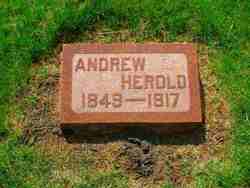
Andrew Herold
| Birth | : | 28 Mar 1849 Buffalo, Erie County, New York, USA |
| Death | : | 2 Feb 1917 Winneshiek County, Iowa, USA |
| Burial | : | Cleethorpes Cemetery, Cleethorpes, North East Lincolnshire Unitary Authority, England |
| Coordinate | : | 53.5553760, -0.0399990 |
| Description | : | Andrew Herold was born 28 Mar 1849 in Buffalo, Erie, New York. He died in Winneshiek County, Iowa on 02 Feb 1917. He married Anastasia Bouska on 25 May 1875. She is also buried at St. Clements. He was the son of Bernhard and Maria Herold. |
frequently asked questions (FAQ):
-
Where is Andrew Herold's memorial?
Andrew Herold's memorial is located at: Cleethorpes Cemetery, Cleethorpes, North East Lincolnshire Unitary Authority, England.
-
When did Andrew Herold death?
Andrew Herold death on 2 Feb 1917 in Winneshiek County, Iowa, USA
-
Where are the coordinates of the Andrew Herold's memorial?
Latitude: 53.5553760
Longitude: -0.0399990
Family Members:
Parent

Spouse
Siblings
Children
Flowers:


Nearby Cemetories:
1. Cleethorpes Cemetery
Cleethorpes, North East Lincolnshire Unitary Authority, England
Coordinate: 53.5553760, -0.0399990
2. St Peter's Church
Cleethorpes, North East Lincolnshire Unitary Authority, England
Coordinate: 53.5579756, -0.0307081
3. Holy Trinity & St Mary the Virgin Churchyard
Grimsby, North East Lincolnshire Unitary Authority, England
Coordinate: 53.5569000, -0.0541000
4. Grimsby Crematorium
Grimsby, North East Lincolnshire Unitary Authority, England
Coordinate: 53.5466260, -0.0776350
5. St Peters Churchyard
Humberston, North East Lincolnshire Unitary Authority, England
Coordinate: 53.5278300, -0.0238300
6. Scartho Road Cemetery
Grimsby, North East Lincolnshire Unitary Authority, England
Coordinate: 53.5464940, -0.0885840
7. St. James Minster and Parish Church
Grimsby, North East Lincolnshire Unitary Authority, England
Coordinate: 53.5639670, -0.0893070
8. St. Giles Churchyard
Scartho, North East Lincolnshire Unitary Authority, England
Coordinate: 53.5384200, -0.0888130
9. Holton le Clay Cemetery
Holton le Clay, East Lindsey District, England
Coordinate: 53.5074170, -0.0592630
10. Waltham Cemetery
Waltham, North East Lincolnshire Unitary Authority, England
Coordinate: 53.5155500, -0.0934700
11. St Peters Churchyard
Holton le Clay, East Lindsey District, England
Coordinate: 53.5060368, -0.0616628
12. All Saints Churchyard
Waltham, North East Lincolnshire Unitary Authority, England
Coordinate: 53.5167000, -0.0986700
13. St Michael's Churchyard
Little Coates, North East Lincolnshire Unitary Authority, England
Coordinate: 53.5631770, -0.1274160
14. St Georges Churchyard
Bradley, North East Lincolnshire Unitary Authority, England
Coordinate: 53.5429000, -0.1275800
15. St Nicolas Churchyard
Great Coates, North East Lincolnshire Unitary Authority, England
Coordinate: 53.5701890, -0.1391100
16. St Helen's Churchyard
Brigsley, North East Lincolnshire Unitary Authority, England
Coordinate: 53.4982361, -0.1099315
17. St Peter's Churchyard
Ashby cum Fenby, North East Lincolnshire Unitary Authority, England
Coordinate: 53.4903100, -0.1105200
18. St Peter & St Paul
Healing, North East Lincolnshire Unitary Authority, England
Coordinate: 53.5734480, -0.1682390
19. Laceby Cemetery
Laceby, North East Lincolnshire Unitary Authority, England
Coordinate: 53.5411890, -0.1740470
20. St Nicholas Church
Grainsby, East Lindsey District, England
Coordinate: 53.4765150, -0.0755630
21. St Lawrence Churchyard
Aylesby, North East Lincolnshire Unitary Authority, England
Coordinate: 53.5511600, -0.1858320
22. St. Martin Churchyard
East Ravendale, North East Lincolnshire Unitary Authority, England
Coordinate: 53.4793000, -0.1370044
23. St. Lawrence's Churchyard
Fulstow, East Lindsey District, England
Coordinate: 53.4599000, -0.0070000
24. Ss Peter & Paul Churchyard
Stallingborough, North East Lincolnshire Unitary Authority, England
Coordinate: 53.5895280, -0.1960590