
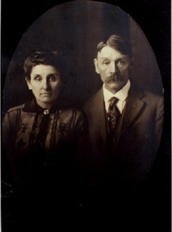
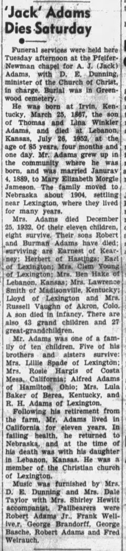
Andrew Jackson “Jack” Adams
| Birth | : | 25 Mar 1867 Estill County, Kentucky, USA |
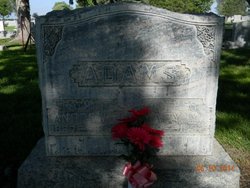
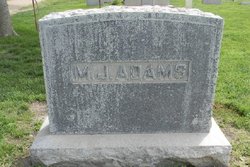
| Death | : | 1952 Lexington, Dawson County, Nebraska, USA |
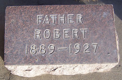
| Burial | : | Greenwood Cemetery, Lexington, Dawson County, USA |
| Coordinate | : | 40.7956467, -99.7286682 |
| Plot | : | DIV. E, BLOCK 37, LOT 2, SPACE 4. |
| Description | : | Married Mary Morgan "Morgy" Jamison on 4 Jan 1888 in Irvine, Estill, Kentucky. Parents: Thomas Washington Adams Delina Winkler Adams Siblings: Merrill Jefferson "Jeff" Adams 1865–1932 Andrew Jackson "Jack" Adams 1867–1952 **** John Thomas Adams 1869–1932 Robert Houston Adams 1871–1957 Rosanna Rosie Adams 1873–1953 William Risten Adams 1875–1893 Lillie Bell Adams 1877–1955 Alfred Daniel Adams 1879–1968 Started a feed & grain store, & livery stables in Lexington, Nebraska. He was very smart & successful in business. |
frequently asked questions (FAQ):
-
Where is Andrew Jackson “Jack” Adams's memorial?
Andrew Jackson “Jack” Adams's memorial is located at: Greenwood Cemetery, Lexington, Dawson County, USA.
-
When did Andrew Jackson “Jack” Adams death?
Andrew Jackson “Jack” Adams death on 1952 in Lexington, Dawson County, Nebraska, USA
-
Where are the coordinates of the Andrew Jackson “Jack” Adams's memorial?
Latitude: 40.7956467
Longitude: -99.7286682
Family Members:
Parent
Spouse

Siblings


Children
Flowers:


Nearby Cemetories:
1. First United Methodist Church Columbarium
Lexington, Dawson County, USA
Coordinate: 40.7810000, -99.7397000
2. Saint Anns Cemetery
Lexington, Dawson County, USA
Coordinate: 40.7789001, -99.7114029
3. Evergreen Cemetery
Lexington, Dawson County, USA
Coordinate: 40.7639008, -99.6791992
4. Mount Hope Cemetery
Dawson County, USA
Coordinate: 40.8293991, -99.6733017
5. Hewitt Cemetery
Lexington, Dawson County, USA
Coordinate: 40.8588982, -99.7769012
6. Buffalo Grove Presbyterian Church Cemetery
Buffalo, Dawson County, USA
Coordinate: 40.8721000, -99.8270000
7. Hillside Cemetery
Dawson County, USA
Coordinate: 40.8946991, -99.7869034
8. Grace Cemetery
Cozad, Dawson County, USA
Coordinate: 40.8602982, -99.8644028
9. Robb Cemetery
Smithfield, Gosper County, USA
Coordinate: 40.6710691, -99.6996001
10. Saint Johns Lutheran Cemetery
Lexington, Dawson County, USA
Coordinate: 40.9019012, -99.8458023
11. Plum Creek Massacre Cemetery
Phelps County, USA
Coordinate: 40.6726840, -99.6058220
12. Overton Cemetery
Overton, Dawson County, USA
Coordinate: 40.7317009, -99.5222015
13. Cozad Cemetery
Cozad, Dawson County, USA
Coordinate: 40.8605995, -99.9475021
14. Quakerville Cemetery
Gosper County, USA
Coordinate: 40.6189003, -99.8097000
15. Cottonwood Cemetery
Dawson County, USA
Coordinate: 40.9322014, -99.9197006
16. Saint Patricks Cemetery
Eddyville, Dawson County, USA
Coordinate: 40.9747009, -99.6093979
17. Adullam Cemetery
Bertrand, Phelps County, USA
Coordinate: 40.6265000, -99.5856000
18. Fairview Cemetery
Dawson County, USA
Coordinate: 40.7719002, -99.9955978
19. Jewell Cemetery
Sumner, Dawson County, USA
Coordinate: 40.9599991, -99.5646973
20. Rose Hill Cemetery
Dawson County, USA
Coordinate: 40.9888992, -99.8442001
21. Elwood Cemetery
Elwood, Gosper County, USA
Coordinate: 40.5999300, -99.8397300
22. Rhinehart Cemetery
Cozad, Dawson County, USA
Coordinate: 40.9599000, -99.9105000
23. Buffalo First Lutheran Cemetery Old
Buffalo, Dawson County, USA
Coordinate: 41.0100000, -99.8152000
24. Buffalo First Lutheran Cemetery New
Buffalo, Dawson County, USA
Coordinate: 41.0127000, -99.8150000