
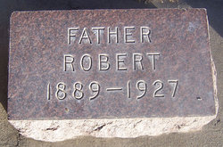
| Birth | : | 22 Jul 1889 Berea, Madison County, Kentucky, USA |
| Death | : | 30 Oct 1942 Vernonia, Columbia County, Oregon, USA |
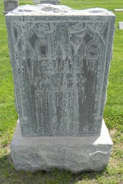
| Burial | : | Greenwood Cemetery, Lexington, Dawson County, USA |
| Coordinate | : | 40.7956467, -99.7286682 |
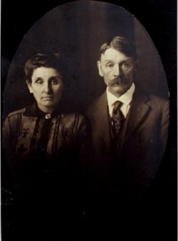
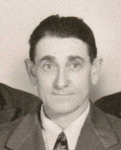
| Description | : | FORMER LEXINGTON MAN KILLED - Burnam Adams 48, was accidently killed in a lumber mill at Vernonia, Oregon, Friday October 30, 1942. He left Lexington about two years ago and up to that time he had always resided in Lexington and community. The body will be brought to Lexington for burial and will lie In state at the Emerson Mortuary on Saturday November 7. The Dawson County Herald(Lexington, Nebraska) • 5 November 1942, Thursday • Page 1 (transcribed by Wayne Ellis Brawner Jr.) • May 2022; Find-a-Grave ID 47163288 [email protected] |
frequently asked questions (FAQ):
-
Where is Burnam Adams's memorial?
Burnam Adams's memorial is located at: Greenwood Cemetery, Lexington, Dawson County, USA.
-
When did Burnam Adams death?
Burnam Adams death on 30 Oct 1942 in Vernonia, Columbia County, Oregon, USA
-
Where are the coordinates of the Burnam Adams's memorial?
Latitude: 40.7956467
Longitude: -99.7286682
Family Members:
Parent

Spouse
Siblings

Children
Flowers:


Nearby Cemetories:
1. First United Methodist Church Columbarium
Lexington, Dawson County, USA
Coordinate: 40.7810000, -99.7397000
2. Saint Anns Cemetery
Lexington, Dawson County, USA
Coordinate: 40.7789001, -99.7114029
3. Evergreen Cemetery
Lexington, Dawson County, USA
Coordinate: 40.7639008, -99.6791992
4. Mount Hope Cemetery
Dawson County, USA
Coordinate: 40.8293991, -99.6733017
5. Hewitt Cemetery
Lexington, Dawson County, USA
Coordinate: 40.8588982, -99.7769012
6. Buffalo Grove Presbyterian Church Cemetery
Buffalo, Dawson County, USA
Coordinate: 40.8721000, -99.8270000
7. Hillside Cemetery
Dawson County, USA
Coordinate: 40.8946991, -99.7869034
8. Grace Cemetery
Cozad, Dawson County, USA
Coordinate: 40.8602982, -99.8644028
9. Robb Cemetery
Smithfield, Gosper County, USA
Coordinate: 40.6710691, -99.6996001
10. Saint Johns Lutheran Cemetery
Lexington, Dawson County, USA
Coordinate: 40.9019012, -99.8458023
11. Plum Creek Massacre Cemetery
Phelps County, USA
Coordinate: 40.6726840, -99.6058220
12. Overton Cemetery
Overton, Dawson County, USA
Coordinate: 40.7317009, -99.5222015
13. Cozad Cemetery
Cozad, Dawson County, USA
Coordinate: 40.8605995, -99.9475021
14. Quakerville Cemetery
Gosper County, USA
Coordinate: 40.6189003, -99.8097000
15. Cottonwood Cemetery
Dawson County, USA
Coordinate: 40.9322014, -99.9197006
16. Saint Patricks Cemetery
Eddyville, Dawson County, USA
Coordinate: 40.9747009, -99.6093979
17. Adullam Cemetery
Bertrand, Phelps County, USA
Coordinate: 40.6265000, -99.5856000
18. Fairview Cemetery
Dawson County, USA
Coordinate: 40.7719002, -99.9955978
19. Jewell Cemetery
Sumner, Dawson County, USA
Coordinate: 40.9599991, -99.5646973
20. Rose Hill Cemetery
Dawson County, USA
Coordinate: 40.9888992, -99.8442001
21. Elwood Cemetery
Elwood, Gosper County, USA
Coordinate: 40.5999300, -99.8397300
22. Rhinehart Cemetery
Cozad, Dawson County, USA
Coordinate: 40.9599000, -99.9105000
23. Buffalo First Lutheran Cemetery Old
Buffalo, Dawson County, USA
Coordinate: 41.0100000, -99.8152000
24. Buffalo First Lutheran Cemetery New
Buffalo, Dawson County, USA
Coordinate: 41.0127000, -99.8150000