Andrew Jackson Noel
| Birth | : | 1856 Missouri, USA |
| Death | : | 21 Feb 1921 Lewistown, Fergus County, Montana, USA |
| Burial | : | Utica Cemetery, Judith Basin County, USA |
| Coordinate | : | 46.9528008, -110.0867004 |
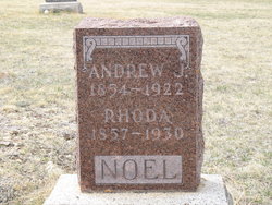
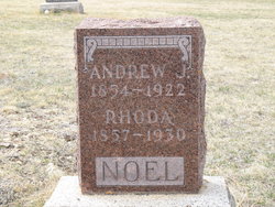
| Description | : | Montana, Death Index, 1868-2011 Name: Andrew J Noel Death Date: 21 Feb 1921 Death County: Fergus Montana, Wills and Probate Records, 1866-1965 Name: Andrew J Noel Probate Date: 2 Aug 1921 Probate Place: Judith Basin, Montana, USA Inferred Death Year: Abt 1921 Inferred Death Place: Montana, USA Case Number: 10 Item Description: Probate Case Files, Case 10-34, 1918-1930 Gravestone says 1922, but Montana Death Index and Probate both say 1921. |
frequently asked questions (FAQ):
-
Where is Andrew Jackson Noel's memorial?
Andrew Jackson Noel's memorial is located at: Utica Cemetery, Judith Basin County, USA.
-
When did Andrew Jackson Noel death?
Andrew Jackson Noel death on 21 Feb 1921 in Lewistown, Fergus County, Montana, USA
-
Where are the coordinates of the Andrew Jackson Noel's memorial?
Latitude: 46.9528008
Longitude: -110.0867004
Family Members:
Parent
Spouse
Siblings
Children
Flowers:
Nearby Cemetories:
1. Utica Cemetery
Judith Basin County, USA
Coordinate: 46.9528008, -110.0867004
2. Larson Cemetery
Judith Basin County, USA
Coordinate: 46.9968987, -110.1727982
3. Philbrook Cemetery
Hobson, Judith Basin County, USA
Coordinate: 46.9831009, -109.9558029
4. Lehigh Cemetery
Judith Basin County, USA
Coordinate: 47.0480995, -110.1766968
5. Benchland Cemetery
Judith Basin County, USA
Coordinate: 47.0839005, -110.0500031
6. Moccasin Cemetery
Moccasin, Judith Basin County, USA
Coordinate: 47.0411830, -109.9093000
7. Buffalo Cemetery
Judith Basin County, USA
Coordinate: 46.8526000, -109.8242330
8. Stanford Cemetery
Stanford, Judith Basin County, USA
Coordinate: 47.1568000, -110.2036670
9. Surprise Creek Hutterite Cemetery
Stanford, Judith Basin County, USA
Coordinate: 47.1689358, -110.3323007
10. Surprise Creek Colony Cemetery
Surprise Creek Colony, Judith Basin County, USA
Coordinate: 47.1690000, -110.3323000
11. Moore Cemetery
Moore, Fergus County, USA
Coordinate: 46.9693985, -109.6802979
12. Greer Cemetery
Stanford, Judith Basin County, USA
Coordinate: 47.0283830, -110.4878830
13. Ubet-Garneill Cemetery
Judith Basin County, USA
Coordinate: 46.7478330, -109.7800000
14. King Colony Cemetery
King Colony Ranch, Fergus County, USA
Coordinate: 47.0557000, -109.6416000
15. Strouf Pioneer Cemetery
Fergus County, USA
Coordinate: 47.2797012, -110.0481033
16. Judith Gap Cemetery
Judith Gap, Wheatland County, USA
Coordinate: 46.6676170, -109.7660030
17. Danvers Cemetery
Danvers, Fergus County, USA
Coordinate: 47.2292810, -109.7181200
18. Beaver Creek Cemetery
Lewistown, Fergus County, USA
Coordinate: 46.9510994, -109.5397034
19. Hillcrest Cemetery
Denton, Fergus County, USA
Coordinate: 47.3133011, -109.9349976
20. Barker Cemetery
Cascade County, USA
Coordinate: 47.0522003, -110.6449966
21. Coffee Creek Cemetery
Coffee Creek, Fergus County, USA
Coordinate: 47.3588420, -110.0857330
22. Deerfield Cemetery
Fergus County, USA
Coordinate: 47.2604000, -109.6819000
23. Geyser Cemetery
Geyser, Judith Basin County, USA
Coordinate: 47.2619019, -110.5064011
24. Dalgarno Family Plot
Harlowton, Wheatland County, USA
Coordinate: 46.5162164, -110.0186584


