
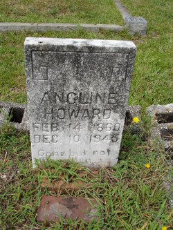
Angeline Harrison Howard
| Birth | : | 14 Feb 1860 |
| Death | : | 10 Dec 1946 Landrum, Spartanburg County, South Carolina, USA |
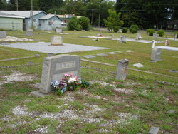
| Burial | : | Roseland Cemetery, Monticello, Jefferson County, USA |
| Coordinate | : | 30.5496998, -83.8675003 |
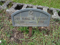
| Description | : | Wife of Wilburn D. Howard _______________________________ SOURCE: Greenville News, Page 6 DATE: Tuesday, December 11, 1945 MRS. ANGELINE HOWARD LANDRUM, Dec. 10 - Mrs. Angeline Harrison Howard, 86, died tonight at 6 o'clock at the home of a son, Rev. A.T. Howard, of Route 3, Landrum, following five weeks of declining health. She was the widow of the late W.D. Howard and the daughter of the late John and Jane Gosnell Harrison. Surviving besides her son are two daughters, Mrs. Lou Emma Lindsey and Mrs. E.A. Christopher; two sisters, Miss Sallie Harrison and Mrs. Nancy Carter; 12 grandchildren, three great-grandchildren... Read More |
frequently asked questions (FAQ):
-
Where is Angeline Harrison Howard's memorial?
Angeline Harrison Howard's memorial is located at: Roseland Cemetery, Monticello, Jefferson County, USA.
-
When did Angeline Harrison Howard death?
Angeline Harrison Howard death on 10 Dec 1946 in Landrum, Spartanburg County, South Carolina, USA
-
Where are the coordinates of the Angeline Harrison Howard's memorial?
Latitude: 30.5496998
Longitude: -83.8675003
Family Members:
Spouse

Children
Flowers:


Nearby Cemetories:
1. Roseland Cemetery
Monticello, Jefferson County, USA
Coordinate: 30.5496998, -83.8675003
2. Old City Cemetery
Monticello, Jefferson County, USA
Coordinate: 30.5492480, -83.8689960
3. Christ Episcopal Church Memorial Garden
Monticello, Jefferson County, USA
Coordinate: 30.5476330, -83.8699130
4. Texas Hill Cemetery
Monticello, Jefferson County, USA
Coordinate: 30.5599995, -83.8694000
5. Palmer Cemetery
Monticello, Jefferson County, USA
Coordinate: 30.5424030, -83.8762460
6. Mahan Gravesites
Monticello, Jefferson County, USA
Coordinate: 30.5446860, -83.8785710
7. Browns Cemetery
Monticello, Jefferson County, USA
Coordinate: 30.5524998, -83.8518982
8. Pallbearer's Cemetery
Monticello, Jefferson County, USA
Coordinate: 30.5378800, -83.8560200
9. Sneeds Cemetery
Monticello, Jefferson County, USA
Coordinate: 30.5372009, -83.8561020
10. Reichert Family Cemetery
Monticello, Jefferson County, USA
Coordinate: 30.5593050, -83.8347820
11. Byrd Cemetery
Monticello, Jefferson County, USA
Coordinate: 30.5187168, -83.8749773
12. Milton Cemetery
Jefferson County, USA
Coordinate: 30.5592003, -83.8142014
13. Hickory Hill Missionary Baptist Church Cemetery
Monticello, Jefferson County, USA
Coordinate: 30.5594020, -83.8140490
14. Macedonia Free Will Baptist Church Cemetery
Drifton, Jefferson County, USA
Coordinate: 30.5007690, -83.8787000
15. Oakfield Cemetery
Monticello, Jefferson County, USA
Coordinate: 30.5036500, -83.9044290
16. Mount Zion Cemetery
Monticello, Jefferson County, USA
Coordinate: 30.6064280, -83.8429440
17. Bellamy Cemetery
Jefferson County, USA
Coordinate: 30.5382996, -83.7968979
18. Bethel Cemetery
Jefferson County, USA
Coordinate: 30.6154080, -83.8390470
19. Scruggs Cemetery
Jefferson County, USA
Coordinate: 30.4906006, -83.8114014
20. Kinsey Cemetery
Monticello, Jefferson County, USA
Coordinate: 30.5130997, -83.7850037
21. Turnbull Cemetery
Drifton, Jefferson County, USA
Coordinate: 30.4757610, -83.9028020
22. Mount Moriah Primitive Baptist Church Cemetery
Monticello, Jefferson County, USA
Coordinate: 30.6294183, -83.8464085
23. Sweetfield Cemetery
Monticello, Jefferson County, USA
Coordinate: 30.5107100, -83.9531820
24. Walker Cemetery
Aucilla, Jefferson County, USA
Coordinate: 30.5517280, -83.7674760