

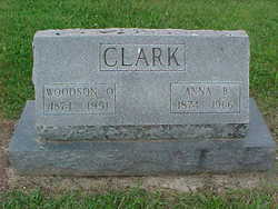
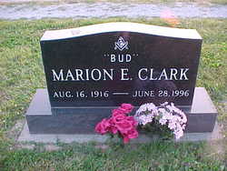
Anna Bell Croddy Clark
| Birth | : | 10 Dec 1874 Franklin County, Indiana, USA |
| Death | : | 26 Nov 1966 Danville, Hendricks County, Indiana, USA |
| Burial | : | Menorah Cemetery, Clifton, Passaic County, USA |
| Coordinate | : | 40.8418999, -74.1433029 |
| Description | : | OBITUARY, Rushville [IN] Republican, Monday, November 28, 1966: Rites Tuesday For Anna Clark Mrs. Anna B. Clark, 91, of Andersonville (R. R. 2, Rushville) died at 6:30 p.m. Saturday in Hendricks County Hospital at Danville where she had been a patient for a week. In failing health for several years, Mrs. Clark had been staying with her son, Marion E. (Bud) Clark, R. R. 1, Brownsburg. She spent most of her life in the Andersonville community and was a member of the old E.U.B. Church there. A native of Franklin County, she was born on December 10, 1874, the daughter of John and Sarah... Read More |
frequently asked questions (FAQ):
-
Where is Anna Bell Croddy Clark's memorial?
Anna Bell Croddy Clark's memorial is located at: Menorah Cemetery, Clifton, Passaic County, USA.
-
When did Anna Bell Croddy Clark death?
Anna Bell Croddy Clark death on 26 Nov 1966 in Danville, Hendricks County, Indiana, USA
-
Where are the coordinates of the Anna Bell Croddy Clark's memorial?
Latitude: 40.8418999
Longitude: -74.1433029
Family Members:
Parent

Spouse
Siblings

Children
Flowers:


Nearby Cemetories:
1. Menorah Cemetery
Clifton, Passaic County, USA
Coordinate: 40.8418999, -74.1433029
2. King Solomon Memorial Park
Clifton, Passaic County, USA
Coordinate: 40.8417015, -74.1496964
3. East Ridgelawn Cemetery
Clifton, Passaic County, USA
Coordinate: 40.8372002, -74.1389008
4. Crest Haven Memorial Park
Clifton, Passaic County, USA
Coordinate: 40.8372002, -74.1477966
5. Acquackanonk Dutch Reformed Church Burying Ground
Passaic County, USA
Coordinate: 40.8600780, -74.1264710
6. Franklin Reformed Churchyard
Nutley, Essex County, USA
Coordinate: 40.8189011, -74.1628036
7. Vincent Cemetery
Nutley, Essex County, USA
Coordinate: 40.8142014, -74.1557999
8. Brookdale Reformed Churchyard
Bloomfield, Essex County, USA
Coordinate: 40.8372002, -74.1875000
9. Saint Josephs Cemetery
Lyndhurst, Bergen County, USA
Coordinate: 40.8114014, -74.1181030
10. Vreeland Cemetery
Clifton, Passaic County, USA
Coordinate: 40.8796900, -74.1374600
11. Methodist-Episcopal Churchyard
Bloomfield, Essex County, USA
Coordinate: 40.8260440, -74.1892830
12. Immaculate Conception Cemetery
Upper Montclair, Essex County, USA
Coordinate: 40.8544006, -74.1936035
13. New Mount Zion Cemetery
Lyndhurst, Bergen County, USA
Coordinate: 40.8092003, -74.1106033
14. Hillside Cemetery
Lyndhurst, Bergen County, USA
Coordinate: 40.8091354, -74.1093597
15. Berry Lawn Cemetery
Carlstadt, Bergen County, USA
Coordinate: 40.8376700, -74.0878300
16. Mount Hebron Cemetery
Montclair, Essex County, USA
Coordinate: 40.8549995, -74.1968994
17. Saint Michael's Cemetery
South Hackensack, Bergen County, USA
Coordinate: 40.8651160, -74.0960670
18. Glendale Cemetery
Bloomfield, Essex County, USA
Coordinate: 40.8067017, -74.1766968
19. Centerville Hebrew (B'nai Jeshurun Synagogue)
Clifton, Passaic County, USA
Coordinate: 40.8808850, -74.1692910
20. Immaculate Conception Cemetery
Lodi, Bergen County, USA
Coordinate: 40.8680160, -74.0944900
21. Saint Peters Greek Catholic Cemetery
Garfield, Bergen County, USA
Coordinate: 40.8689003, -74.0939026
22. Union Congregational Church Memorial Garden
Upper Montclair, Essex County, USA
Coordinate: 40.8390200, -74.2042600
23. Saint Nicholas Cemetery
Lodi, Bergen County, USA
Coordinate: 40.8698616, -74.0940628
24. Bnai Jacob Cemetery
Lodi, Bergen County, USA
Coordinate: 40.8720436, -74.0924988