
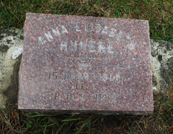
Anna Elisabeth Schumacher Huneke
| Birth | : | 15 Feb 1806 |
| Death | : | 18 Dec 1872 |
| Burial | : | St Mary Magdalene Churchyard, Clitheroe, Ribble Valley Borough, England |
| Coordinate | : | 53.8740980, -2.3903420 |
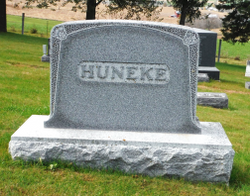
| Inscription | : | ANNA ELISABETH HUNEKE GEB 15. FEB. 1806 GEST 18. DEC. 1872 |
frequently asked questions (FAQ):
-
Where is Anna Elisabeth Schumacher Huneke's memorial?
Anna Elisabeth Schumacher Huneke's memorial is located at: St Mary Magdalene Churchyard, Clitheroe, Ribble Valley Borough, England.
-
When did Anna Elisabeth Schumacher Huneke death?
Anna Elisabeth Schumacher Huneke death on 18 Dec 1872 in
-
Where are the coordinates of the Anna Elisabeth Schumacher Huneke's memorial?
Latitude: 53.8740980
Longitude: -2.3903420
Family Members:
Spouse

Children
Flowers:


Nearby Cemetories:
1. St Mary Magdalene Churchyard
Clitheroe, Ribble Valley Borough, England
Coordinate: 53.8740980, -2.3903420
2. Trinity Methodist Churchyard
Clitheroe, Ribble Valley Borough, England
Coordinate: 53.8709060, -2.3954550
3. St. Joseph's Roman Catholic Cemetery
Clitheroe, Ribble Valley Borough, England
Coordinate: 53.8770700, -2.3960000
4. Clitheroe Cemetery
Clitheroe, Ribble Valley Borough, England
Coordinate: 53.8779250, -2.3984550
5. St James Churchyard
Clitheroe, Ribble Valley Borough, England
Coordinate: 53.8659600, -2.3922700
6. St Helen Churchyard
Waddington, Ribble Valley Borough, England
Coordinate: 53.8898700, -2.4143900
7. Christ Churchyard
Chatburn, Ribble Valley Borough, England
Coordinate: 53.8940690, -2.3515030
8. St Ambrose Churchyard
Grindleton, Ribble Valley Borough, England
Coordinate: 53.9061710, -2.3633270
9. Grindleton Methodist Cemetery
Grindleton, Ribble Valley Borough, England
Coordinate: 53.9080420, -2.3684420
10. All Hallows Churchyard
Great Mitton, Ribble Valley Borough, England
Coordinate: 53.8461500, -2.4339000
11. St. Leonard's Churchyard
Downham, Ribble Valley Borough, England
Coordinate: 53.8944340, -2.3294250
12. Queen Mary's Military Hospital Cemetery
Whalley, Ribble Valley Borough, England
Coordinate: 53.8337490, -2.4127930
13. Calderstones Hospital Cemetery
Whalley, Ribble Valley Borough, England
Coordinate: 53.8338710, -2.4147160
14. Whalley, Wiswell and Barrow Cemetery
Whalley, Ribble Valley Borough, England
Coordinate: 53.8308490, -2.4057280
15. Sawley Abbey
Sawley, Ribble Valley Borough, England
Coordinate: 53.9131920, -2.3417080
16. Saint Nicholas Parish Churchyard
Sabden, Ribble Valley Borough, England
Coordinate: 53.8346503, -2.3332764
17. Saint Mary and All Saints Churchyard
Whalley, Ribble Valley Borough, England
Coordinate: 53.8211890, -2.4078080
18. St. Joseph Roman Catholic Churchyard
Hurst Green, Ribble Valley Borough, England
Coordinate: 53.8409900, -2.4820600
19. Twiston Quaker Burial Ground
Clitheroe, Ribble Valley Borough, England
Coordinate: 53.8854210, -2.2838840
20. Stonyhurst College Burial Ground
Hurst Green, Ribble Valley Borough, England
Coordinate: 53.8403420, -2.4840310
21. Brockhall Hospital Cemetery
Brockhall Village, Ribble Valley Borough, England
Coordinate: 53.8186850, -2.4560220
22. St John the Evangelist Churchyard
Hurst Green, Ribble Valley Borough, England
Coordinate: 53.8358000, -2.4852530
23. St. John's Churchyard
Read, Ribble Valley Borough, England
Coordinate: 53.8088800, -2.3585600
24. St. Leonard Old Churchyard
Langho, Ribble Valley Borough, England
Coordinate: 53.8178590, -2.4552870