


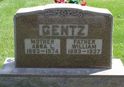
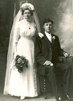
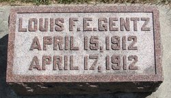
Anna Louise Christina Baltz Gentz
| Birth | : | 1 Jan 1883 Postville, Allamakee County, Iowa, USA |
| Death | : | 2 Dec 1974 Strawberry Point, Clayton County, Iowa, USA |
| Burial | : | Tracy Public Cemetery, Tracy, San Joaquin County, USA |
| Coordinate | : | 37.7251358, -121.4189453 |
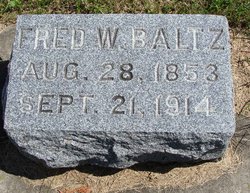
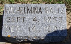
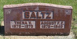
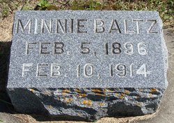
| Description | : | From the December 18, 1974, edition of the Postville (IA) Herald Services Held For Mrs. Wm. Gentz Funeral services were held Thursday, December 5 at 10:00 am at St. John Lutheran Church, Luana, for Mrs. William Gentz, who died at the Lutheran Home in Strawberry Point December 2. The Rev. Emil Reinking officiated. Burial was in the Postville Cemetery. Anna Louise Christine was the daughter of Frederick and Minnie Baltz. She was born January 1, 1883, in rural Postville. She was baptized in infancy in St. Paul Lutheran Church, Postville, and attended the rural schools in the Luana community.... Read More |
frequently asked questions (FAQ):
-
Where is Anna Louise Christina Baltz Gentz's memorial?
Anna Louise Christina Baltz Gentz's memorial is located at: Tracy Public Cemetery, Tracy, San Joaquin County, USA.
-
When did Anna Louise Christina Baltz Gentz death?
Anna Louise Christina Baltz Gentz death on 2 Dec 1974 in Strawberry Point, Clayton County, Iowa, USA
-
Where are the coordinates of the Anna Louise Christina Baltz Gentz's memorial?
Latitude: 37.7251358
Longitude: -121.4189453
Family Members:
Parent
Spouse
Siblings

Children


Flowers:


Nearby Cemetories:
1. Tracy Public Cemetery
Tracy, San Joaquin County, USA
Coordinate: 37.7251358, -121.4189453
2. Tracy Mausoleum
Tracy, San Joaquin County, USA
Coordinate: 37.7250214, -121.4150696
3. Valpico Memorial Park
Tracy, San Joaquin County, USA
Coordinate: 37.7113260, -121.4656510
4. Brichetto Tomb
San Joaquin County, USA
Coordinate: 37.6272011, -121.3871994
5. East Union Cemetery
Manteca, San Joaquin County, USA
Coordinate: 37.8114014, -121.2350006
6. Congregation of Ahavas Achim Cemetery
French Camp, San Joaquin County, USA
Coordinate: 37.8778419, -121.2753067
7. Chinese Cemetery
French Camp, San Joaquin County, USA
Coordinate: 37.8819962, -121.2805862
8. Congregation Adas Yeshuran of Stockton Cemetery
French Camp, San Joaquin County, USA
Coordinate: 37.8784065, -121.2740784
9. Park View Cemetery
Manteca, San Joaquin County, USA
Coordinate: 37.8617249, -121.2238312
10. Five Pillars Farm Cemetery
Livermore, Alameda County, USA
Coordinate: 37.7262764, -121.7105789
11. Ripon Cemetery
Ripon, San Joaquin County, USA
Coordinate: 37.7420311, -121.1238708
12. Atlanta Cemetery
Five Corners, San Joaquin County, USA
Coordinate: 37.8270035, -121.1420135
13. Grayson Cemetery
Grayson, Stanislaus County, USA
Coordinate: 37.5594559, -121.1802826
14. Thomas Lindsay Gravesite
San Joaquin County, USA
Coordinate: 37.9573110, -121.2918430
15. David Kelsey Gravesite
Stockton, San Joaquin County, USA
Coordinate: 37.9573110, -121.2918430
16. Citizens Cemetery
Stockton, San Joaquin County, USA
Coordinate: 37.9559410, -121.2769120
17. Union Cemetery
Brentwood, Contra Costa County, USA
Coordinate: 37.9103012, -121.6477966
18. Temple Israel Cemetery
Stockton, San Joaquin County, USA
Coordinate: 37.9640541, -121.2784348
19. Stockton State Hospital Cemetery
Stockton, San Joaquin County, USA
Coordinate: 37.9663110, -121.2846850
20. Saint Michaels Cemetery
Livermore, Alameda County, USA
Coordinate: 37.6797790, -121.7519150
21. San Joaquin Catholic Cemetery
Stockton, San Joaquin County, USA
Coordinate: 37.9707830, -121.2850190
22. IOOF Memory Gardens Cemetery
Livermore, Alameda County, USA
Coordinate: 37.6797850, -121.7526100
23. Casa Bonita Mausoleum
Stockton, San Joaquin County, USA
Coordinate: 37.9752340, -121.2877800
24. Stockton Woodland Mausoleum
Stockton, San Joaquin County, USA
Coordinate: 37.9762400, -121.2878000