
| Birth | : | 1836 |
| Death | : | 22 Oct 1922 Monterey County, California, USA |
| Burial | : | El Carmelo Cemetery, Pacific Grove, Monterey County, USA |
| Coordinate | : | 36.6325836, -121.9319763 |
| Plot | : | Site 3 - Lot 11 - Block 1 - Section J |
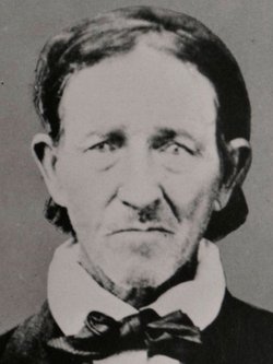
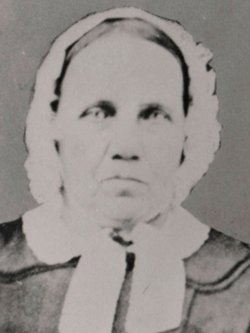
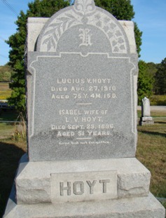
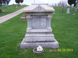
| Description | : | Her name was Anna Roverta Denman Arnold Hoyt She was married twice..first to John Harvey Arnold (1836-1880), and second to Lucius Hoyt Her parents were Zenas Hathaway Denman (1791-1871) and Jane Smith (1800-1874) California, Death Index, 1905-1939 Name: Anna R Hoyt Birth Year: abt 1836 Death Date: 22 Oct 1922 Age at Death: 86 Death Place: Monterey, California, USA Per City of Pacific Grove Ada J. Freeman is in a casket in Site 2 - Lot 11 - Block 1 - Section J (DOB: 1858, DOD: 5/19/1953). Bernard Freeman is in a casket in Site 1 -... Read More |
frequently asked questions (FAQ):
-
Where is Anna Roverta Denman Hoyt's memorial?
Anna Roverta Denman Hoyt's memorial is located at: El Carmelo Cemetery, Pacific Grove, Monterey County, USA.
-
When did Anna Roverta Denman Hoyt death?
Anna Roverta Denman Hoyt death on 22 Oct 1922 in Monterey County, California, USA
-
Where are the coordinates of the Anna Roverta Denman Hoyt's memorial?
Latitude: 36.6325836
Longitude: -121.9319763
Family Members:
Parent
Spouse
Siblings

Children
Flowers:


Nearby Cemetories:
1. El Carmelo Cemetery
Pacific Grove, Monterey County, USA
Coordinate: 36.6325836, -121.9319763
2. Saint Mary's Episcopal Church Leslie Garden
Pacific Grove, Monterey County, USA
Coordinate: 36.6211200, -121.9145800
3. Steinbeck Estate Burial Site
Pacific Grove, Monterey County, USA
Coordinate: 36.6197319, -121.9080276
4. Presidio of Monterey Cemetery
Monterey, Monterey County, USA
Coordinate: 36.6058006, -121.9151306
5. Alexis Nino Burial Site
Monterey, Monterey County, USA
Coordinate: 36.6055565, -121.8955307
6. Mission San Carlos Cemetery
Monterey, Monterey County, USA
Coordinate: 36.5956078, -121.8904190
7. San Carlos Cemetery
Monterey, Monterey County, USA
Coordinate: 36.5951881, -121.8871460
8. Monterey City Cemetery
Monterey, Monterey County, USA
Coordinate: 36.5954475, -121.8845215
9. City of Carmel Memorials
Carmel-by-the-Sea, Monterey County, USA
Coordinate: 36.5552979, -121.9203339
10. Mission Memorial Park
Seaside, Monterey County, USA
Coordinate: 36.6191635, -121.8217926
11. Carmel Mission Cemetery
Carmel-by-the-Sea, Monterey County, USA
Coordinate: 36.5430603, -121.9199600
12. California Central Coast Veterans Cemetery
Seaside, Monterey County, USA
Coordinate: 36.6371900, -121.7963600
13. Carmelite Monastery Cemetery
Monterey, Monterey County, USA
Coordinate: 36.5231400, -121.9232635
14. Saint Dunstans Episcopal Church Columbarium
Carmel Valley, Monterey County, USA
Coordinate: 36.5197330, -121.8059160
15. Whitcher Cemetery
East Garrison, Monterey County, USA
Coordinate: 36.6501730, -121.7305270
16. Church of the Good Shepherd Cemetery
Salinas, Monterey County, USA
Coordinate: 36.5413990, -121.7260410
17. Castroville Public Cemetery
Moss Landing, Monterey County, USA
Coordinate: 36.7930145, -121.7851410
18. Calvary Catholic Cemetery
Salinas, Monterey County, USA
Coordinate: 36.6880341, -121.6818085
19. Saint Pauls Episcopal Church Columbarium
Salinas, Monterey County, USA
Coordinate: 36.6588430, -121.6558850
20. Stephen Norriss Gravesite
Monterey County, USA
Coordinate: 36.8214110, -121.7601080
21. Garden of Memories
Salinas, Monterey County, USA
Coordinate: 36.6565247, -121.6384125
22. Santa Rita Chapel and Cemetery
Salinas, Monterey County, USA
Coordinate: 36.7281303, -121.6565475
23. Saint Georges Episcopal Church Columbarium
Salinas, Monterey County, USA
Coordinate: 36.7062580, -121.6440980
24. Yamato Cemetery
Salinas, Monterey County, USA
Coordinate: 36.6552811, -121.6307297