
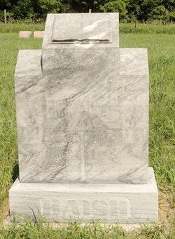
Annie Catherine Haish Snider
| Birth | : | 1870 Iowa, USA |
| Death | : | 22 Sep 1889 Custer County, Nebraska, USA |
| Burial | : | Oak Ridge Cemetery, Arcadia, DeSoto County, USA |
| Coordinate | : | 27.2264004, -81.8694000 |
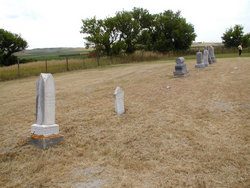
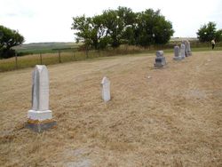
| Description | : | Snider, Annie C., (from obit: died 22 Sept 1889 - wife of John C.) (Her marker is beside John Snider's and has no dates) Snider, John, Oct 16, 1861 - July 11, 1929 Their known children: Jesse E. Snider |
frequently asked questions (FAQ):
-
Where is Annie Catherine Haish Snider's memorial?
Annie Catherine Haish Snider's memorial is located at: Oak Ridge Cemetery, Arcadia, DeSoto County, USA.
-
When did Annie Catherine Haish Snider death?
Annie Catherine Haish Snider death on 22 Sep 1889 in Custer County, Nebraska, USA
-
Where are the coordinates of the Annie Catherine Haish Snider's memorial?
Latitude: 27.2264004
Longitude: -81.8694000
Family Members:
Parent
Spouse

Siblings

Flowers:


Nearby Cemetories:
1. Oak Ridge Cemetery
Arcadia, DeSoto County, USA
Coordinate: 27.2264004, -81.8694000
2. Saint Edmund Episcopal Church Columbarium
Arcadia, DeSoto County, USA
Coordinate: 27.2176980, -81.8640790
3. Trinity United Methodist Columbarium
Arcadia, DeSoto County, USA
Coordinate: 27.2168390, -81.8640150
4. Oak Hill Cemetery
Arcadia, DeSoto County, USA
Coordinate: 27.2457730, -81.8991580
5. Kabrich Cemetery
Nocatee, DeSoto County, USA
Coordinate: 27.1698100, -81.8597000
6. Peace River Mennonite Cemetery
Arcadia, DeSoto County, USA
Coordinate: 27.2000650, -81.9284800
7. Owens Cemetery
Arcadia, DeSoto County, USA
Coordinate: 27.1833000, -81.9233017
8. Mount Olive Cemetery
Nocatee, DeSoto County, USA
Coordinate: 27.1615700, -81.8885000
9. Joshua Creek Cemetery
Arcadia, DeSoto County, USA
Coordinate: 27.1825008, -81.8028030
10. Indian Mound Cemetery
Arcadia, DeSoto County, USA
Coordinate: 27.2520220, -81.9843050
11. Pine Level Camp Grounds Cemetery
Pine Level, DeSoto County, USA
Coordinate: 27.2650394, -81.9986930
12. Coker Cemetery
Limestone, Hardee County, USA
Coordinate: 27.3514004, -81.8510971
13. Hull Cemetery
Arcadia, DeSoto County, USA
Coordinate: 27.1152992, -81.9494019
14. Gardner Cemetery
Zolfo Springs, Hardee County, USA
Coordinate: 27.3480000, -81.8029010
15. King Cemetery
Fort Ogden, DeSoto County, USA
Coordinate: 27.0869500, -81.9563100
16. Lily Cemetery
Lily, Hardee County, USA
Coordinate: 27.3643980, -81.9773480
17. Fort Ogden Cemetery
Fort Ogden, DeSoto County, USA
Coordinate: 27.0795612, -81.9651031
18. Jernigan Family Plot
Arcadia, DeSoto County, USA
Coordinate: 27.1030800, -82.0080700
19. Locklar Cemetery
Zolfo Springs, Hardee County, USA
Coordinate: 27.4012990, -81.7026930
20. Sweetwater Cemetery
Sweetwater, Hardee County, USA
Coordinate: 27.4055784, -81.7002807
21. Friendship Methodist Cemetery
Zolfo Springs, Hardee County, USA
Coordinate: 27.4553697, -81.7752567
22. Oak Grove Community Cemetery
Hardee County, USA
Coordinate: 27.4710999, -81.8600006
23. Zolfo Springs Baptist Church Cemetery
Zolfo Springs, Hardee County, USA
Coordinate: 27.4888990, -81.7914080
24. Huckeby Cemetery
Cleveland, Charlotte County, USA
Coordinate: 26.9718136, -81.9824299