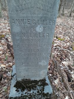
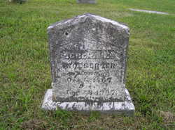
Annie Catherine Piles Liller
| Birth | : | 18 Sep 1865 Hardy County, West Virginia, USA |
| Death | : | 19 Nov 1909 Dobbin, Grant County, West Virginia, USA |
| Burial | : | Dobbin Cemetery, Garrett County, USA |
| Coordinate | : | 39.2421425, -79.4159961 |
| Plot | : | Along Potomac River, Between Gorman and Kempton |
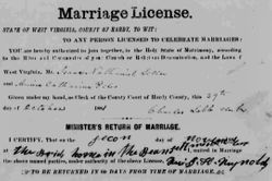
| Description | : | 3 unmarked graves are beside her.∼Married Isaac N. Liller at her parents home in Bean Settlement, Hardy County, West Virginia on Nov 2, 1881. Annie died from tuberculosis. |
frequently asked questions (FAQ):
-
Where is Annie Catherine Piles Liller's memorial?
Annie Catherine Piles Liller's memorial is located at: Dobbin Cemetery, Garrett County, USA.
-
When did Annie Catherine Piles Liller death?
Annie Catherine Piles Liller death on 19 Nov 1909 in Dobbin, Grant County, West Virginia, USA
-
Where are the coordinates of the Annie Catherine Piles Liller's memorial?
Latitude: 39.2421425
Longitude: -79.4159961
Family Members:
Parent
Spouse
Siblings
Children
Flowers:
Nearby Cemetories:
1. James M Wilkins Cemetery
Dobbin, Grant County, USA
Coordinate: 39.2388734, -79.4154218
2. Helmick
Dobbin, Grant County, USA
Coordinate: 39.2379970, -79.4156120
3. Fairview Cemetery
Oakland, Garrett County, USA
Coordinate: 39.2703018, -79.4124985
4. Bayard Cemetery
Bayard, Grant County, USA
Coordinate: 39.2728004, -79.3447037
5. Moreland Cemetery
Garrett County, USA
Coordinate: 39.2952995, -79.3703003
6. Gnegy Church Cemetery
Redhouse, Garrett County, USA
Coordinate: 39.2769012, -79.4863968
7. Old Bayard Cemetery
Grant County, USA
Coordinate: 39.2776740, -79.3435850
8. Pope Cemetery
Gorman, Garrett County, USA
Coordinate: 39.2870120, -79.3473470
9. Saint Johns Lutheran Church Cemetery
Redhouse, Garrett County, USA
Coordinate: 39.3101501, -79.4530029
10. Old Orphans Cemetery
Eglon, Preston County, USA
Coordinate: 39.2890028, -79.4940694
11. Wolfe Cemetery
Redhouse, Garrett County, USA
Coordinate: 39.3122700, -79.4760500
12. Kight Cemetery
Preston County, USA
Coordinate: 39.2218160, -79.5223730
13. Maple Spring Cemetery
Eglon, Preston County, USA
Coordinate: 39.2867012, -79.5102997
14. Oak Grove Cemetery
Gorman, Garrett County, USA
Coordinate: 39.3147011, -79.3531036
15. Beckman Cemetery
Garrett County, USA
Coordinate: 39.3293991, -79.4000015
16. Texas Cemetery
Horse Shoe Run, Preston County, USA
Coordinate: 39.2651670, -79.5270690
17. Baker Family Cemetery
Mount Storm, Grant County, USA
Coordinate: 39.2448840, -79.2968270
18. Dawson Cemetery
Eglon, Preston County, USA
Coordinate: 39.3157640, -79.4917690
19. Eglon Community Cemetery
Eglon, Preston County, USA
Coordinate: 39.3000984, -79.5139771
20. Chisholm-Nydegger Cemetery
Garrett County, USA
Coordinate: 39.3189011, -79.3403015
21. Rinehart Cemetery
Oakland, Garrett County, USA
Coordinate: 39.3359400, -79.4551800
22. Old Eglon Cemetery
Eglon, Preston County, USA
Coordinate: 39.3007622, -79.5188522
23. Lish Cemetery
Garrett County, USA
Coordinate: 39.3347015, -79.3561020
24. Wilt Cemetery
Aurora, Preston County, USA
Coordinate: 39.3196500, -79.5050600

