
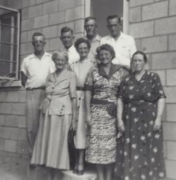
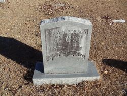

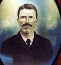
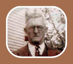
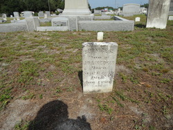
Annie Keene Coker Robison
| Birth | : | 20 Jan 1878 Turbeville, Clarendon County, South Carolina, USA |
| Death | : | 24 Aug 1956 Turbeville, Clarendon County, South Carolina, USA |
| Burial | : | El Paso Cemetery, Derby, Sedgwick County, USA |
| Coordinate | : | 37.5418015, -97.2624969 |
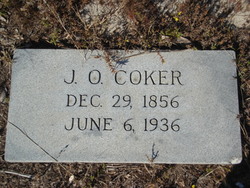
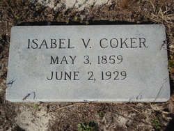
| Description | : | Daughter of Jones Coker and Isabel Smith. Married Robert Robison. |
frequently asked questions (FAQ):
-
Where is Annie Keene Coker Robison's memorial?
Annie Keene Coker Robison's memorial is located at: El Paso Cemetery, Derby, Sedgwick County, USA.
-
When did Annie Keene Coker Robison death?
Annie Keene Coker Robison death on 24 Aug 1956 in Turbeville, Clarendon County, South Carolina, USA
-
Where are the coordinates of the Annie Keene Coker Robison's memorial?
Latitude: 37.5418015
Longitude: -97.2624969
Family Members:
Parent
Spouse
Siblings

Children
Flowers:


Nearby Cemetories:
1. El Paso Cemetery
Derby, Sedgwick County, USA
Coordinate: 37.5418015, -97.2624969
2. Hillcrest Cemetery
Derby, Sedgwick County, USA
Coordinate: 37.5194435, -97.2202759
3. Prairie Home Scattering Garden
Derby, Sedgwick County, USA
Coordinate: 37.5482715, -97.1903412
4. Waco Cemetery
Waco, Sedgwick County, USA
Coordinate: 37.5242004, -97.3419037
5. Branson Cemetery
Derby, Sedgwick County, USA
Coordinate: 37.6074982, -97.2067032
6. Mulvane Cemetery
Mulvane, Sumner County, USA
Coordinate: 37.4724998, -97.2067032
7. Prairie Garden Cemetery
Peck, Sumner County, USA
Coordinate: 37.4653015, -97.3146973
8. Union Cemetery
Derby, Sedgwick County, USA
Coordinate: 37.5271988, -97.1532974
9. Roll Cemetery
Sedgwick County, USA
Coordinate: 37.5206030, -97.3739950
10. Reflection Pointe Cemetery
Wichita, Sedgwick County, USA
Coordinate: 37.6344800, -97.2264100
11. Littleton Cemetery
Gore Township, Sumner County, USA
Coordinate: 37.4498400, -97.2075500
12. Rose Hill Cemetery
Rose Hill, Butler County, USA
Coordinate: 37.5633011, -97.1177979
13. Council Hill Cemetery
Peck, Sumner County, USA
Coordinate: 37.4466600, -97.3497600
14. Mount Saint Mary Convent Cemetery
Wichita, Sedgwick County, USA
Coordinate: 37.6704000, -97.2904000
15. Greenwood Cemetery
Wichita, Sedgwick County, USA
Coordinate: 37.6067009, -97.4156036
16. Friends Cemetery
Rose Hill, Butler County, USA
Coordinate: 37.5625000, -97.0896988
17. Calvary Cemetery
Wichita, Sedgwick County, USA
Coordinate: 37.6781006, -97.2949982
18. Noel Cemetery
Clearwater, Sedgwick County, USA
Coordinate: 37.4870000, -97.4238300
19. Dunlap Cemetery
Rose Hill, Butler County, USA
Coordinate: 37.5993996, -97.0975037
20. Cornerstone Pentecostal Holiness Church
Wichita, Sedgwick County, USA
Coordinate: 37.6578700, -97.3705700
21. Seltzer Cemetery
Wichita, Sedgwick County, USA
Coordinate: 37.6652000, -97.1672700
22. East Heights United Methodist Memorial Garden
Wichita, Sedgwick County, USA
Coordinate: 37.6854100, -97.2845500
23. Saint James Episcopal Church Columbarium
Wichita, Sedgwick County, USA
Coordinate: 37.6865600, -97.2930000
24. Richland Cemetery
Douglass, Butler County, USA
Coordinate: 37.5119019, -97.0808029