
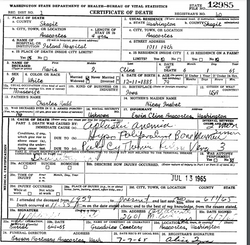
| Birth | : | 5 Jun 1901 Helena, Lewis and Clark County, Montana, USA |
| Death | : | 20 Mar 1983 Helena, Lewis and Clark County, Montana, USA |
| Burial | : | Valley Brook Cemetery, Michigan Valley, Osage County, USA |
| Coordinate | : | 38.7242279, -95.5646362 |
| Plot | : | LS 9D1 |
| Description | : | Long time Manhattan resident, Bernie Smith, 81, died in Helena Sunday morning, March 20, 1983. Bernie was born in Helena, June 5, 1901, and was adopted by the Inabnits when he was still an infant. Mr. Smith drove school bus in the area for about 43 years and at one time had the best driving record in the United States. Friends that knew him remember that he was one of the best track athletes in the 1920s. Survivors include his wife Mabel; two daughters, Pam of Helena and Donna Mae Gordon of Gatesville, Texas; a son, Bernie Jr. of Portland, Oregon; several... Read More |
frequently asked questions (FAQ):
-
Where is Archie Burnett “Burnie” Smith's memorial?
Archie Burnett “Burnie” Smith's memorial is located at: Valley Brook Cemetery, Michigan Valley, Osage County, USA.
-
When did Archie Burnett “Burnie” Smith death?
Archie Burnett “Burnie” Smith death on 20 Mar 1983 in Helena, Lewis and Clark County, Montana, USA
-
Where are the coordinates of the Archie Burnett “Burnie” Smith's memorial?
Latitude: 38.7242279
Longitude: -95.5646362
Family Members:
Parent

Spouse
Siblings
Flowers:


Nearby Cemetories:
1. Valley Brook Cemetery
Michigan Valley, Osage County, USA
Coordinate: 38.7242279, -95.5646362
2. Overbrook Cemetery
Overbrook, Osage County, USA
Coordinate: 38.7751083, -95.5487442
3. Mount Zion Cemetery
Vassar, Osage County, USA
Coordinate: 38.6796989, -95.6181030
4. Dean Cemetery
Pomona, Franklin County, USA
Coordinate: 38.7038994, -95.4781036
5. Appanoose Cemetery
Globe, Douglas County, USA
Coordinate: 38.7392006, -95.4642029
6. Pleasant Ridge Cemetery
Osage County, USA
Coordinate: 38.6492004, -95.5271988
7. Lamont Hill Cemetery
Vassar, Osage County, USA
Coordinate: 38.6392400, -95.6004600
8. Vassar Cemetery
Osage County, USA
Coordinate: 38.6408005, -95.6192017
9. Carbondale Cemetery
Carbondale, Osage County, USA
Coordinate: 38.7963982, -95.6663971
10. Salt Creek Cemetery
Osage County, USA
Coordinate: 38.6164100, -95.5875300
11. Dodder Cemetery
Baldwin City, Douglas County, USA
Coordinate: 38.7827988, -95.4452972
12. Mount Calvary Catholic Cemetery
Scranton, Osage County, USA
Coordinate: 38.7528000, -95.7055969
13. Highland Cemetery
Scranton, Osage County, USA
Coordinate: 38.7103004, -95.7099991
14. Eastview Cemetery
Quenemo, Osage County, USA
Coordinate: 38.6081009, -95.5235977
15. Ridgeway Cemetery
Osage County, USA
Coordinate: 38.8408012, -95.6066971
16. Pleasant Hill Cemetery
Centropolis, Franklin County, USA
Coordinate: 38.7243996, -95.4021988
17. Scranton Cemetery
Scranton, Osage County, USA
Coordinate: 38.7708015, -95.7221985
18. Oak Hill Cemetery
Quenemo, Osage County, USA
Coordinate: 38.5918999, -95.5333023
19. Kaub Cemetery
Centropolis, Franklin County, USA
Coordinate: 38.7172012, -95.3899994
20. Woodlawn Cemetery
Pomona, Franklin County, USA
Coordinate: 38.6100006, -95.4681015
21. Lyndon Cemetery
Lyndon, Osage County, USA
Coordinate: 38.6225014, -95.7007980
22. Rock Creek Cemetery
Douglas County, USA
Coordinate: 38.8488998, -95.4561005
23. Union Cemetery
Globe, Douglas County, USA
Coordinate: 38.7407800, -95.3713000
24. Richland Cemetery
Richland, Shawnee County, USA
Coordinate: 38.8767014, -95.5196991