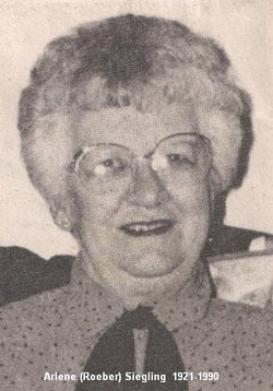
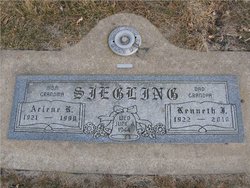
Arlene Rosena Roeber Siegling
| Birth | : | 1 Sep 1921 Tulare, Spink County, South Dakota, USA |
| Death | : | 29 Aug 1990 Redfield, Spink County, South Dakota, USA |
| Burial | : | St Thomas the Apostle Roman Catholic Cemetery, Red Bank, Northumberland County, Canada |
| Coordinate | : | 46.9435920, -65.8262620 |
| Plot | : | Division I, Block 005, Grave 099 |
| Description | : | Arlene Rosena (Roeber) Siegling 1921 - 1990 Arlene Rosena Siegling, 68, of Redfield, died Wednesday, Aug. 29, 1990, at Community Memorial Hospital. She was born Sept. 1, 1921, at Tulare to Lewis and Rosena (Middendorf) Roeber. She graduated from Tulare High School in 1939, attended Huron Business College, and worked for Farmers and Merchants Bank, Huron. She married Kenneth J. Siegling, son of John A. and Bertha A. (Mast) Siegling, June 4, 1944, at Tulare. They farmed near Burdette until 1954 when they purchased the Burdette store. In 1959 they moved to Redfield where they owned and operated Ken's Jack and... Read More |
frequently asked questions (FAQ):
-
Where is Arlene Rosena Roeber Siegling's memorial?
Arlene Rosena Roeber Siegling's memorial is located at: St Thomas the Apostle Roman Catholic Cemetery, Red Bank, Northumberland County, Canada.
-
When did Arlene Rosena Roeber Siegling death?
Arlene Rosena Roeber Siegling death on 29 Aug 1990 in Redfield, Spink County, South Dakota, USA
-
Where are the coordinates of the Arlene Rosena Roeber Siegling's memorial?
Latitude: 46.9435920
Longitude: -65.8262620
Family Members:
Parent
Spouse
Siblings
Children
Flowers:
Nearby Cemetories:
1. St Thomas the Apostle Roman Catholic Cemetery
Red Bank, Northumberland County, Canada
Coordinate: 46.9435920, -65.8262620
2. St. Stephen's Old Presbyterian Cemetery
Red Bank, Northumberland County, Canada
Coordinate: 46.9392510, -65.8217450
3. St. Stephen's United Church Cemetery
Red Bank, Northumberland County, Canada
Coordinate: 46.9387100, -65.8230800
4. Boom Road Presbyterian Cemetery
Boom Road, Northumberland County, Canada
Coordinate: 46.9530417, -65.7868678
5. Boom Road Pentecostal Cemetery
Boom Road, Northumberland County, Canada
Coordinate: 46.9517840, -65.7860330
6. Little Southwest Baptist Cemetery
Sillikers, Northumberland County, Canada
Coordinate: 46.9406500, -65.8997100
7. Back Road Baptist Cemetery
Lyttleton, Northumberland County, Canada
Coordinate: 46.9463200, -65.9022100
8. Lyttleton Pentecostal Cemetery
Lyttleton, Northumberland County, Canada
Coordinate: 46.9375200, -65.9108500
9. Whitney Old Baptist Cemetery
Whitney, Northumberland County, Canada
Coordinate: 46.9662667, -65.7212500
10. Whitney New Baptist Cemetery
Whitney, Northumberland County, Canada
Coordinate: 46.9675529, -65.7158638
11. Williamstown United Cemetery
Williamstown, Northumberland County, Canada
Coordinate: 46.9262920, -65.7087740
12. Saint Philips United Cemetery
Whitney, Northumberland County, Canada
Coordinate: 46.9720600, -65.7061500
13. Cochraneville Church Cemetery
Doyles Brook, Northumberland County, Canada
Coordinate: 46.8470000, -65.7190000
14. Saint Mark's United Church Cemetery
Quarryville, Northumberland County, Canada
Coordinate: 46.8262500, -65.7761600
15. Ferguson Presbyterian Church Cemetery
Derby, Northumberland County, Canada
Coordinate: 46.8772400, -65.6715900
16. St. James Roman Catholic Cemetery
Sevogle, Northumberland County, Canada
Coordinate: 47.0714300, -65.8239000
17. Maple Glen Cemetery
Maple Glen, Northumberland County, Canada
Coordinate: 47.0355790, -65.6941930
18. Old Saint Bridget's Roman Catholic Cemetery
Renous, Northumberland County, Canada
Coordinate: 46.8143752, -65.7963456
19. MacKinleyville-Cochranville Cemetery
McKinleyville, Northumberland County, Canada
Coordinate: 46.8650000, -65.6710000
20. MacKinley Family Cemetery
McKinleyville, Northumberland County, Canada
Coordinate: 46.8640000, -65.6710000
21. Saint Edwards Catholic Church Cemetery
Chelmsford, Northumberland County, Canada
Coordinate: 46.8670000, -65.6640000
22. St. Bridget's Catholic Church Cemetery
Renous, Northumberland County, Canada
Coordinate: 46.8089593, -65.7928838
23. St. Peter's Anglican Church Cemetery
Millerton, Northumberland County, Canada
Coordinate: 46.9000200, -65.6358200
24. Eel Ground First Nation Cemetery
Eel Ground, Northumberland County, Canada
Coordinate: 46.9652600, -65.6271700

