
| Birth | : | 25 Jul 1940 Bonesteel, Gregory County, South Dakota, USA |
| Death | : | 26 Apr 2011 Stanton, Stanton County, Nebraska, USA |
| Burial | : | Crown Hill Cemetery, Clifton Forge, Alleghany County, USA |
| Coordinate | : | 37.8139000, -79.8171997 |
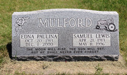
| Description | : | Funeral services for Arlo L. Mulford, age 70, of Norfolk will be held Friday, April 29, 2011 at 10:30 A.M. at Northern Heights Baptist Church in Norfolk, Nebraska with Pastor Matthew Gilmore officiating. Private family inurnment will be held at a later date at Hillcrest Memorial Park Cemetery in Norfolk. Visitation will be Thursday from 4:00 to 8:00 P.M. at Brockhaus-Howser-Fillmer Funeral Home in Norfolk. Arlo (Arnie) Lewis Mulford passed on at Stanton Health Care in Stanton, Nebraska on April 26, 2011. Arlo was born on July 25, 1940, to Samuel and Edna (Gentle) Mulford in Bonesteel, South Dakota. He... Read More |
frequently asked questions (FAQ):
-
Where is Arlo Lewis “Arnie” Mulford's memorial?
Arlo Lewis “Arnie” Mulford's memorial is located at: Crown Hill Cemetery, Clifton Forge, Alleghany County, USA.
-
When did Arlo Lewis “Arnie” Mulford death?
Arlo Lewis “Arnie” Mulford death on 26 Apr 2011 in Stanton, Stanton County, Nebraska, USA
-
Where are the coordinates of the Arlo Lewis “Arnie” Mulford's memorial?
Latitude: 37.8139000
Longitude: -79.8171997
Family Members:
Parent

Spouse
Siblings
Flowers:


Nearby Cemetories:
1. Crown Hill Cemetery
Clifton Forge, Alleghany County, USA
Coordinate: 37.8139000, -79.8171997
2. Mountain View Cemetery
Clifton Forge, Alleghany County, USA
Coordinate: 37.8135986, -79.8139038
3. Red Hill Cemetery
Clifton Forge, Alleghany County, USA
Coordinate: 37.8153648, -79.8133937
4. Walton Memorial Church Cemetery
Clifton Forge, Alleghany County, USA
Coordinate: 37.8342460, -79.7889610
5. Oakland Grove Presbyterian Church and Cemetery
Selma, Alleghany County, USA
Coordinate: 37.8018000, -79.8603000
6. Central Advent Christian Church Cemetery
Clifton Forge, Alleghany County, USA
Coordinate: 37.8286018, -79.7602997
7. Lemon Cemetery
Botetourt County, USA
Coordinate: 37.7712593, -79.7816010
8. Sharon Baptist Church Cemetery
Nicelytown, Alleghany County, USA
Coordinate: 37.8045370, -79.7428246
9. Mount Beulah Baptist Church Cemetery
Glen Wilton, Botetourt County, USA
Coordinate: 37.7545310, -79.8255680
10. Karnes Family Cemetery
Low Moor, Alleghany County, USA
Coordinate: 37.7872650, -79.8853640
11. Sunrise Cemetery
Low Moor, Alleghany County, USA
Coordinate: 37.7877220, -79.8860710
12. Mount Carmel Cemetery
Low Moor, Alleghany County, USA
Coordinate: 37.7879370, -79.8869510
13. Bethel Cemetery
Eagle Rock, Botetourt County, USA
Coordinate: 37.7487190, -79.7982530
14. Locust Bottom Cemetery
Botetourt County, USA
Coordinate: 37.7414850, -79.8145640
15. Alleghany Memorial Park
Low Moor, Alleghany County, USA
Coordinate: 37.7877998, -79.9030991
16. Wood Cemetery
Glen Wilton, Botetourt County, USA
Coordinate: 37.7358000, -79.8300080
17. Puckett Cemetery
Griffith, Alleghany County, USA
Coordinate: 37.8721000, -79.7386000
18. Haden Cemetery
Botetourt County, USA
Coordinate: 37.7228012, -79.8411026
19. Peters Family Cemetery
Millboro, Bath County, USA
Coordinate: 37.8932500, -79.7521700
20. Rosehill Cemetery
Rich Patch, Alleghany County, USA
Coordinate: 37.7380981, -79.9088974
21. Green Hill Cemetery
Valley View, Alleghany County, USA
Coordinate: 37.9007000, -79.9003000
22. Rising Mount Zion Baptist Church Cemetery
Eagle Rock, Botetourt County, USA
Coordinate: 37.6895860, -79.8029400
23. Union Chapel Cemetery
Healing Springs, Bath County, USA
Coordinate: 37.9295703, -79.8833874
24. Galatia Presbyterian Church Cemetery
Eagle Rock, Botetourt County, USA
Coordinate: 37.6855320, -79.8072950