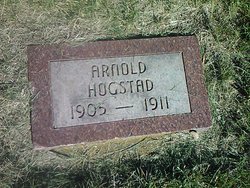
Arnold Clifton Hogstad
| Birth | : | 12 Apr 1906 Codington County, South Dakota, USA |
| Death | : | 1911 Codington County, South Dakota, USA |
| Burial | : | Shingle Hollow Holiness Church Cemetery, Rutherfordton, Rutherford County, USA |
| Coordinate | : | 35.4700130, -82.0727290 |
| Description | : | CHILD KILLED BY PITCHFORK TWO CHILDREN PLAYING TOGETHER WHEN ONE IS KILLED Watertown, Sept. 18. - Arnold Hogstad, 6-year-old son of Mr. and Mrs. Hans Hogstad of Dexter township, is dead as the result of a wound inflicted by his little sister, a few years his senior, while playing together in the haymow of their father's barn yesterday afternoon when the girl ran the tine of the pitchfork into the little boy's skull. The sister ran to the house and told her parents of the accident, and a physician was hurriedly summoned who worked over the prostrate form of the little boy, but... Read More |
frequently asked questions (FAQ):
-
Where is Arnold Clifton Hogstad's memorial?
Arnold Clifton Hogstad's memorial is located at: Shingle Hollow Holiness Church Cemetery, Rutherfordton, Rutherford County, USA.
-
When did Arnold Clifton Hogstad death?
Arnold Clifton Hogstad death on 1911 in Codington County, South Dakota, USA
-
Where are the coordinates of the Arnold Clifton Hogstad's memorial?
Latitude: 35.4700130
Longitude: -82.0727290
Family Members:
Parent
Siblings
Flowers:
Nearby Cemetories:
1. Shingle Hollow Holiness Church Cemetery
Rutherfordton, Rutherford County, USA
Coordinate: 35.4700130, -82.0727290
2. Piney Knob Baptist Church Cemetery
Rutherfordton, Rutherford County, USA
Coordinate: 35.4633100, -82.0551600
3. Gossett Family Cemetery
Rutherfordton, Rutherford County, USA
Coordinate: 35.4439400, -82.0766300
4. Pleasant Grove Baptist Church Cemetery
Rutherfordton, Rutherford County, USA
Coordinate: 35.4436000, -82.0646970
5. Melton Cemetery
Green Hill, Rutherford County, USA
Coordinate: 35.4388420, -82.0701940
6. Pine Ridge Mennonite Church Cemetery
Rutherfordton, Rutherford County, USA
Coordinate: 35.4568660, -82.0358090
7. Cedar Creek Holiness Church Cemetery
Bills Creek, Rutherford County, USA
Coordinate: 35.4855560, -82.1106620
8. Antioch Church Cemetery
Bills Creek, Rutherford County, USA
Coordinate: 35.4826780, -82.1201230
9. Pilgrims Way Baptist Church
Rutherfordton Township, Rutherford County, USA
Coordinate: 35.4266852, -82.0675485
10. Full Gospel Revival Church Cemetery
Rutherfordton, Rutherford County, USA
Coordinate: 35.4266167, -82.0888596
11. Welcome Home Baptist Church Cemetery
Gilkey, Rutherford County, USA
Coordinate: 35.5118310, -82.0482780
12. Oak Ridge Baptist Church Cemetery
Rutherford County, USA
Coordinate: 35.4260270, -82.0523350
13. Saint Johns Missionary Baptist Cemetery
Lake Lure, Rutherford County, USA
Coordinate: 35.4523926, -82.1266098
14. Hillsdale Church Cemetery
Rutherfordton, Rutherford County, USA
Coordinate: 35.4849150, -82.0134380
15. Hemphill Morgan Cemetery
Rutherford County, USA
Coordinate: 35.5197250, -82.0914320
16. Dalton Family Cemetery
Bills Creek, Rutherford County, USA
Coordinate: 35.4826320, -82.1391050
17. Montford Cove Baptist Church Cemetery
Union Mills, Rutherford County, USA
Coordinate: 35.5244110, -82.0934540
18. Bills Creek Baptist Church Cemetery
Bills Creek, Rutherford County, USA
Coordinate: 35.4514980, -82.1411210
19. Mount Nebo Baptist Cemetery
Lake Lure, Rutherford County, USA
Coordinate: 35.4502700, -82.1500200
20. Matthew Chapel AME Zion Church Cemetery
Rutherfordton, Rutherford County, USA
Coordinate: 35.4021760, -82.0736150
21. Whiteside Family Cemetery
Uree, Rutherford County, USA
Coordinate: 35.4234390, -82.1384470
22. Liberty Hill Cemetery
Rutherford County, USA
Coordinate: 35.4791985, -81.9847031
23. Little White Country Church Cemetery
Rutherfordton, Rutherford County, USA
Coordinate: 35.4487152, -81.9854279
24. Mountain Creek Baptist Church Cemetery
Rutherfordton, Rutherford County, USA
Coordinate: 35.4253006, -81.9985962


