
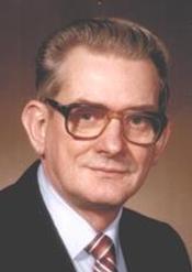
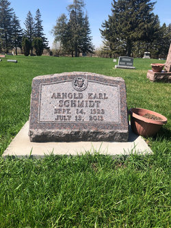
Arnold Karl “Arnie” Schmidt
| Birth | : | 14 Sep 1923 Osage, Mitchell County, Iowa, USA |
| Death | : | 13 Jul 2013 Osage, Mitchell County, Iowa, USA |
| Burial | : | Osage Cemetery, Osage, Mitchell County, USA |
| Coordinate | : | 43.2916700, -92.8201700 |
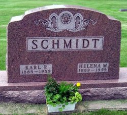
| Description | : | Arnold (Arnie) Karl Schmidt, age 89, of Osage, died Saturday, July 13, 2013, in his hometown at Faith Lutheran Home. A memorial service will be held at 10:00 a.m. Saturday, August 10, 2013, at Trinity Lutheran Church in Osage with Rev. Bruce Kaltwasser officiating. Inurnment will be in the Osage Cemetery. Following services, there will be a time for lunch and fellowship at the church. In lieu of flowers, the family suggests that memorials be directed to Trinity Lutheran Church, 402 State Street, Osage, Iowa, 50461. Arnie was born September 14, 1923, in Osage, the son of Karl P. and... Read More |
frequently asked questions (FAQ):
-
Where is Arnold Karl “Arnie” Schmidt's memorial?
Arnold Karl “Arnie” Schmidt's memorial is located at: Osage Cemetery, Osage, Mitchell County, USA.
-
When did Arnold Karl “Arnie” Schmidt death?
Arnold Karl “Arnie” Schmidt death on 13 Jul 2013 in Osage, Mitchell County, Iowa, USA
-
Where are the coordinates of the Arnold Karl “Arnie” Schmidt's memorial?
Latitude: 43.2916700
Longitude: -92.8201700
Family Members:
Parent

Siblings
Flowers:


Nearby Cemetories:
1. Osage Cemetery
Osage, Mitchell County, USA
Coordinate: 43.2916700, -92.8201700
2. Sacred Heart Cemetery
Osage, Mitchell County, USA
Coordinate: 43.2742004, -92.7917023
3. South Osage Mennonite Church Cemetery
Osage, Mitchell County, USA
Coordinate: 43.2544556, -92.7915573
4. Tucker Cemetery
Osage, Mitchell County, USA
Coordinate: 43.2494011, -92.8319016
5. Oak Grove Cemetery
Mitchell, Mitchell County, USA
Coordinate: 43.3156013, -92.8707962
6. Calvary Cemetery
Osage, Mitchell County, USA
Coordinate: 43.2238998, -92.8300018
7. Orchard Cemetery
Orchard, Mitchell County, USA
Coordinate: 43.2249985, -92.7838898
8. Dudley Cemetery
Dudley (historical), Mitchell County, USA
Coordinate: 43.2252998, -92.8743973
9. Riverview Cemetery
Saint Ansgar, Mitchell County, USA
Coordinate: 43.3430328, -92.9220200
10. Rock Creek Cemetery
Meroa, Mitchell County, USA
Coordinate: 43.2352791, -92.9225006
11. Eden Presbyterian Cemetery
Meroa, Mitchell County, USA
Coordinate: 43.2131004, -92.9103012
12. West End Cemetery
Meroa, Mitchell County, USA
Coordinate: 43.2216682, -92.9250031
13. Saint Ansgar Cemetery
Saint Ansgar, Mitchell County, USA
Coordinate: 43.3777809, -92.9094391
14. Immanuel Lutheran Cemetery
Saint Ansgar, Mitchell County, USA
Coordinate: 43.3717003, -92.9257965
15. First Lutheran Cemetery
Saint Ansgar, Mitchell County, USA
Coordinate: 43.3841705, -92.9194412
16. Liberty Cemetery
Little Cedar, Mitchell County, USA
Coordinate: 43.3856010, -92.7230988
17. Beaver Creek Cemetery
Brownville, Mitchell County, USA
Coordinate: 43.3397217, -92.6727829
18. Blakestad Cemetery
Saint Ansgar, Mitchell County, USA
Coordinate: 43.3711014, -92.9400024
19. Saint Johns Lutheran Cemetery
Rock Creek, Mitchell County, USA
Coordinate: 43.3295560, -92.9849770
20. Saint Peters Cemetery
New Haven, Mitchell County, USA
Coordinate: 43.2858315, -92.6427765
21. Saint Johns Lutheran Old Cemetery
Rock Creek, Mitchell County, USA
Coordinate: 43.3313904, -92.9897232
22. Stillwater Cemetery
Orchard, Mitchell County, USA
Coordinate: 43.2130585, -92.6780624
23. McKinley Cemetery
Saint Ansgar, Mitchell County, USA
Coordinate: 43.3906400, -92.9368300
24. Howardville Cemetery
Floyd, Floyd County, USA
Coordinate: 43.1866989, -92.7016983