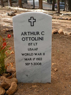
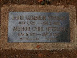
Arthur Cyril Ottolini
| Birth | : | 17 Mar 1922 San Francisco, San Francisco County, California, USA |
| Death | : | 5 Sep 2008 Santa Barbara, Santa Barbara County, California, USA |
| Burial | : | Prattville Cemetery, Prattville, Plumas County, USA |
| Coordinate | : | 40.2079340, -121.1554250 |
| Description | : | Art lived most of his life in San Francisco - he was a Cow Hollow Boy and a member of the first graduating class of George Washington High School. Art was proud to be a Boy Scout as a youth and a Scout leader through the 1950s. As a teenager, he rode and trained horses at the St. Francis Riding Academy near Golden Gate Park. Later, he rode with the Rancheros Vistadores trail ride and campout, a Santa Barbara County tradition, and he performed in the Cavalcade at the 1939 Golden Gate International Exposition on Treasure Island on San Francisco... Read More |
frequently asked questions (FAQ):
-
Where is Arthur Cyril Ottolini's memorial?
Arthur Cyril Ottolini's memorial is located at: Prattville Cemetery, Prattville, Plumas County, USA.
-
When did Arthur Cyril Ottolini death?
Arthur Cyril Ottolini death on 5 Sep 2008 in Santa Barbara, Santa Barbara County, California, USA
-
Where are the coordinates of the Arthur Cyril Ottolini's memorial?
Latitude: 40.2079340
Longitude: -121.1554250
Family Members:
Spouse
Children
Flowers:
Nearby Cemetories:
1. Prattville Cemetery
Prattville, Plumas County, USA
Coordinate: 40.2079340, -121.1554250
2. Butt Lake Cemetery
Plumas County, USA
Coordinate: 40.1236000, -121.1407700
3. Humbug Valley Cemetery
Longville, Plumas County, USA
Coordinate: 40.1492270, -121.2456680
4. Chester Cemetery
Chester, Plumas County, USA
Coordinate: 40.2777220, -121.2563870
5. Big Flat Cemetery
Seneca, Plumas County, USA
Coordinate: 40.1077995, -121.0982971
6. Greenville District Cemetery
Greenville, Plumas County, USA
Coordinate: 40.1378400, -120.9417000
7. Westwood Cemetery
Westwood, Lassen County, USA
Coordinate: 40.3182983, -120.9657974
8. Rich Bar Cemetery
Plumas County, USA
Coordinate: 40.0074260, -121.1959470
9. Stampfli Cemetery
Crescent Mills, Plumas County, USA
Coordinate: 40.1059860, -120.9109360
10. Belden Cemetery
Belden, Plumas County, USA
Coordinate: 40.0083800, -121.2527900
11. Crescent Mills Cemetery
Crescent Mills, Plumas County, USA
Coordinate: 40.0998890, -120.9095640
12. Gorbet Ranch Cemetery
Greenville, Plumas County, USA
Coordinate: 40.1179100, -120.8909300
13. Mountain Meadows Cemetery
Lassen County, USA
Coordinate: 40.3392900, -120.9191200
14. North Valley Indian Burial Grounds
Greenville, Plumas County, USA
Coordinate: 40.1455200, -120.8695700
15. George Schmidt Burial Ground
Keddie, Plumas County, USA
Coordinate: 39.9873046, -120.9768519
16. Taylorsville District Cemetery
Taylorsville, Plumas County, USA
Coordinate: 40.0740820, -120.8367200
17. Taylorsville Indian Burial Grounds
Taylorsville, Plumas County, USA
Coordinate: 40.0748050, -120.8359420
18. Meadow Valley Cemetery
Meadow Valley, Plumas County, USA
Coordinate: 39.9307050, -121.0591870
19. Stiver Cemetery
Quincy, Plumas County, USA
Coordinate: 39.9747009, -120.9300003
20. Plumas County Cemetery
Quincy, Plumas County, USA
Coordinate: 39.9486008, -120.9417038
21. Cussick McGann Cemetery
Butte Meadows, Butte County, USA
Coordinate: 40.0831870, -121.5336330
22. Quincy Cemetery
Quincy, Plumas County, USA
Coordinate: 39.9361000, -120.9297028
23. Quincy Chinese Cemetery
Quincy, Plumas County, USA
Coordinate: 39.9357770, -120.9247350
24. Sutton House Cemetery
Butte Meadows, Butte County, USA
Coordinate: 40.0828300, -121.5507200


