
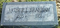
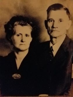
Arthur Lee Branham
| Birth | : | 15 Feb 1885 Owen County, Kentucky, USA |
| Death | : | 21 Apr 1951 Madison, Jefferson County, Indiana, USA |
| Burial | : | Cypress View Mausoleum and Crematory, San Diego, San Diego County, USA |
| Coordinate | : | 32.7050018, -117.1081009 |
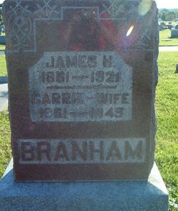
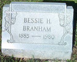
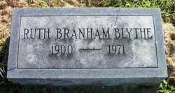
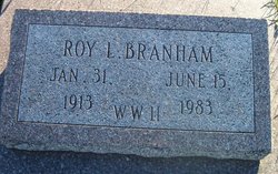
| Description | : | ______________________________________ ______________________________________ Arthur Lee Branham was the son of James Headley Branham and Carrie Laura McDonald. He married Bessie Howard on December 25, 1910. Their children: 1. Carlyle Branham born October 22, 1911. 2. Roy Lee Branham born January 31, 1913. ______________________________________ ______________________________________ Vevay Reveille Enterprise Vevay, Indiana April 26, 1951 Arthur Branham Is Claimed By Death Saturday Evening Illness of Many Years Precedes Death of Former County Farmer Arthur Branham, 65, former farm owner of Switzerland county, passed away at the Madison State Hospital aobut 8 o'clock last Saturday evening, following an illness that had extended over a period of more... Read More |
frequently asked questions (FAQ):
-
Where is Arthur Lee Branham's memorial?
Arthur Lee Branham's memorial is located at: Cypress View Mausoleum and Crematory, San Diego, San Diego County, USA.
-
When did Arthur Lee Branham death?
Arthur Lee Branham death on 21 Apr 1951 in Madison, Jefferson County, Indiana, USA
-
Where are the coordinates of the Arthur Lee Branham's memorial?
Latitude: 32.7050018
Longitude: -117.1081009
Family Members:
Parent

Spouse
Siblings

Children
Flowers:


Nearby Cemetories:
1. Cypress View Mausoleum and Crematory
San Diego, San Diego County, USA
Coordinate: 32.7050018, -117.1081009
2. Greenwood Memorial Park
San Diego, San Diego County, USA
Coordinate: 32.7057991, -117.1025009
3. Home of Peace Cemetery
San Diego, San Diego County, USA
Coordinate: 32.7052002, -117.1150970
4. Mount Hope Cemetery
San Diego, San Diego County, USA
Coordinate: 32.7111890, -117.1121660
5. Holy Cross Cemetery
San Diego, San Diego County, USA
Coordinate: 32.7168999, -117.0975037
6. Nhu Lai Thien Tu Temple Columbarium
San Diego County, USA
Coordinate: 32.7411200, -117.1084400
7. Wat Lao Boubpharam Temple Columbarium
San Diego, San Diego County, USA
Coordinate: 32.7029900, -117.0574800
8. Bum Dog Burial Site
San Diego, San Diego County, USA
Coordinate: 32.7105700, -117.1606500
9. La Vista Memorial Park
National City, San Diego County, USA
Coordinate: 32.6638985, -117.0727997
10. Saint Pauls Episcopal Cathedral Columbarium
San Diego, San Diego County, USA
Coordinate: 32.7340800, -117.1595900
11. Normal Heights United Methodist Church Columbarium
San Diego, San Diego County, USA
Coordinate: 32.7625900, -117.1186200
12. Christ Episcopal Church Memorial Garden
Coronado, San Diego County, USA
Coordinate: 32.6866970, -117.1784000
13. Beth Sarim House
San Diego, San Diego County, USA
Coordinate: 32.7712330, -117.0992590
14. First United Methodist Church Memorial Garden
San Diego, San Diego County, USA
Coordinate: 32.7674040, -117.1425440
15. First Unitarian Universalist Church of San Diego
San Diego, San Diego County, USA
Coordinate: 32.7535730, -117.1664870
16. Calvary Cemetery
San Diego, San Diego County, USA
Coordinate: 32.7489014, -117.1766968
17. Glen Abbey Memorial Park
Bonita, San Diego County, USA
Coordinate: 32.6529620, -117.0480180
18. Anton Sonka Burial Site
Lemon Grove, San Diego County, USA
Coordinate: 32.7401240, -117.0319330
19. Mission San Diego de Alcala Cemetery
San Diego, San Diego County, USA
Coordinate: 32.7858009, -117.1103973
20. El Campo Santo Cemetery
San Diego, San Diego County, USA
Coordinate: 32.7514000, -117.1922989
21. Saint John's Episcopal Church Memorial Garden
Chula Vista, San Diego County, USA
Coordinate: 32.6275600, -117.0656300
22. Presidio Hill Cemetery
Old Town San Diego, San Diego County, USA
Coordinate: 32.7592960, -117.1949920
23. Saint Dunstans Episcopal Church Columbarium
San Diego, San Diego County, USA
Coordinate: 32.7963070, -117.0498750
24. United Church of Christ Columbarium
La Mesa, San Diego County, USA
Coordinate: 32.7864100, -117.0184600