
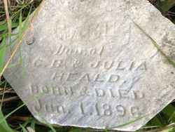
| Birth | : | 15 Nov 1881 Scotland County, Missouri, USA |
| Death | : | 15 Jul 1884 Scotland County, Missouri, USA |
| Burial | : | Heald Cemetery, Scotland County, USA |
| Coordinate | : | 40.6032982, -91.9475021 |
| Description | : | aged 02Y 08M 00D |
frequently asked questions (FAQ):
-
Where is Arthur W Heald's memorial?
Arthur W Heald's memorial is located at: Heald Cemetery, Scotland County, USA.
-
When did Arthur W Heald death?
Arthur W Heald death on 15 Jul 1884 in Scotland County, Missouri, USA
-
Where are the coordinates of the Arthur W Heald's memorial?
Latitude: 40.6032982
Longitude: -91.9475021
Family Members:
Parent
Siblings

Flowers:


Nearby Cemetories:
1. Heald Cemetery
Scotland County, USA
Coordinate: 40.6032982, -91.9475021
2. Hanan Family Cemetery
Luray, Clark County, USA
Coordinate: 40.5843658, -91.9429626
3. Miller Cemetery
Mount Sterling, Van Buren County, USA
Coordinate: 40.6209578, -91.9312522
4. W. H. Todd Family Cemetery
Luray, Clark County, USA
Coordinate: 40.5985413, -91.9186325
5. Ashbury Methodist Episcopal Church Cemetery
Luray, Clark County, USA
Coordinate: 40.5774231, -91.9375839
6. Allphin Cemetery
Scotland County, USA
Coordinate: 40.5786018, -91.9664001
7. Harness Cemetery
Mount Sterling, Van Buren County, USA
Coordinate: 40.6232986, -91.9191971
8. Wiley Cemetery
Mount Sterling, Van Buren County, USA
Coordinate: 40.6369019, -91.9586029
9. Bibb Cemetery
Scotland County, USA
Coordinate: 40.5677986, -91.9621964
10. Davis Cemetery
Scotland County, USA
Coordinate: 40.5736008, -91.9783020
11. Blackledge Cemetery
Mount Sterling, Van Buren County, USA
Coordinate: 40.6094017, -91.8949966
12. Jones Cemetery
Mount Sterling, Van Buren County, USA
Coordinate: 40.6450005, -91.9206009
13. Phillips Cemetery
Van Buren County, USA
Coordinate: 40.6472015, -91.9922028
14. Mantonye Cemetery
Van Buren County, USA
Coordinate: 40.6264000, -92.0248000
15. Upton Cemetery
Cantril, Van Buren County, USA
Coordinate: 40.6074030, -92.0338380
16. Seaman Cemetery
Mount Sterling, Van Buren County, USA
Coordinate: 40.6715000, -91.9449800
17. Anderson Cemetery
Mount Sterling, Van Buren County, USA
Coordinate: 40.6167001, -91.8585027
18. Wolf Cemetery
Mount Sterling, Van Buren County, USA
Coordinate: 40.6603012, -91.8921967
19. Prospect Grove Cemetery
Scotland County, USA
Coordinate: 40.5346985, -91.9841995
20. Mount Moriah Cemetery
Azen, Scotland County, USA
Coordinate: 40.5422800, -92.0083700
21. Prall Cemetery
Keosauqua, Van Buren County, USA
Coordinate: 40.6817017, -91.9822006
22. Kaiser Cemetery
Cantril, Van Buren County, USA
Coordinate: 40.6617600, -92.0249800
23. Gorgas Cemetery
Scotland County, USA
Coordinate: 40.5256004, -91.9891968
24. White Cemetery
Keosauqua, Van Buren County, USA
Coordinate: 40.6878700, -91.9584200