
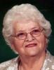
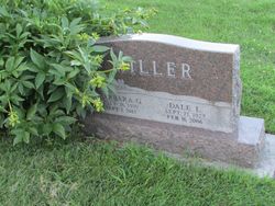

Barbara G. Gaines Miller
| Birth | : | 26 Jul 1930 Maryville, Nodaway County, Missouri, USA |
| Death | : | 2 Sep 2013 Lee's Summit, Jackson County, Missouri, USA |
| Burial | : | Goodland Cemetery, Goodland, Sherman County, USA |
| Coordinate | : | 39.3652992, -101.7138977 |
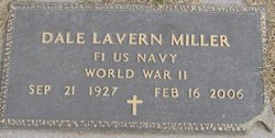
| Description | : | Barbara Mae (Gaines) Miller, 83, formerly of Maryville, Missouri, died Monday, September 2, 2013, at St. Luke's East, Lee's Summit, Missouri. Barbara was born July 26, 1930, in Maryville to Willard Monroe and Mabel Mae (Craig) Gaines. She married Dale Miller on May 26, 1949, in Maryville, Missouri. He preceded Barbara in death on February 16, 2006. A graduate of Junction City, Kansas High School, she also attended Northwest Missouri State University . Barbara was a homemaker and a member of the First Christian Church and Christian Women's Fellowship, Maryville. She also had been a member of the... Read More |
frequently asked questions (FAQ):
-
Where is Barbara G. Gaines Miller's memorial?
Barbara G. Gaines Miller's memorial is located at: Goodland Cemetery, Goodland, Sherman County, USA.
-
When did Barbara G. Gaines Miller death?
Barbara G. Gaines Miller death on 2 Sep 2013 in Lee's Summit, Jackson County, Missouri, USA
-
Where are the coordinates of the Barbara G. Gaines Miller's memorial?
Latitude: 39.3652992
Longitude: -101.7138977
Family Members:
Spouse
Children

Flowers:


Nearby Cemetories:
1. Goodland Cemetery
Goodland, Sherman County, USA
Coordinate: 39.3652992, -101.7138977
2. Harmony Cemetery
Sherman County, USA
Coordinate: 39.4236107, -101.6921158
3. Whisler Cemetery
Goodland, Sherman County, USA
Coordinate: 39.2785988, -101.7457962
4. Frerichs Cemetery
Goodland, Sherman County, USA
Coordinate: 39.2792015, -101.6511002
5. Edson Cemetery
Edson, Sherman County, USA
Coordinate: 39.3375600, -101.5587800
6. New Liberty Cemetery
Ruleton, Sherman County, USA
Coordinate: 39.4374400, -101.8727700
7. Shermanville Cemetery
Edson, Sherman County, USA
Coordinate: 39.5111084, -101.5782242
8. Mennonite Cemetery
Edson, Sherman County, USA
Coordinate: 39.2069016, -101.5980988
9. Hollenbeck Cemetery
Edson, Sherman County, USA
Coordinate: 39.3736000, -101.4656982
10. Fairview Cemetery
Sherman County, USA
Coordinate: 39.3736000, -101.4653015
11. Freeland Cemetery
Sherman County, USA
Coordinate: 39.4678001, -101.4552994
12. Kanorado Catholic Cemetery
Sherman County, USA
Coordinate: 39.2944450, -102.0087891
13. Brewster Cemetery
Sherman County, USA
Coordinate: 39.3605995, -101.3917007
14. Kanorado Cemetery
Kanorado, Sherman County, USA
Coordinate: 39.3427400, -102.0419900
15. Fairview Cemetery
Wallace County, USA
Coordinate: 39.1264000, -101.8681030
16. Lawn Ridge Cemetery
Saint Francis, Cheyenne County, USA
Coordinate: 39.6268997, -101.7882996
17. Sunnyside Cemetery
Bird City, Cheyenne County, USA
Coordinate: 39.5827800, -101.5109900
18. Lava Cemetery
Sherman County, USA
Coordinate: 39.2001830, -101.4337300
19. Saint Pauls Lutheran Cemetery
Wheeler, Cheyenne County, USA
Coordinate: 39.6389000, -101.6937000
20. North Township Cemetery
Sharon Springs, Wallace County, USA
Coordinate: 39.0878360, -101.7389010
21. Fairview Cemetery
Brewster, Thomas County, USA
Coordinate: 39.5260530, -101.3799140
22. Beaver Valley Cemetery
Kit Carson County, USA
Coordinate: 39.4625015, -102.0899963
23. Brownville Cemetery
Brownville, Thomas County, USA
Coordinate: 39.1933660, -101.3727160
24. Gritzland Cemetery
Bird City, Cheyenne County, USA
Coordinate: 39.6118800, -101.4507500