
| Birth | : | 25 Jan 1928 Osage, Mitchell County, Iowa, USA |
| Death | : | 9 Feb 2002 Franktown, Douglas County, Colorado, USA |
| Burial | : | Osage Cemetery, Osage, Mitchell County, USA |
| Coordinate | : | 43.2916700, -92.8201700 |
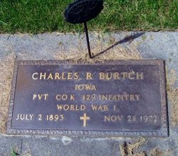
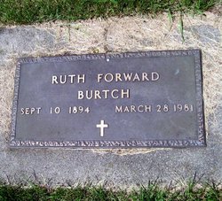
| Description | : | Barbara Oxenford Mrs. John (Barbara) Oxenford, age 74, of Rifle, Colorado, died on Saturday, February 9, 2002. Inurnment will be in the Osage Cemetery at a later date. She was born on January 25, 1928, to Charles R. and Ruth (Forward) Burtch of Osage. Barbara was preceded in death by her parents. Those that survive her include her husband, John; three children, John Thomas, Robert and Deborah Ruth; fourteen grandchildren; two sisters, Beth Lothringer and husband, Jim of LaMesa, California and Dorothy Anderson and husband, Robert of Williams, Arizona; and a cousin, Maurine Hudson of Osage. |
frequently asked questions (FAQ):
-
Where is Barbara Ruth Burtch Oxenford's memorial?
Barbara Ruth Burtch Oxenford's memorial is located at: Osage Cemetery, Osage, Mitchell County, USA.
-
When did Barbara Ruth Burtch Oxenford death?
Barbara Ruth Burtch Oxenford death on 9 Feb 2002 in Franktown, Douglas County, Colorado, USA
-
Where are the coordinates of the Barbara Ruth Burtch Oxenford's memorial?
Latitude: 43.2916700
Longitude: -92.8201700
Family Members:
Parent
Spouse

Flowers:


Nearby Cemetories:
1. Osage Cemetery
Osage, Mitchell County, USA
Coordinate: 43.2916700, -92.8201700
2. Sacred Heart Cemetery
Osage, Mitchell County, USA
Coordinate: 43.2742004, -92.7917023
3. South Osage Mennonite Church Cemetery
Osage, Mitchell County, USA
Coordinate: 43.2544556, -92.7915573
4. Tucker Cemetery
Osage, Mitchell County, USA
Coordinate: 43.2494011, -92.8319016
5. Oak Grove Cemetery
Mitchell, Mitchell County, USA
Coordinate: 43.3156013, -92.8707962
6. Calvary Cemetery
Osage, Mitchell County, USA
Coordinate: 43.2238998, -92.8300018
7. Orchard Cemetery
Orchard, Mitchell County, USA
Coordinate: 43.2249985, -92.7838898
8. Dudley Cemetery
Dudley (historical), Mitchell County, USA
Coordinate: 43.2252998, -92.8743973
9. Riverview Cemetery
Saint Ansgar, Mitchell County, USA
Coordinate: 43.3430328, -92.9220200
10. Rock Creek Cemetery
Meroa, Mitchell County, USA
Coordinate: 43.2352791, -92.9225006
11. Eden Presbyterian Cemetery
Meroa, Mitchell County, USA
Coordinate: 43.2131004, -92.9103012
12. West End Cemetery
Meroa, Mitchell County, USA
Coordinate: 43.2216682, -92.9250031
13. Saint Ansgar Cemetery
Saint Ansgar, Mitchell County, USA
Coordinate: 43.3777809, -92.9094391
14. Immanuel Lutheran Cemetery
Saint Ansgar, Mitchell County, USA
Coordinate: 43.3717003, -92.9257965
15. First Lutheran Cemetery
Saint Ansgar, Mitchell County, USA
Coordinate: 43.3841705, -92.9194412
16. Liberty Cemetery
Little Cedar, Mitchell County, USA
Coordinate: 43.3856010, -92.7230988
17. Beaver Creek Cemetery
Brownville, Mitchell County, USA
Coordinate: 43.3397217, -92.6727829
18. Blakestad Cemetery
Saint Ansgar, Mitchell County, USA
Coordinate: 43.3711014, -92.9400024
19. Saint Johns Lutheran Cemetery
Rock Creek, Mitchell County, USA
Coordinate: 43.3295560, -92.9849770
20. Saint Peters Cemetery
New Haven, Mitchell County, USA
Coordinate: 43.2858315, -92.6427765
21. Saint Johns Lutheran Old Cemetery
Rock Creek, Mitchell County, USA
Coordinate: 43.3313904, -92.9897232
22. Stillwater Cemetery
Orchard, Mitchell County, USA
Coordinate: 43.2130585, -92.6780624
23. McKinley Cemetery
Saint Ansgar, Mitchell County, USA
Coordinate: 43.3906400, -92.9368300
24. Howardville Cemetery
Floyd, Floyd County, USA
Coordinate: 43.1866989, -92.7016983