
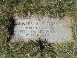

Bennie Andrew Floberg
| Birth | : | 2 Jun 1892 North Dakota, USA |
| Death | : | 21 Aug 1968 Landa, Bottineau County, North Dakota, USA |
| Burial | : | Saint John the Evangelist Catholic Church Cemetery, Forest Glen, Montgomery County, USA |
| Coordinate | : | 39.0152300, -77.0509500 |
| Description | : | World War I Name: Bennie Andrew Floberg Army #: 2,704,179 Registrant: yes, Bottineau county Birth Place: Cummings, N. Dak. Birth Date: 02 Jun 1893 Parent's Origin: of Norwegian parents Occupation: farmer Comment: inducted at Bottineau on June 23, 1918; sent to Camp Dodge, Iowa; served in Company A, 352nd Infantry, to Jan. 30, 1919; Company A, 1st Battalion, 2nd Military Police Company, to April 16, 1919; 296th Military Police Company, to May 4, 1919; 212th Military Police Company, to discharge. Grade: Private 1st Class, Feb. 18, 1919; overseas from Aug. 16, 1918, to June 26, 1919. Discharged at Camp Dodge, Iowa, on July 3, 1919, as a... Read More |
frequently asked questions (FAQ):
-
Where is Bennie Andrew Floberg's memorial?
Bennie Andrew Floberg's memorial is located at: Saint John the Evangelist Catholic Church Cemetery, Forest Glen, Montgomery County, USA.
-
When did Bennie Andrew Floberg death?
Bennie Andrew Floberg death on 21 Aug 1968 in Landa, Bottineau County, North Dakota, USA
-
Where are the coordinates of the Bennie Andrew Floberg's memorial?
Latitude: 39.0152300
Longitude: -77.0509500
Family Members:
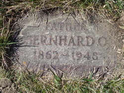
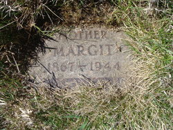
Parent
Siblings
Flowers:


Nearby Cemetories:
1. Saint John the Evangelist Catholic Church Cemetery
Forest Glen, Montgomery County, USA
Coordinate: 39.0152300, -77.0509500
2. Pilgrim Baptist Cemetery
Lyttonsville, Montgomery County, USA
Coordinate: 39.0023740, -77.0536160
3. Grace Episcopal Church Cemetery
Silver Spring, Montgomery County, USA
Coordinate: 39.0052986, -77.0381012
4. Saint Pauls United Methodist Church Memorial Garde
Kensington, Montgomery County, USA
Coordinate: 39.0268500, -77.0744600
5. Allen Chapel A. M. E. Church Cemetery
Wheaton, Montgomery County, USA
Coordinate: 39.0367500, -77.0433300
6. North Chevy Chase Christian Church Memorial Garden
Chevy Chase, Montgomery County, USA
Coordinate: 39.0019900, -77.0757800
7. Good Shepherd Episcopal Church Columbarium
Montgomery County, USA
Coordinate: 39.0322020, -77.0236240
8. Dunlop Family Cemetery
Chevy Chase, Montgomery County, USA
Coordinate: 38.9975600, -77.0805500
9. Columbia Country Club
Chevy Chase, Montgomery County, USA
Coordinate: 38.9891100, -77.0781500
10. Episcopal Church of the Ascension Columbarium
Silver Spring, Montgomery County, USA
Coordinate: 38.9914293, -77.0157511
11. Bethesda Meeting House Cemetery
Bethesda, Montgomery County, USA
Coordinate: 39.0097220, -77.0983330
12. Chevy Chase United Methodist Church Cemetery
Chevy Chase, Montgomery County, USA
Coordinate: 38.9801870, -77.0709590
13. National Museum of Health and Medicine
Washington, District of Columbia, USA
Coordinate: 38.9760170, -77.0325060
14. Lee Family Cemetery
Wheaton, Montgomery County, USA
Coordinate: 39.0516600, -77.0227800
15. Reflection Terrace Memorial
Wheaton, Montgomery County, USA
Coordinate: 39.0571500, -77.0369600
16. Cecil-Davis Cemetery
Takoma Park, Montgomery County, USA
Coordinate: 38.9890800, -76.9999100
17. Battleground National Cemetery
Washington, District of Columbia, USA
Coordinate: 38.9707298, -77.0266800
18. Chevy Chase Presbyterian Church Columbarium
Chevy Chase Heights, District of Columbia, USA
Coordinate: 38.9672380, -77.0757640
19. Hopkins Family Cemetery
White Oak, Montgomery County, USA
Coordinate: 39.0430360, -76.9937460
20. Mount Zion Cemetery
Bethesda, Montgomery County, USA
Coordinate: 39.0225182, -77.1239777
21. Saint Mark Presbyterian Memorial Garden
Rockville, Montgomery County, USA
Coordinate: 39.0317950, -77.1251710
22. Trinity Lutheran Church Columbarium
Rockville, Montgomery County, USA
Coordinate: 39.0387727, -77.1235788
23. Mount Lebanon Cemetery
Adelphi, Prince George's County, USA
Coordinate: 39.0081290, -76.9725860
24. Sitka Baptist Church Cemetery
Silver Spring, Montgomery County, USA
Coordinate: 39.0243560, -76.9704740