

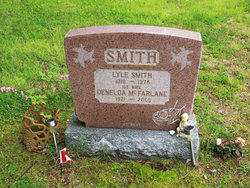
Bertha “Denelda” McFarlane Smith
| Birth | : | 9 Nov 1921 Lions Head, Bruce County, Ontario, Canada |
| Death | : | 19 Oct 2009 Lions Head, Bruce County, Ontario, Canada |
| Burial | : | Dunk's Bay Cemetery, Tobermory, Bruce County, Canada |
| Coordinate | : | 45.2489000, -81.6459000 |
| Description | : | SMITH, Denelda - of Tobermory, peacefully at Grey Bruce Health Services Lion's Head on Monday, October 19th, 2009. The former Bertha Denelda McFarlane in her 88th year. Devoted mother of Nancy Hooey (late Joe), Helen Addison (Norman), Don Smith (friend Pat Davis), David Smith (Sue), Doug Smith (Marie), Heather Munn (Randy), all of Tobermory; and special mum of Michelle Haynes, of Meaford. Cherished grandmother of 14; great-grandmother of 21; and great- great-grandmother of 2. Beloved sister of Marj Bartley, of Owen Sound; and sister-in- law of Shirley McFarlane, of Tobermory. Predeceased by... Read More |
frequently asked questions (FAQ):
-
Where is Bertha “Denelda” McFarlane Smith's memorial?
Bertha “Denelda” McFarlane Smith's memorial is located at: Dunk's Bay Cemetery, Tobermory, Bruce County, Canada.
-
When did Bertha “Denelda” McFarlane Smith death?
Bertha “Denelda” McFarlane Smith death on 19 Oct 2009 in Lions Head, Bruce County, Ontario, Canada
-
Where are the coordinates of the Bertha “Denelda” McFarlane Smith's memorial?
Latitude: 45.2489000
Longitude: -81.6459000
Family Members:
Spouse
Flowers:


Nearby Cemetories:
1. Dunk's Bay Cemetery
Tobermory, Bruce County, Canada
Coordinate: 45.2489000, -81.6459000
2. McVicar Cemetery
Saint-Edmunds Township, Bruce County, Canada
Coordinate: 45.1543480, -81.4642900
3. Stokes Bay Cemetery
Stokes Bay, Bruce County, Canada
Coordinate: 45.0052299, -81.3674927
4. Eastnor Township Cemetery
Eastnor Township, Bruce County, Canada
Coordinate: 44.9565200, -81.2648500
5. Hilly Grove Cemetery
Hilly Grove, Manitoulin District, Canada
Coordinate: 45.6789600, -81.8764700
6. Fairview Cemetery
Tehkummah, Manitoulin District, Canada
Coordinate: 45.6564280, -82.0034580
7. St. Paul's Anglican Cemetery
Manitowaning, Manitoulin District, Canada
Coordinate: 45.7447912, -81.8061589
8. Red Bay Cemetery
Red Bay, Bruce County, Canada
Coordinate: 44.8015000, -81.2827000
9. Buzwah Cemetery
Buzwah, Manitoulin District, Canada
Coordinate: 45.7660100, -81.7644500
10. Cape Croker St. Mary's First Nations Cemetery
Cape Croker, Bruce County, Canada
Coordinate: 44.9243200, -81.0198100
11. Little Port Elgin First Nations Cemetery
Little Port Elgin, Bruce County, Canada
Coordinate: 44.8880600, -81.0333400
12. Big Lake Cemetery
Manitoulin, Manitoulin District, Canada
Coordinate: 45.7457500, -82.0575900
13. Balsam Grove Cemetery
Oliphant, Bruce County, Canada
Coordinate: 44.7367000, -81.2755000
14. Lucius Albert Burial Site
Oliphant, Bruce County, Canada
Coordinate: 44.7313830, -81.2748130
15. Edgehill Cemetery
Wiarton, Bruce County, Canada
Coordinate: 44.7842700, -81.1237200
16. Providence Bay Cemetery
Providence Bay, Manitoulin District, Canada
Coordinate: 45.6728600, -82.2664600
17. Oxenden Cemetery
Oxenden, Grey County, Canada
Coordinate: 44.7620980, -81.0918510
18. Bayview Cemetery
Wiarton, Bruce County, Canada
Coordinate: 44.7354240, -81.1345901
19. Mindemoya Cemetery
Mindemoya, Manitoulin District, Canada
Coordinate: 45.7473100, -82.1928000
20. Sheguiandah Reserve Cemetery
Sheguiandah, Manitoulin District, Canada
Coordinate: 45.8809640, -81.9049780
21. Grimesthorpe Cemetery
Grimsthorpe, Manitoulin District, Canada
Coordinate: 45.7098120, -82.3246620
22. Green Bay United Church Cemetery
Manitoulin, Manitoulin District, Canada
Coordinate: 45.8603520, -82.0223110
23. M'Chigeeng Cemetery
West Bay, Manitoulin District, Canada
Coordinate: 45.8163400, -82.1601200
24. Jackson Cemetery
Amabel Township, Bruce County, Canada
Coordinate: 44.6500000, -81.1928000