
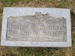
Bertha E. “Carol” Cochran Loughman
| Birth | : | 15 Sep 1934 Licking County, Ohio, USA |
| Death | : | 13 Aug 1993 Newark, Licking County, Ohio, USA |
| Burial | : | Oak Hill Cemetery, South Saint Paul, Dakota County, USA |
| Coordinate | : | 44.8922005, -93.0532990 |
| Plot | : | 96E/6 |
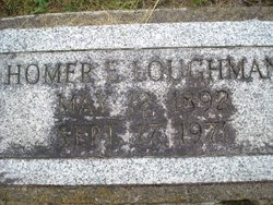
| Description | : | Loughman, Bertha E. 15 Sept 1934-13 Aug 1993 The Newark Advocate Services for Bertha E. "Carol" Loughman, 58, of 83 Mound Court will be held at 1 p.m. Tuesday in the Brucker and Kishler Funeral Home with the Rev. Robert Knox officiating. Burial will follow in Oak Hill Cemetery Mrs. Loughman died Aug 13, 1993 at Licking Memorial Hospital. She was born in Licking County on Sept. 15, 1934, to the late Homer Loughman and Mary Cochran. She was a former bartender for Newark Eagles, the Druids Club and the Blue Moon. She was a member of Newark Eagles Aerie 387 and... Read More |
frequently asked questions (FAQ):
-
Where is Bertha E. “Carol” Cochran Loughman's memorial?
Bertha E. “Carol” Cochran Loughman's memorial is located at: Oak Hill Cemetery, South Saint Paul, Dakota County, USA.
-
When did Bertha E. “Carol” Cochran Loughman death?
Bertha E. “Carol” Cochran Loughman death on 13 Aug 1993 in Newark, Licking County, Ohio, USA
-
Where are the coordinates of the Bertha E. “Carol” Cochran Loughman's memorial?
Latitude: 44.8922005
Longitude: -93.0532990
Family Members:
Parent
Spouse
Siblings

Flowers:


Nearby Cemetories:
1. Oak Hill Cemetery
South Saint Paul, Dakota County, USA
Coordinate: 44.8922005, -93.0532990
2. General Lutheran Cemetery
South Saint Paul, Dakota County, USA
Coordinate: 44.8917007, -93.0516968
3. First Presbyterian Church Memorial Garden
South Saint Paul, Dakota County, USA
Coordinate: 44.8990300, -93.0589000
4. Memorial Park and Native American Burial Grounds
South Saint Paul, Dakota County, USA
Coordinate: 44.9033910, -93.0483790
5. Kaposia Village Burial Grounds
South Saint Paul, Dakota County, USA
Coordinate: 44.8927803, -93.0347214
6. Augustana Lutheran Church Columbarium
West Saint Paul, Dakota County, USA
Coordinate: 44.9042659, -93.0797811
7. Salem United Methodist Church Cemetery
Inver Grove Heights, Dakota County, USA
Coordinate: 44.8678741, -93.0656433
8. Old Salem Evangelical Church Cemetery
Inver Grove Heights, Dakota County, USA
Coordinate: 44.8693100, -93.0752300
9. Riverview Cemetery
Saint Paul, Ramsey County, USA
Coordinate: 44.9196660, -93.0699010
10. Saint Annes Columbarium
Saint Paul, Ramsey County, USA
Coordinate: 44.8822710, -93.1008710
11. Union Cemetery
Inver Grove Heights, Dakota County, USA
Coordinate: 44.8622017, -93.0258026
12. Red Rock Cemetery
Newport, Washington County, USA
Coordinate: 44.8837900, -93.0013300
13. Old Emanuel Lutheran Church Cemetery
Inver Grove Heights, Dakota County, USA
Coordinate: 44.8478800, -93.0648600
14. Indian Mounds Park
Saint Paul, Ramsey County, USA
Coordinate: 44.9460060, -93.0547060
15. Newport Cemetery
Newport, Washington County, USA
Coordinate: 44.8560982, -92.9922028
16. Trinity Lone Oak Cemetery
Eagan, Dakota County, USA
Coordinate: 44.8503600, -93.1270750
17. Inver Hills Memorial Cemetery
Inver Grove Heights, Dakota County, USA
Coordinate: 44.8317540, -93.1028230
18. Old Peoples Home Cemetery
Cottage Grove, Washington County, USA
Coordinate: 44.8478400, -92.9750800
19. Saint John the Evangelist Episcopal Columbarium
Saint Paul, Ramsey County, USA
Coordinate: 44.9428200, -93.1236700
20. Resurrection Cemetery
Mendota Heights, Dakota County, USA
Coordinate: 44.8767014, -93.1513977
21. Saint Thomas Aquinas Cemetery
Saint Paul Park, Washington County, USA
Coordinate: 44.8425000, -92.9806600
22. House of Hope Presbyterian Church Memorial Garden
Saint Paul, Ramsey County, USA
Coordinate: 44.9418400, -93.1329500
23. Woodbury Methodist Cemetery
Woodbury, Washington County, USA
Coordinate: 44.9187400, -92.9533970
24. Church of Saint Peter Historic Cemetery
Mendota, Dakota County, USA
Coordinate: 44.8839417, -93.1671906