
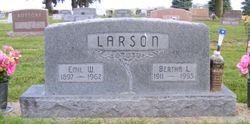
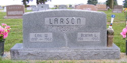
Bertha L. Eckert Davis
| Birth | : | 4 Jul 1911 Redington, Morrill County, Nebraska, USA |
| Death | : | 19 Nov 1995 Aurora, Hamilton County, Nebraska, USA |
| Burial | : | Mohall Cemetery, Cut Bank Township, Bottineau County, USA |
| Coordinate | : | 48.7627983, -101.4850006 |
| Description | : | Bertha Davis, the daughter of Jacob and Bessie (Broughton) Eckert was born at Redington, Nebraska on July 4, 1911, and died at Aurora, Nebraska on November 19, 1995 at the age of 84 years, 4 months, and 15 days. She grew up and attended school at Dalton, Nebraska. On September 14, 1927, she was united in marriage to Emil Larson at Sidney, Nebraska. They farmed near Aurora, where they raised their family. Emil died March 17, 1962. On October 25, 1970, she was united in marriage to Donald Davis at Aurora. They farmed near Giltner until 1973... Read More |
frequently asked questions (FAQ):
-
Where is Bertha L. Eckert Davis's memorial?
Bertha L. Eckert Davis's memorial is located at: Mohall Cemetery, Cut Bank Township, Bottineau County, USA.
-
When did Bertha L. Eckert Davis death?
Bertha L. Eckert Davis death on 19 Nov 1995 in Aurora, Hamilton County, Nebraska, USA
-
Where are the coordinates of the Bertha L. Eckert Davis's memorial?
Latitude: 48.7627983
Longitude: -101.4850006
Family Members:
Spouse
Flowers:


Nearby Cemetories:
1. Mohall Cemetery
Cut Bank Township, Bottineau County, USA
Coordinate: 48.7627983, -101.4850006
2. Brotherhood Cemetery
Bottineau County, USA
Coordinate: 48.7780991, -101.4736023
3. Renville Cemetery
Renville, Bottineau County, USA
Coordinate: 48.7485900, -101.3220700
4. Loraine Cemetery
Loraine, Renville County, USA
Coordinate: 48.8672000, -101.5627000
5. Haas Cemetery
Antler, Bottineau County, USA
Coordinate: 48.8931007, -101.3977966
6. Saint Johns Cemetery
Lansford, Bottineau County, USA
Coordinate: 48.6314011, -101.3961029
7. Saint Johns United Lutheran Cemetery
Mohall, Renville County, USA
Coordinate: 48.7928429, -101.7149429
8. Lansford Cemetery
Lansford, Bottineau County, USA
Coordinate: 48.6189003, -101.3867035
9. Bethel Lutheran Brethren Cemetery
Antler, Bottineau County, USA
Coordinate: 48.8720245, -101.3008423
10. Grano Cemetery
Grano, Renville County, USA
Coordinate: 48.6136017, -101.6038971
11. Eden Valley Cemetery
Sherwood, Renville County, USA
Coordinate: 48.9366989, -101.5625000
12. Hamerly Lutheran Cemetery
Mohall, Renville County, USA
Coordinate: 48.8654700, -101.7270000
13. McKinney Cemetery
Tolley, Renville County, USA
Coordinate: 48.7594261, -101.7830963
14. Union Cemetery
Sherwood, Renville County, USA
Coordinate: 48.9505997, -101.6508026
15. Saint John Cemetery
Mohall, Renville County, USA
Coordinate: 48.9184380, -101.7382889
16. Graceland Cemetery
Maxbass, Bottineau County, USA
Coordinate: 48.7344017, -101.1363983
17. Saint Charles Cemetery
Tolley, Renville County, USA
Coordinate: 48.7340012, -101.8345108
18. Trinity Cemetery
Tolley, Renville County, USA
Coordinate: 48.7261009, -101.8341980
19. Shook Cemetery
Renville County, USA
Coordinate: 48.5419273, -101.3651505
20. Gethsemane Cemetery
Carpio, Ward County, USA
Coordinate: 48.5747261, -101.7124481
21. Weeks Cemetery
Westhope, Bottineau County, USA
Coordinate: 48.8365800, -101.1251700
22. Saint Marys Cemetery
Antler, Bottineau County, USA
Coordinate: 48.9805753, -101.2897461
23. Antler Cemetery
Antler, Bottineau County, USA
Coordinate: 48.9808006, -101.2878036
24. Antler Pioneer Cemetery
Antler, Bottineau County, USA
Coordinate: 48.9994090, -101.2626620