
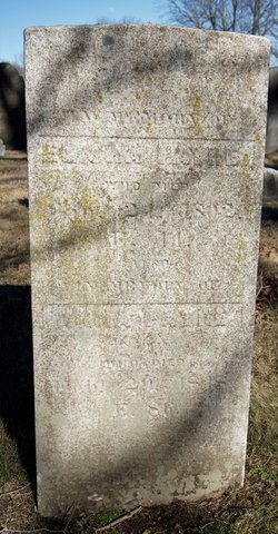
| Birth | : | 28 Dec 1787 Canterbury, Windham County, Connecticut, USA |
| Death | : | 26 May 1879 Lisbon, New London County, Connecticut, USA |
| Burial | : | Liberty Cemetery, Gould, Harmon County, USA |
| Coordinate | : | 34.6232986, -99.7525024 |
| Description | : | widow of Charles Perkins age 91 yrs. 5 mos. |
frequently asked questions (FAQ):
-
Where is Betsey “Elizabeth” Payne Perkins's memorial?
Betsey “Elizabeth” Payne Perkins's memorial is located at: Liberty Cemetery, Gould, Harmon County, USA.
-
When did Betsey “Elizabeth” Payne Perkins death?
Betsey “Elizabeth” Payne Perkins death on 26 May 1879 in Lisbon, New London County, Connecticut, USA
-
Where are the coordinates of the Betsey “Elizabeth” Payne Perkins's memorial?
Latitude: 34.6232986
Longitude: -99.7525024
Family Members:
Parent

Spouse

Siblings

Children
Flowers:


Nearby Cemetories:
1. Liberty Cemetery
Gould, Harmon County, USA
Coordinate: 34.6232986, -99.7525024
2. Gould Cemetery
Gould, Harmon County, USA
Coordinate: 34.6808014, -99.7699966
3. Louis Cemetery
Louis, Harmon County, USA
Coordinate: 34.5607986, -99.8281021
4. Pleasant Hill Cemetery
Gould, Harmon County, USA
Coordinate: 34.5217018, -99.7347031
5. Cottonwood Cemetery
Duke, Jackson County, USA
Coordinate: 34.6377983, -99.6203003
6. Dryden Cemetery
Hollis, Harmon County, USA
Coordinate: 34.7401100, -99.8225000
7. Russell Cemetery
Russell, Greer County, USA
Coordinate: 34.7550011, -99.6671982
8. Fairmount Cemetery
Hollis, Harmon County, USA
Coordinate: 34.6711006, -99.9281006
9. Rock Cemetery
Duke, Jackson County, USA
Coordinate: 34.7089005, -99.5811005
10. Duke Cemetery
Duke, Jackson County, USA
Coordinate: 34.6514015, -99.5535965
11. Prairie Hill Cemetery
Jackson County, USA
Coordinate: 34.5944977, -99.5449753
12. Halsmith Cemetery
Harmon County, USA
Coordinate: 34.6077995, -99.9642029
13. Railroad Cemetery
Eldorado, Jackson County, USA
Coordinate: 34.4492200, -99.6913500
14. Eldorado Cemetery
Eldorado, Jackson County, USA
Coordinate: 34.4589005, -99.6557999
15. Guffin Cemetery
Duke, Jackson County, USA
Coordinate: 34.6466780, -99.5282150
16. McKnight Cemetery
Hollis, Harmon County, USA
Coordinate: 34.7593994, -99.9113998
17. Antioch Cemetery
Eldorado, Jackson County, USA
Coordinate: 34.4356003, -99.7067032
18. Westview Cemetery
Hollis, Harmon County, USA
Coordinate: 34.6825100, -99.9818900
19. Tea Cross Cemetery
Harmon County, USA
Coordinate: 34.7980995, -99.8681030
20. Wildcat Cemetery
Greer County, USA
Coordinate: 34.8260994, -99.7189026
21. Lanford Cemetery
Greer County, USA
Coordinate: 34.8264885, -99.7136307
22. Johnston Cemetery
Hardeman County, USA
Coordinate: 34.4481010, -99.8936005
23. Bitter Creek Cemetery
Harmon County, USA
Coordinate: 34.7477989, -99.9811020
24. Kreis Family Cemetery
Loco, Childress County, USA
Coordinate: 34.5994930, -100.0313610