


Betty Ann Robinson Rapp Tuttle
| Birth | : | 1 Jul 1923 Fort Dodge, Webster County, Iowa, USA |
| Death | : | 11 Jul 1984 Fort Dodge, Webster County, Iowa, USA |
| Burial | : | Paton Cemetery, Paton, Greene County, USA |
| Coordinate | : | 42.1624985, -94.2433014 |
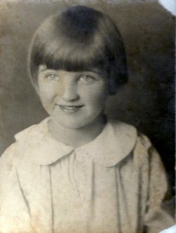
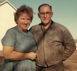
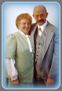
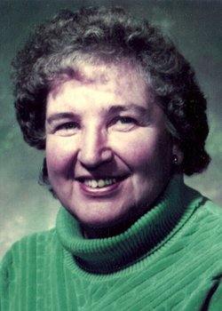
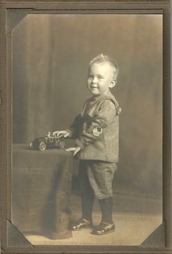
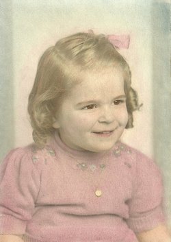
| Description | : | Betty Ann Robinson was born Sunday, July 1, 1923 in Fort Dodge, Iowa. She was the daughter of Frank Earnest Robinson and Beulah Louise (Crouse) Robinson. Six years later, her sister Lillie Mae Robinson was born. The family moved to Topeka, Kansas. While living in Topeka, her father died suddenly at age 30 of a ruptured appendix, leaving his wife and two young daughters. Betty's mother took in laundry and sold pies, later working for Singer Sewing Machine company, to provide for her family. Betty was also cared for by her maternal grandparents, Charles and Minnie (Porter)... Read More |
frequently asked questions (FAQ):
-
Where is Betty Ann Robinson Rapp Tuttle's memorial?
Betty Ann Robinson Rapp Tuttle's memorial is located at: Paton Cemetery, Paton, Greene County, USA.
-
When did Betty Ann Robinson Rapp Tuttle death?
Betty Ann Robinson Rapp Tuttle death on 11 Jul 1984 in Fort Dodge, Webster County, Iowa, USA
-
Where are the coordinates of the Betty Ann Robinson Rapp Tuttle's memorial?
Latitude: 42.1624985
Longitude: -94.2433014
Family Members:
Flowers:


Nearby Cemetories:
1. Paton Cemetery
Paton, Greene County, USA
Coordinate: 42.1624985, -94.2433014
2. Dawson Cemetery
Paton, Greene County, USA
Coordinate: 42.1655998, -94.3283005
3. Renner Cemetery
Boone County, USA
Coordinate: 42.1380420, -94.1256570
4. Lost Grove Cemetery
Harcourt, Webster County, USA
Coordinate: 42.2583008, -94.2331009
5. Swedish Lutheran Church Cemetery
Dayton, Webster County, USA
Coordinate: 42.2175000, -94.1065000
6. Lawn Cemetery
Boone County, USA
Coordinate: 42.1771011, -94.0867996
7. Union Cemetery
Boxholm, Boone County, USA
Coordinate: 42.1369019, -94.0852966
8. Grand Ridge Cemetery
Beaver, Boone County, USA
Coordinate: 42.0786018, -94.1157990
9. Gowrie Township Cemetery
Gowrie, Webster County, USA
Coordinate: 42.2813988, -94.3043976
10. Mount Calvary Cemetery
Grand Junction, Greene County, USA
Coordinate: 42.0266000, -94.2325000
11. Beaver Cemetery
Beaver, Boone County, USA
Coordinate: 42.0462000, -94.1446000
12. Junction Township Cemetery
Grand Junction, Greene County, USA
Coordinate: 42.0236015, -94.2593994
13. Maple Grove Cemetery
Boxholm, Boone County, USA
Coordinate: 42.0793690, -94.0859890
14. Maas Cemetery
Boone County, USA
Coordinate: 42.0908012, -94.0618973
15. Pilot Mound Cemetery
Pilot Mound, Boone County, USA
Coordinate: 42.1636200, -94.0282600
16. Christ the King Catholic Cemetery
Dayton, Webster County, USA
Coordinate: 42.2601929, -94.0727539
17. Dayton Cemetery
Dayton, Webster County, USA
Coordinate: 42.2675000, -94.0755000
18. Highland Township Cemetery
Churdan, Greene County, USA
Coordinate: 42.1518310, -94.4699120
19. Saint Joseph Cemetery
Jefferson, Greene County, USA
Coordinate: 42.0289001, -94.3818970
20. Reading Cemetery
Farnhamville, Calhoun County, USA
Coordinate: 42.2593994, -94.4325027
21. Jefferson Cemetery
Jefferson, Greene County, USA
Coordinate: 42.0133018, -94.3591995
22. Runyan Cemetery
Pilot Mound, Boone County, USA
Coordinate: 42.1749992, -94.0015030
23. Our Saviour Cemetery
Callender, Webster County, USA
Coordinate: 42.3396988, -94.3153000
24. Linn Cemetery
Pilot Mound, Boone County, USA
Coordinate: 42.2045330, -93.9970230