
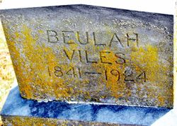
Beulah Hurst Viles
| Birth | : | 11 May 1841 Indiana, USA |
| Death | : | 12 May 1924 Maryville, Nodaway County, Missouri, USA |
| Burial | : | St. Nicholas' Churchyard, Whiston, Metropolitan Borough of Knowsley, England |
| Coordinate | : | 53.4069736, -2.8028920 |
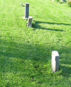
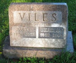
| Plot | : | Sec 5, Row 4, north, next to Charles and Julia Viles. |
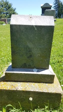
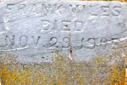
| Description | : | Wife of Joseph Richard Viles, informant is Charles Viles daughter of Henry Hurst and Mary Hockett or Stockett, The last name of Joseph Richard Viles was origionaly Voiles, he is the son of Joseph Voiles and and Martha "Patsy" Martin who were married 08 Dec 1814 Mercer County, Kentucky |
frequently asked questions (FAQ):
-
Where is Beulah Hurst Viles's memorial?
Beulah Hurst Viles's memorial is located at: St. Nicholas' Churchyard, Whiston, Metropolitan Borough of Knowsley, England.
-
When did Beulah Hurst Viles death?
Beulah Hurst Viles death on 12 May 1924 in Maryville, Nodaway County, Missouri, USA
-
Where are the coordinates of the Beulah Hurst Viles's memorial?
Latitude: 53.4069736
Longitude: -2.8028920
Family Members:
Spouse
Children

Flowers:


Nearby Cemetories:
1. St. Nicholas' Churchyard
Whiston, Metropolitan Borough of Knowsley, England
Coordinate: 53.4069736, -2.8028920
2. Knowsley Cemetery
Knowsley, Metropolitan Borough of Knowsley, England
Coordinate: 53.4083240, -2.7847870
3. St. Agnes Roman Catholic
Huyton with Roby, Metropolitan Borough of Knowsley, England
Coordinate: 53.4090600, -2.8320100
4. Prescot Cemetery
Prescot, Metropolitan Borough of Knowsley, England
Coordinate: 53.4266620, -2.8081590
5. St. Mary the Virgin Churchyard
Prescot, Metropolitan Borough of Knowsley, England
Coordinate: 53.4284600, -2.8067000
6. St. Michael Churchyard
Huyton with Roby, Metropolitan Borough of Knowsley, England
Coordinate: 53.4139560, -2.8396720
7. St Michael Churchyard Extension
Huyton with Roby, Metropolitan Borough of Knowsley, England
Coordinate: 53.4143310, -2.8418050
8. St Ann’s Graveyard
Rainhill, Metropolitan Borough of St Helens, England
Coordinate: 53.4157487, -2.7638276
9. St Bartholomew's Churchyard
Rainhill, Metropolitan Borough of St Helens, England
Coordinate: 53.4076231, -2.7513287
10. St. Bartholomew's Churchyard
Huyton with Roby, Metropolitan Borough of Knowsley, England
Coordinate: 53.4120023, -2.8556125
11. St. Nicholas Churchyard
Halewood, Metropolitan Borough of Knowsley, England
Coordinate: 53.3694400, -2.8284900
12. All Saints Churchyard
Childwall, Metropolitan Borough of Liverpool, England
Coordinate: 53.3952880, -2.8816030
13. Christ Church Churchyard
Eccleston, Metropolitan Borough of St Helens, England
Coordinate: 53.4542560, -2.7778900
14. Widnes Cemetery
Widnes, Halton Unitary Authority, England
Coordinate: 53.3803470, -2.7326050
15. Yew Tree Roman Catholic Cemetery
West Derby, Metropolitan Borough of Liverpool, England
Coordinate: 53.4285700, -2.8790700
16. St. Peter's Churchyard
Woolton, Metropolitan Borough of Liverpool, England
Coordinate: 53.3759310, -2.8693390
17. St. Luke's Churchyard
Farnworth, Halton Unitary Authority, England
Coordinate: 53.3843810, -2.7271840
18. St. Mary's Churchyard
Woolton, Metropolitan Borough of Liverpool, England
Coordinate: 53.3750550, -2.8703760
19. St Nicholas Churchyard
St Helens, Metropolitan Borough of St Helens, England
Coordinate: 53.4284660, -2.7213830
20. St. John the Evangelist Churchyard
Knotty Ash, Metropolitan Borough of Liverpool, England
Coordinate: 53.4160757, -2.8913708
21. Broadgreen Jewish Cemetery
Liverpool, Metropolitan Borough of Liverpool, England
Coordinate: 53.4101320, -2.8977320
22. St. Mary's Churchyard
Knowsley, Metropolitan Borough of Knowsley, England
Coordinate: 53.4561960, -2.8528580
23. Calderstones Park
Liverpool, Metropolitan Borough of Liverpool, England
Coordinate: 53.3817419, -2.8956218
24. Friends Meeting House, Hardshaw, St Helens
St Helens, Metropolitan Borough of St Helens, England
Coordinate: 53.4518340, -2.7320414