
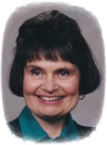
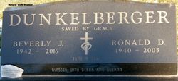
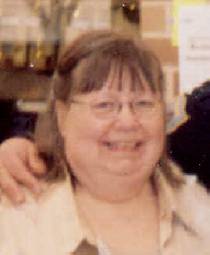
Beverly Jean Holler Dunkelberger
| Birth | : | 2 Dec 1942 Correctionville, Woodbury County, Iowa, USA |
| Death | : | 25 Oct 2016 Spencer, Clay County, Iowa, USA |
| Burial | : | Riverside Cemetery, Spencer, Clay County, USA |
| Coordinate | : | 43.1441994, -95.1671982 |
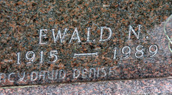
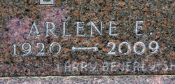
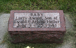
| Description | : | Beverly Jean Dunkelberger, the daughter of Ewald "Nick" and Arlene (Noble) Holler, was born December 2, 1942 in Correctionville, IA. Her childhood years were spent in the communities of Correctionville, Washta and Alta, Iowa until moving to a farm near Linn Grove in 1956, where she received her education. She attended college in Mankato, where she met the love of her life, Ron of Jeffers, MN Ron & Bev were married on June 9, 1962, at Riverside Presbyterian Church in Linn Grove. Together, they were the parents of two daughters: Deb and DeeAnn. They lived in Mankato, Forest City and then... Read More |
frequently asked questions (FAQ):
-
Where is Beverly Jean Holler Dunkelberger's memorial?
Beverly Jean Holler Dunkelberger's memorial is located at: Riverside Cemetery, Spencer, Clay County, USA.
-
When did Beverly Jean Holler Dunkelberger death?
Beverly Jean Holler Dunkelberger death on 25 Oct 2016 in Spencer, Clay County, Iowa, USA
-
Where are the coordinates of the Beverly Jean Holler Dunkelberger's memorial?
Latitude: 43.1441994
Longitude: -95.1671982
Family Members:
Parent
Spouse

Siblings
Flowers:


Nearby Cemetories:
1. Riverside Cemetery
Spencer, Clay County, USA
Coordinate: 43.1441994, -95.1671982
2. Dewey Readmore Books Memorial
Spencer, Clay County, USA
Coordinate: 43.1403999, -95.1443024
3. North Lawn Cemetery
Spencer, Clay County, USA
Coordinate: 43.1600000, -95.1470000
4. Evergreen Cemetery
Clay County, USA
Coordinate: 43.2052994, -95.2086029
5. Fairview Cemetery
Clay County, USA
Coordinate: 43.1899986, -95.0800018
6. Swedish Lutheran Cemetery
Royal, Clay County, USA
Coordinate: 43.0683000, -95.2350000
7. Dickens Cemetery
Dickens, Clay County, USA
Coordinate: 43.1280000, -95.0155000
8. Rosehill Cemetery
Clay County, USA
Coordinate: 43.0368996, -95.0919037
9. Lone Tree Cemetery
Everly, Clay County, USA
Coordinate: 43.1411018, -95.3347015
10. Little Sioux Lutheran Cemetery
Milford, Dickinson County, USA
Coordinate: 43.2702065, -95.2109528
11. First Reformed Cemetery
Clay County, USA
Coordinate: 43.2399500, -95.2889000
12. Lincoln Cemetery
Rossie, Clay County, USA
Coordinate: 43.0111008, -95.2313995
13. Willow Creek Cemetery
Royal, Clay County, USA
Coordinate: 43.0214005, -95.2885971
14. Liberty Cemetery
Greenville, Clay County, USA
Coordinate: 42.9897003, -95.1417007
15. Clay Center Cemetery
Royal, Clay County, USA
Coordinate: 43.0410995, -95.3272018
16. Milford Cemetery
Milford, Dickinson County, USA
Coordinate: 43.3092003, -95.1481018
17. TriMello Cemetery
Royal, Clay County, USA
Coordinate: 43.0682983, -95.3728027
18. Logan Township Cemetery
Clay County, USA
Coordinate: 43.0489006, -94.9747009
19. Zion Methodist Cemetery
Clay County, USA
Coordinate: 42.9808006, -95.2497025
20. Calvary Cemetery
Milford, Dickinson County, USA
Coordinate: 43.3213997, -95.1688995
21. Fanny Fern Cemetery
Clay County, USA
Coordinate: 42.9530983, -95.1607971
22. Crown Hill Cemetery
Ruthven, Palo Alto County, USA
Coordinate: 43.1328011, -94.8878021
23. Calvary Cemetery
Ruthven, Palo Alto County, USA
Coordinate: 43.1314011, -94.8869019
24. Westport Cemetery
Dickinson County, USA
Coordinate: 43.3130989, -95.3289032