

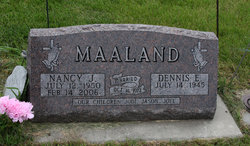
Nancy Joelle Holler Maaland
| Birth | : | 12 Jul 1950 Cherokee, Cherokee County, Iowa, USA |
| Death | : | 14 Feb 2006 Sutherland, O'Brien County, Iowa, USA |
| Burial | : | Barnes Township Cemetery, Linn Grove, Buena Vista County, USA |
| Coordinate | : | 42.8880997, -95.2397003 |
| Inscription | : | Married Oct. 14, 1972 Our children: Jodi, Jason, Joel |
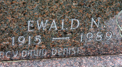
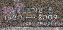
| Description | : | Nancy Joelle Maaland, the daughter of Ewald "Nick" and Arlene (Noble) Holler, was born on July 12, 1950, in Cherokee, Iowa. She spent her childhood years in the Linn Grove area, where she received her early education and graduated from Sioux Valley High School in 1968. On October 14, 1972, Nancy married Dennis Maaland in Jackson, MN. Following their marriage, they made their home in Sutherland, IA, where she was a homemaker and raised her family. In 1993, Nancy worked at the Primghar Dinner Date Site for Northwest Iowa Aging Association and in 1997, she became the Nutrition Director at... Read More |
frequently asked questions (FAQ):
-
Where is Nancy Joelle Holler Maaland's memorial?
Nancy Joelle Holler Maaland's memorial is located at: Barnes Township Cemetery, Linn Grove, Buena Vista County, USA.
-
When did Nancy Joelle Holler Maaland death?
Nancy Joelle Holler Maaland death on 14 Feb 2006 in Sutherland, O'Brien County, Iowa, USA
-
Where are the coordinates of the Nancy Joelle Holler Maaland's memorial?
Latitude: 42.8880997
Longitude: -95.2397003
Family Members:
Parent
Siblings

Flowers:


Nearby Cemetories:
1. Barnes Township Cemetery
Linn Grove, Buena Vista County, USA
Coordinate: 42.8880997, -95.2397003
2. Douglas Township Cemetery
Clay County, USA
Coordinate: 42.9255981, -95.2450027
3. Little Sioux Valley Cemetery
Rembrandt, Buena Vista County, USA
Coordinate: 42.8375015, -95.2074966
4. Lone Tree Cemetery
Sioux Rapids, Buena Vista County, USA
Coordinate: 42.8819008, -95.1492004
5. Saint Josephs Cemetery
Sioux Rapids, Buena Vista County, USA
Coordinate: 42.8883018, -95.1324997
6. Oakland Cemetery
Peterson, Clay County, USA
Coordinate: 42.9281006, -95.3432999
7. Fanny Fern Cemetery
Clay County, USA
Coordinate: 42.9530983, -95.1607971
8. Zion Methodist Cemetery
Clay County, USA
Coordinate: 42.9808006, -95.2497025
9. Saint Johannes Cemetery
Brooke Township, Buena Vista County, USA
Coordinate: 42.8662758, -95.3669968
10. Plainview Cemetery
Alta, Buena Vista County, USA
Coordinate: 42.8087100, -95.3280200
11. Burr Oak Cemetery
Herdland Township, Clay County, USA
Coordinate: 42.9235992, -95.0907974
12. Lincoln Cemetery
Rossie, Clay County, USA
Coordinate: 43.0111008, -95.2313995
13. Liberty Cemetery
Greenville, Clay County, USA
Coordinate: 42.9897003, -95.1417007
14. Immanuel Lutheran Church Cemetery
Aurelia, Cherokee County, USA
Coordinate: 42.8165000, -95.3885000
15. Elk Cemetery
Elk Township, Buena Vista County, USA
Coordinate: 42.7641983, -95.3094025
16. Willow Creek Cemetery
Royal, Clay County, USA
Coordinate: 43.0214005, -95.2885971
17. Hannibal H Waterman Cemetery
O'Brien County, USA
Coordinate: 42.9375530, -95.4170760
18. Osborn Cemetery
Webb, Clay County, USA
Coordinate: 42.9346918, -95.0608244
19. Haight Family Farm Cemetery
Aurelia, Cherokee County, USA
Coordinate: 42.7778400, -95.3781060
20. Fred Feldman Grave
Waterman Township, O'Brien County, USA
Coordinate: 42.9178590, -95.4433340
21. Clay Center Cemetery
Royal, Clay County, USA
Coordinate: 43.0410995, -95.3272018
22. Lincoln Township Cemetery
Buena Vista County, USA
Coordinate: 42.7413000, -95.1282000
23. Swedish Lutheran Cemetery
Royal, Clay County, USA
Coordinate: 43.0683000, -95.2350000
24. Poland Township Cemetery
Marathon, Buena Vista County, USA
Coordinate: 42.8610992, -94.9916992