


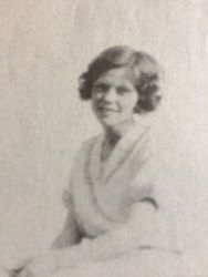
Billie Nell Westmoreland Hiatt
| Birth | : | 26 May 1933 Mount Airy, Surry County, North Carolina, USA |
| Death | : | 19 Jun 2020 Dobson, Surry County, North Carolina, USA |
| Burial | : | Mount Bethel Moravian Graveyard, Cana, Carroll County, USA |
| Coordinate | : | 36.6053120, -80.6272700 |
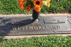
| Description | : | Mrs. Billie Nell Westmoreland Hiatt, 87, of Mount Airy, passed away Friday afternoon, June 19, 2020, at the Joan and Howard Woltz Hospice Home in Dobson. Mrs. Hiatt was born May 26, 1933, in Surry County, the oldest of three children born to the late Carl and Mary Louise Chappell Westmoreland. Billie Nell worked in banking for 67 years, beginning her longtime career at Workmen’s Federal Savings and Loan and later at Surrey Bank and Trust until March, 2020. She was a charter member of the Granite City Chapter of the American Business Women’s Association. Mrs.... Read More |
frequently asked questions (FAQ):
-
Where is Billie Nell Westmoreland Hiatt's memorial?
Billie Nell Westmoreland Hiatt's memorial is located at: Mount Bethel Moravian Graveyard, Cana, Carroll County, USA.
-
When did Billie Nell Westmoreland Hiatt death?
Billie Nell Westmoreland Hiatt death on 19 Jun 2020 in Dobson, Surry County, North Carolina, USA
-
Where are the coordinates of the Billie Nell Westmoreland Hiatt's memorial?
Latitude: 36.6053120
Longitude: -80.6272700
Family Members:
Parent
Spouse
Flowers:


Nearby Cemetories:
1. Mount Bethel Moravian Graveyard
Cana, Carroll County, USA
Coordinate: 36.6053120, -80.6272700
2. Allen Cemetery
Cana, Carroll County, USA
Coordinate: 36.6155280, -80.6192210
3. Harrold Cemetery
Carroll County, USA
Coordinate: 36.6199300, -80.6219970
4. Flat Ridge Baptist Church Cemetery
Cana, Carroll County, USA
Coordinate: 36.5867470, -80.6298910
5. Westmoreland Cemetery
Cana, Carroll County, USA
Coordinate: 36.5850100, -80.6461990
6. Montgomery Family Cemetery
Ararat, Patrick County, USA
Coordinate: 36.6239760, -80.5977920
7. Gwynn Cemetery
Ararat, Patrick County, USA
Coordinate: 36.6298835, -80.6046284
8. Portis Cemetery
Ararat, Patrick County, USA
Coordinate: 36.6132460, -80.5890090
9. Gunnell Family Cemetery
Ararat, Patrick County, USA
Coordinate: 36.6034190, -80.5852510
10. Inscore Cemetery
Ararat, Patrick County, USA
Coordinate: 36.5988000, -80.5838000
11. Noonkester Family Cemetery
Ararat, Patrick County, USA
Coordinate: 36.6019990, -80.5830940
12. Speas Family Cemetery
Cana, Carroll County, USA
Coordinate: 36.5724564, -80.6447983
13. Gunnell - Bowman - Fleming Cemetery
Ararat, Patrick County, USA
Coordinate: 36.5898540, -80.5866110
14. Willis Gap Baptist Church Cemetery
Ararat, Patrick County, USA
Coordinate: 36.5925140, -80.5850250
15. Thomas Cemetery
Fancy Gap, Carroll County, USA
Coordinate: 36.6312940, -80.6592180
16. Mountain View Primitive Baptist Church Cemetery
Ararat, Patrick County, USA
Coordinate: 36.6127720, -80.5827530
17. Harrold Family Cemetery
Ararat, Patrick County, USA
Coordinate: 36.6197740, -80.5845790
18. Bear Trail Baptist Church Cemetery
Cana, Carroll County, USA
Coordinate: 36.6263910, -80.6655010
19. A.L. Jones Family Cemetery
Cana, Carroll County, USA
Coordinate: 36.5754410, -80.6561640
20. Oak Grove Baptist Church Cemetery
Cana, Carroll County, USA
Coordinate: 36.6432470, -80.6280060
21. Cana Baptist Church Cemetery
Cana, Carroll County, USA
Coordinate: 36.5920764, -80.6717347
22. Epworth United Methodist Church Cemetery
Cana, Carroll County, USA
Coordinate: 36.5736110, -80.6536110
23. Crooked Oak Moravian Church Cemetery
Cana, Carroll County, USA
Coordinate: 36.6385210, -80.6507840
24. Primitive Baptist Church Of Jesus Christ Cemetery
Cana, Carroll County, USA
Coordinate: 36.5917320, -80.6737210