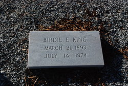
Birdie Elrod King
| Birth | : | 21 Mar 1893 South Carolina, USA |
| Death | : | 14 Jul 1974 Anderson, Anderson County, South Carolina, USA |
| Burial | : | Shelby-Oakland Cemetery, Shelby, Richland County, USA |
| Coordinate | : | 40.8718987, -82.6652985 |
frequently asked questions (FAQ):
-
Where is Birdie Elrod King's memorial?
Birdie Elrod King's memorial is located at: Shelby-Oakland Cemetery, Shelby, Richland County, USA.
-
When did Birdie Elrod King death?
Birdie Elrod King death on 14 Jul 1974 in Anderson, Anderson County, South Carolina, USA
-
Where are the coordinates of the Birdie Elrod King's memorial?
Latitude: 40.8718987
Longitude: -82.6652985
Family Members:
Spouse
Children
Flowers:
Nearby Cemetories:
1. Shelby-Oakland Cemetery
Shelby, Richland County, USA
Coordinate: 40.8718987, -82.6652985
2. Most Pure Heart of Mary Catholic Cemetery
Shelby, Richland County, USA
Coordinate: 40.8702698, -82.6650772
3. Coltman Cemetery
Shelby, Richland County, USA
Coordinate: 40.8572617, -82.6578293
4. London Cemetery
Shelby, Richland County, USA
Coordinate: 40.8860207, -82.6218033
5. German Reform Cemetery
Shelby, Richland County, USA
Coordinate: 40.8349180, -82.6774410
6. Myers Cemetery
Shelby, Richland County, USA
Coordinate: 40.8796997, -82.7164001
7. Mount Bethel Cemetery
Jackson Township, Richland County, USA
Coordinate: 40.8427811, -82.6058273
8. Sacred Heart Cemetery
Shelby, Richland County, USA
Coordinate: 40.8384552, -82.7230606
9. Missionaries of the Sacred Heart Cemetery
Shelby, Richland County, USA
Coordinate: 40.8328200, -82.6033870
10. Hazel Brush Cemetery
Shelby, Richland County, USA
Coordinate: 40.9305992, -82.6177979
11. Mount Pleasant Cemetery
Plymouth Township, Richland County, USA
Coordinate: 40.9446340, -82.6639080
12. Springmill Mennonite Church Cemetery
London, Richland County, USA
Coordinate: 40.9448920, -82.6426800
13. Dickson Cemetery
Crawford County, USA
Coordinate: 40.8863983, -82.7641983
14. Hanna Cemetery
Tiro, Crawford County, USA
Coordinate: 40.9317230, -82.7435125
15. Ganges Cemetery
Ganges, Richland County, USA
Coordinate: 40.9049034, -82.5616302
16. Liberty Cemetery
North Robinson, Crawford County, USA
Coordinate: 40.8577995, -82.7821594
17. Spring Mill Cemetery
Mansfield, Richland County, USA
Coordinate: 40.8052060, -82.5836890
18. Boyce Cemetery
Taylortown, Richland County, USA
Coordinate: 40.8578170, -82.5437590
19. Saint Joseph Cemetery
Sandusky Township, Richland County, USA
Coordinate: 40.7871600, -82.7215628
20. Church of the Brethren Cemetery
Amoy, Richland County, USA
Coordinate: 40.8495026, -82.5425034
21. Oakland Cemetery
Auburn Township, Crawford County, USA
Coordinate: 40.9104802, -82.7819932
22. Greenlawn Cemetery
East Crestline, Richland County, USA
Coordinate: 40.7850571, -82.7226782
23. Opdyke Cemetery
Plymouth, Richland County, USA
Coordinate: 40.9695549, -82.6601791
24. Bly Farm Cemetery
Mansfield, Richland County, USA
Coordinate: 40.8976560, -82.5383750


