
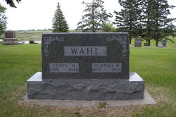
| Birth | : | 18 Apr 1930 Bristol, Day County, South Dakota, USA |
| Death | : | 12 Oct 2010 Rapid City, Pennington County, South Dakota, USA |
| Burial | : | Black Hills National Cemetery, Sturgis, Meade County, USA |
| Coordinate | : | 44.3689003, -103.4753036 |
| Plot | : | J_739 |
| Description | : | Bonnie (Wahl) Baumann, 80, of Rapid City and formerly of Lead, died Tuesday, October 12, 2010 at Golden Living Center Bella Vista in Rapid City. Memorial Services will be at 1:00 P.M. on Thursday, October 14, 2010 at First Presbyterian Church in Lead with Pastor Steve Agan officiating. Inurnment will take place at 10:00 A.M. on Friday, October 15, 2010 at Black Hills National Cemetery near Sturgis. In lieu of flowers a memorial has been established. Bonnie was born on April 18, 1930 to Edwin and Florence (Johnson) Wahl in Bristol, SD. She graduated as the class Salutatorian... Read More |
frequently asked questions (FAQ):
-
Where is Bonnie Esther Wahl Baumann's memorial?
Bonnie Esther Wahl Baumann's memorial is located at: Black Hills National Cemetery, Sturgis, Meade County, USA.
-
When did Bonnie Esther Wahl Baumann death?
Bonnie Esther Wahl Baumann death on 12 Oct 2010 in Rapid City, Pennington County, South Dakota, USA
-
Where are the coordinates of the Bonnie Esther Wahl Baumann's memorial?
Latitude: 44.3689003
Longitude: -103.4753036
Family Members:
Parent

Spouse

Siblings
Flowers:


Nearby Cemetories:
1. Black Hills National Cemetery
Sturgis, Meade County, USA
Coordinate: 44.3689003, -103.4753036
2. Curley Grimes Memorial Cemetery
Sturgis, Meade County, USA
Coordinate: 44.3764500, -103.4691300
3. Fort Meade National Cemetery
Sturgis, Meade County, USA
Coordinate: 44.4021988, -103.4757996
4. Bear Butte Cemetery
Sturgis, Meade County, USA
Coordinate: 44.4111595, -103.4947968
5. Saint Aloysius Cemetery
Sturgis, Meade County, USA
Coordinate: 44.4141340, -103.5193420
6. Pleasant Valley Cemetery
Tilford, Meade County, USA
Coordinate: 44.3192500, -103.3531160
7. Galena Cemetery
Galena, Lawrence County, USA
Coordinate: 44.3349220, -103.6438410
8. Crook City Cemetery
Crook City, Lawrence County, USA
Coordinate: 44.4432100, -103.6241500
9. Piedmont Cemetery
Piedmont, Meade County, USA
Coordinate: 44.2425780, -103.3871730
10. Oak Ridge Cemetery
Deadwood, Lawrence County, USA
Coordinate: 44.3891983, -103.6766968
11. Whitewood Cemetery
Whitewood, Lawrence County, USA
Coordinate: 44.4617820, -103.6330030
12. Roubaix Cemetery
Roubaix, Lawrence County, USA
Coordinate: 44.2789380, -103.6656600
13. Mount Moriah Cemetery
Deadwood, Lawrence County, USA
Coordinate: 44.3760986, -103.7253036
14. Saint Ambrose Cemetery
Deadwood, Lawrence County, USA
Coordinate: 44.3821983, -103.7266998
15. Nemo Cemetery
Nemo, Lawrence County, USA
Coordinate: 44.1872800, -103.5066410
16. Anderson Cemetery
Lawrence County, USA
Coordinate: 44.4747009, -103.6896973
17. South Lead Cemetery
Lead, Lawrence County, USA
Coordinate: 44.3478510, -103.7606260
18. Little Dane Cemetery
Saint Onge, Lawrence County, USA
Coordinate: 44.5252500, -103.6705540
19. Mountain Meadow Cemetery
Lawrence County, USA
Coordinate: 44.2038994, -103.6557999
20. West Lead Cemetery
Lead, Lawrence County, USA
Coordinate: 44.3484001, -103.7779999
21. Gate of Heaven Cemetery
Saint Onge, Lawrence County, USA
Coordinate: 44.5353000, -103.7237000
22. Terry Cemetery
Terry, Lawrence County, USA
Coordinate: 44.3344290, -103.8165110
23. Vale Cemetery
Vale, Butte County, USA
Coordinate: 44.6138992, -103.4052963
24. Holy Cross Cemetery
Englewood, Lawrence County, USA
Coordinate: 44.2818985, -103.8047028