
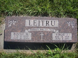
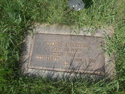
Bonnie Mae Savoie Leitru
| Birth | : | 11 Nov 1930 Vermillion, Clay County, South Dakota, USA |
| Death | : | 21 Sep 2002 Vermillion, Clay County, South Dakota, USA |
| Burial | : | Pleasant Valley Cemetery, Westerville, Clay County, USA |
| Coordinate | : | 42.9247017, -97.0124969 |
frequently asked questions (FAQ):
-
Where is Bonnie Mae Savoie Leitru's memorial?
Bonnie Mae Savoie Leitru's memorial is located at: Pleasant Valley Cemetery, Westerville, Clay County, USA.
-
When did Bonnie Mae Savoie Leitru death?
Bonnie Mae Savoie Leitru death on 21 Sep 2002 in Vermillion, Clay County, South Dakota, USA
-
Where are the coordinates of the Bonnie Mae Savoie Leitru's memorial?
Latitude: 42.9247017
Longitude: -97.0124969
Family Members:
Parent

Spouse
Siblings
Children
Flowers:


Nearby Cemetories:
1. Pleasant Valley Cemetery
Westerville, Clay County, USA
Coordinate: 42.9247017, -97.0124969
2. Mortvedt Cemetery
Clay County, USA
Coordinate: 42.9169006, -97.0028000
3. Bethel Baptist Cemetery
Wakonda, Clay County, USA
Coordinate: 42.9393570, -97.0433520
4. New Lodi Cemetery
Lodi, Clay County, USA
Coordinate: 42.9530983, -97.0417023
5. Saint Patricks Catholic Cemetery
Wakonda, Clay County, USA
Coordinate: 42.9672012, -97.0516968
6. Old Lodi Cemetery
Lodi, Clay County, USA
Coordinate: 42.9757996, -96.9907990
7. Spirit Mound Cemetery
Clay County, USA
Coordinate: 42.8885994, -96.9424973
8. Dalesburg Lutheran Cemetery
Vermillion, Clay County, USA
Coordinate: 42.9389424, -96.9242594
9. Clay Creek Cemetery
Clay County, USA
Coordinate: 42.8516998, -96.9788971
10. Clay Point Cemetery
Prairie Center Township, Clay County, USA
Coordinate: 42.8987700, -96.9065600
11. Union Cemetery
Wakonda, Clay County, USA
Coordinate: 42.9827995, -97.1222000
12. Taylor Cemetery
Clay County, USA
Coordinate: 42.8372002, -97.0785980
13. CJ Anderson Homestead
Riverside Township, Clay County, USA
Coordinate: 43.0214180, -96.9675540
14. Dalesburg Baptist Cemetery
Dalesburg, Clay County, USA
Coordinate: 42.9675102, -96.8850403
15. Meckling Cemetery
Meckling, Clay County, USA
Coordinate: 42.8252983, -97.0919037
16. Riverside-Barton Cemetery
Clay County, USA
Coordinate: 43.0402985, -96.9725037
17. Volin Cemetery
Volin, Yankton County, USA
Coordinate: 42.9672012, -97.1707993
18. Saint Peter Greenfield Cemetery
Vermillion, Clay County, USA
Coordinate: 42.8608017, -96.8644028
19. Gayville Community Cemetery
Gayville, Yankton County, USA
Coordinate: 42.8950005, -97.1800003
20. Rockfield Cemetery
Clay County, USA
Coordinate: 42.9397011, -96.8302994
21. Komstad Cemetery
Dalesburg, Clay County, USA
Coordinate: 43.0417938, -96.9058914
22. Evergreen Cemetery
Meckling, Clay County, USA
Coordinate: 42.7896996, -97.0903015
23. Saint Columbkill Cemetery
Wakonda, Clay County, USA
Coordinate: 43.0642014, -97.0828018
24. Trinity Danish Lutheran Church Cemetery
Gayville, Yankton County, USA
Coordinate: 42.8222008, -97.1605988