
| Birth | : | 11 May 1929 Wood River, Hall County, Nebraska, USA |
| Death | : | 10 May 2009 Elwood, Gosper County, Nebraska, USA |
| Burial | : | Saints Cornelius and Cyprian Parish Cemetery, Leslie, Ingham County, USA |
| Coordinate | : | 42.4901009, -84.3065033 |
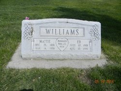
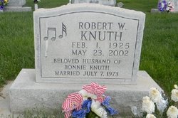
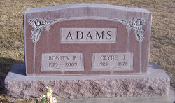
| Description | : | Daughter of Edward & Mattie (Likes) Williams. Married to: 1. Clyde Adams on 5-2-1948 at Lexington, NE. Deceaed 1971. 2. Robert "Bob" Knuth on 7-7-1973 at Lexington, NE. Deceased. |
frequently asked questions (FAQ):
-
Where is Bonnie Williams Knuth's memorial?
Bonnie Williams Knuth's memorial is located at: Saints Cornelius and Cyprian Parish Cemetery, Leslie, Ingham County, USA.
-
When did Bonnie Williams Knuth death?
Bonnie Williams Knuth death on 10 May 2009 in Elwood, Gosper County, Nebraska, USA
-
Where are the coordinates of the Bonnie Williams Knuth's memorial?
Latitude: 42.4901009
Longitude: -84.3065033
Family Members:
Parent

Spouse
Siblings
Flowers:


Nearby Cemetories:
1. Saints Cornelius and Cyprian Parish Cemetery
Leslie, Ingham County, USA
Coordinate: 42.4901009, -84.3065033
2. Bunker Hill Cemetery
Bunker Hill, Ingham County, USA
Coordinate: 42.4722870, -84.3172250
3. Holt Cemetery
Dansville, Ingham County, USA
Coordinate: 42.5111008, -84.2683029
4. Felt Plains Cemetery
Leslie, Ingham County, USA
Coordinate: 42.4874992, -84.3585968
5. Howard Cemetery
Dansville, Ingham County, USA
Coordinate: 42.5363998, -84.3031006
6. Fitchburg Cemetery
Stockbridge, Ingham County, USA
Coordinate: 42.4389000, -84.3007965
7. Mount Pleasant Cemetery
Dansville, Ingham County, USA
Coordinate: 42.5196991, -84.2399979
8. Fairview Cemetery
Dansville, Ingham County, USA
Coordinate: 42.5550003, -84.2956009
9. Nims Cemetery
Henrietta Township, Jackson County, USA
Coordinate: 42.4169006, -84.3343964
10. Derby Cemetery
Stockbridge, Ingham County, USA
Coordinate: 42.4464210, -84.2188330
11. Hawley Cemetery
Mason, Ingham County, USA
Coordinate: 42.5508003, -84.3792038
12. Eden Cemetery
Mason, Ingham County, USA
Coordinate: 42.5210991, -84.4191971
13. Old Belknap Farm Burial Ground
Munith, Jackson County, USA
Coordinate: 42.4073560, -84.2599580
14. Woodlawn Cemetery
Leslie, Ingham County, USA
Coordinate: 42.4570274, -84.4298935
15. Munith Cemetery
Munith, Jackson County, USA
Coordinate: 42.4014015, -84.2455978
16. North Stockbridge Cemetery
Stockbridge, Ingham County, USA
Coordinate: 42.5099983, -84.1703033
17. Oaklawn Cemetery
Stockbridge, Ingham County, USA
Coordinate: 42.4474983, -84.1742020
18. Pleasant Grove Cemetery
Henrietta Township, Jackson County, USA
Coordinate: 42.3782997, -84.2891998
19. Rolfe Cemetery
Mason, Ingham County, USA
Coordinate: 42.5243988, -84.4569016
20. Spaulding Cemetery
Williamston, Ingham County, USA
Coordinate: 42.6096992, -84.3086014
21. East Rives Cemetery
Rives Junction, Jackson County, USA
Coordinate: 42.3863700, -84.3935700
22. Kinch Cemetery
Henrietta Township, Jackson County, USA
Coordinate: 42.3657990, -84.3116989
23. Moss Cemetery
Waterloo, Jackson County, USA
Coordinate: 42.3722420, -84.2293015
24. Dubois Cemetery
Mason, Ingham County, USA
Coordinate: 42.6091995, -84.3861008